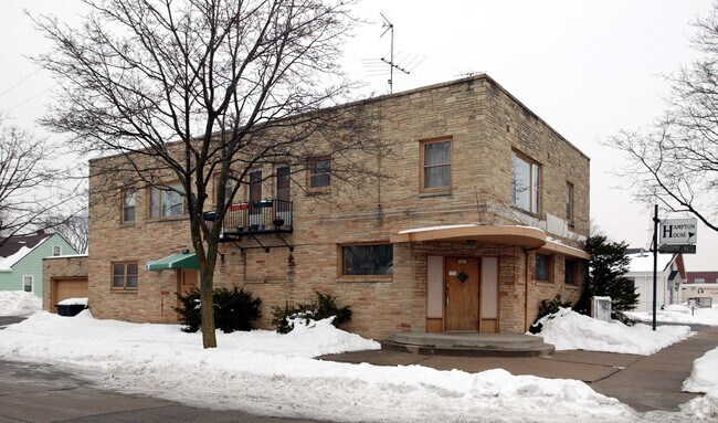
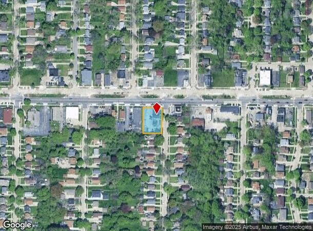
Property Record
5403 W Hampton Ave, Milwaukee, WI 53218
NEARBY LISTINGS FOR SALE OR LEASE
Property Detail
5403 W Hampton Ave
Milwaukee-Waukesha, WI
Assessment Subd No 68
227-0160-110-X
ASSESSMENT SUBD NO 68 IN NW 1/4 SEC 2-7-21 BLOCK 4 LOT 27 EXC N 55 & E 25 FOR ST
Bartavern
Milwaukee
X
Wisconsin
55079C0076E
27
2024
0.36 AC
2024
Milwaukee NW
003100
Milwaukee/Madison
4,200 SF
DEMOGRAPHICS near 5403 W Hampton Ave
1 mile
3 mile
5 mile
2024 Total Population
24,041
179,614
378,558
2029 Population
23,665
176,994
372,787
Pop Growth 2024-2029
(1.56%)
(1.46%)
(1.52%)
Average Age
35
36
37
2024 Total Households
8,845
70,051
154,178
HH Growth 2024-2029
(1.68%)
(1.57%)
(1.65%)
Median Household Inc
$36,801
$42,161
$48,369
Avg Household Size
2.60
2.50
2.40
2024 Avg HH Vehicles
1.00
1.00
1.00
Median Home Value
$93,136
$128,590
$177,764
Median Year Built
1953
1952
1952
Nearby Places
Map Layers
Map Styles
 Street
 Aerial
Transit
 Traffic
 Biking
Places
Listings with unknown addresses are not visible on the map
- Restaurants
- Banks
- Shops
- Fitness
- Groceries
PUBLIC TRANSPORTATION
COMMUTER RAIL
Drive
Walk
Distance
17 min
6.4 mi
AIRPORT
General Mitchell International
Drive
Walk
Distance
General Mitchell International
28 min
13.1 mi
Freight Ports
Port Milwaukee
Drive
Walk
Distance
Port Milwaukee
21 min
8.9 mi
SALE & LEASE HISTORY
LISTING DATE
SALE/LEASE

May 21, 2022
For Sale
Nearby Properties
Address
Land Use
TOTAL SIZE
Lot Size
Zoning
Address
Land Use
TOTAL SIZE
Lot Size
Zoning
527,776 SF
33.23 AC
Address
Land Use
TOTAL SIZE
Lot Size
Zoning
0.71 AC
RM2
Address
Land Use
TOTAL SIZE
Lot Size
Zoning
0.71 AC
RM2
Address
Land Use
TOTAL SIZE
Lot Size
Zoning
8.03 AC
RM1
Address
Land Use
TOTAL SIZE
Lot Size
Zoning
1.76 AC
LB2
Address
Land Use
TOTAL SIZE
Lot Size
Zoning
298,666 SF
5.09 AC
PD
Address
Land Use
TOTAL SIZE
Lot Size
Zoning
10,200 SF
0.25 AC
LB2
Address
Land Use
TOTAL SIZE
Lot Size
Zoning
12.49 AC
TL
Address
Land Use
TOTAL SIZE
Lot Size
Zoning
72,676 SF
6.22 AC
Address
Land Use
TOTAL SIZE
Lot Size
Zoning
66.42 AC
IL1
Address
Land Use
TOTAL SIZE
Lot Size
Zoning
17.84 AC
TL
Address
Land Use
TOTAL SIZE
Lot Size
Zoning
169,550 SF
12.04 AC
RB2
Address
Land Use
TOTAL SIZE
Lot Size
Zoning
48,540 SF
4.28 AC
Address
Land Use
TOTAL SIZE
Lot Size
Zoning
18.54 AC
RS6
Address
Land Use
TOTAL SIZE
Lot Size
Zoning
17.91 AC
RS5
Address
Land Use
TOTAL SIZE
Lot Size
Zoning
61,910 SF
7.84 AC
Address
Land Use
TOTAL SIZE
Lot Size
Zoning
36,755 SF
6.44 AC
Address
Land Use
TOTAL SIZE
Lot Size
Zoning
0.51 AC
RT2
Address
Land Use
TOTAL SIZE
Lot Size
Zoning
7.38 AC
TL
Address
Land Use
TOTAL SIZE
Lot Size
Zoning
333,971 SF
16.93 AC
IL1
Address
Land Use
TOTAL SIZE
Lot Size
Zoning
166,245 SF
55 AC
PD
Address
Land Use
TOTAL SIZE
Lot Size
Zoning
6.66 AC
RT3
Address
Land Use
TOTAL SIZE
Lot Size
Zoning
28.12 AC
RM1
Address
Land Use
TOTAL SIZE
Lot Size
Zoning
11.45 AC
RS6
Address
Land Use
TOTAL SIZE
Lot Size
Zoning
23.38 AC
RS6
Address
Land Use
TOTAL SIZE
Lot Size
Zoning
17,613 SF
1.44 AC
Address
Land Use
TOTAL SIZE
Lot Size
Zoning
163,539 SF
7.17 AC
PUD
Address
Land Use
TOTAL SIZE
Lot Size
Zoning
122,360 SF
PD
Address
Land Use
TOTAL SIZE
Lot Size
Zoning
9.94 AC
IL1
Address
Land Use
TOTAL SIZE
Lot Size
Zoning
1.40 AC
RM1
The World's #1 Commercial Real Estate Marketplace
Connect with us
© 2026 CoStar Group
The information above has been obtained from sources believed reliable. While we do not doubt its accuracy we have not verified it and make no guarantee, warranty or representation about it. It is your responsibility to independently confirm its accuracy and completeness. Any projections, opinions, assumptions, or estimates used are for example only and do not represent the current or future performance of the property. The value of this transaction to you depends on tax and other factors which should be evaluated by your tax, financial, and legal advisors. You and your advisors should conduct a careful, independent investigation of the property to determine to your satisfaction the suitability of the property for your needs.