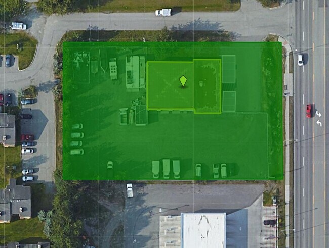
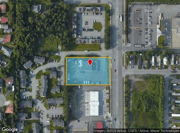
Property Record
5406 Lake Otis Pky, Anchorage, AK 99507
NEARBY LISTINGS FOR SALE OR LEASE
Property Detail
5406 Lake Otis Pky
00926193000
Mac Mc Coy Sudivision 02
Warehouse
MAC MC COY TR 1
X
Anchorage
0200050762D
Alaska
2024
1.12 AC
2025
E Tudor/Abbott-35
001801
Anchorage
5,550 SF
Anchorage, AK
DEMOGRAPHICS near 5406 Lake Otis Pky
1 Mile
3 Mile
5 Mile
2024 Total Population
14,399
94,030
223,450
2029 Population
14,247
92,968
220,500
Pop Growth 2024-2029
(1.06%)
(1.13%)
(1.32%)
Average Age
37
38
38
2024 Total Households
5,727
37,352
85,562
HH Growth 2024-2029
(0.87%)
(1.13%)
(1.37%)
Median Household Inc
$80,208
$77,441
$83,070
Avg Household Size
2.40
2.40
2.50
2024 Avg HH Vehicles
2.00
2.00
2.00
Median Home Value
$270,514
$291,929
$329,964
Median Year Built
1983
1980
1980
Nearby Places
Map Layers
Map Styles
 Street
 Aerial
- Restaurants
- Banks
- Shops
- Fitness
- Groceries
PUBLIC TRANSPORTATION
AIRPORT
Merrill Field
DRIVE
WALK
Distance
Merrill Field
8 min
3.5 mi
Ted Stevens Anchorage International
DRIVE
WALK
Distance
Ted Stevens Anchorage International
12 min
6.2 mi
Nearby Properties
Address
Land Use
TOTAL SIZE
Lot Size
Zoning
Address
Land Use
TOTAL SIZE
Lot Size
Zoning
658,690 SF
70.86 AC
PLI
Address
Land Use
TOTAL SIZE
Lot Size
Zoning
22,362 SF
71.05 AC
PLI
Address
Land Use
TOTAL SIZE
Lot Size
Zoning
380,635 SF
10.82 AC
B3
Address
Land Use
TOTAL SIZE
Lot Size
Zoning
14,009 SF
24.86 AC
PLI
Address
Land Use
TOTAL SIZE
Lot Size
Zoning
160,830 SF
41.64 AC
PLI
Address
Land Use
TOTAL SIZE
Lot Size
Zoning
171,692 SF
23.09 AC
I1
Address
Land Use
TOTAL SIZE
Lot Size
Zoning
33,906 SF
40 AC
PLI
Address
Land Use
TOTAL SIZE
Lot Size
Zoning
117,702 SF
9.85 AC
B3SL
Address
Land Use
TOTAL SIZE
Lot Size
Zoning
134,626 SF
16.91 AC
PLI
Address
Land Use
TOTAL SIZE
Lot Size
Zoning
381,477 SF
33.30 AC
B3
Address
Land Use
TOTAL SIZE
Lot Size
Zoning
61,127 SF
3.04 AC
B3
Address
Land Use
TOTAL SIZE
Lot Size
Zoning
41,034 SF
6.28 AC
B3
Address
Land Use
TOTAL SIZE
Lot Size
Zoning
121,359 SF
4.35 AC
B3SL
Address
Land Use
TOTAL SIZE
Lot Size
Zoning
120,000 SF
9.09 AC
PLI
Address
Land Use
TOTAL SIZE
Lot Size
Zoning
104,412 SF
2.79 AC
B3SL
Address
Land Use
TOTAL SIZE
Lot Size
Zoning
124,058 SF
18.15 AC
B3
Address
Land Use
TOTAL SIZE
Lot Size
Zoning
133,758 SF
2.36 AC
ROSL
Address
Land Use
TOTAL SIZE
Lot Size
Zoning
56,747 SF
6.89 AC
B3SL
Address
Land Use
TOTAL SIZE
Lot Size
Zoning
271,555 SF
55.40 AC
PLI
Address
Land Use
TOTAL SIZE
Lot Size
Zoning
64,695 SF
13.66 AC
PLI
Address
Land Use
TOTAL SIZE
Lot Size
Zoning
66,354 SF
44.23 AC
I2
Address
Land Use
TOTAL SIZE
Lot Size
Zoning
320,366 SF
36.42 AC
PLI
Address
Land Use
TOTAL SIZE
Lot Size
Zoning
242,189 SF
21.83 AC
I2
Address
Land Use
TOTAL SIZE
Lot Size
Zoning
168,640 SF
3.38 AC
I2
Address
Land Use
TOTAL SIZE
Lot Size
Zoning
24,120 SF
4.68 AC
B3
Address
Land Use
TOTAL SIZE
Lot Size
Zoning
84,157 SF
3.41 AC
B3
Address
Land Use
TOTAL SIZE
Lot Size
Zoning
112,874 SF
6.61 AC
ROSL
Address
Land Use
TOTAL SIZE
Lot Size
Zoning
217,754 SF
14.42 AC
I1
Address
Land Use
TOTAL SIZE
Lot Size
Zoning
49,217 SF
4.76 AC
B3
Address
Land Use
TOTAL SIZE
Lot Size
Zoning
171,800 SF
1.67 AC
B3
The World's #1 Commercial Real Estate Marketplace
Connect with us
© 2025 CoStar Group
The information above has been obtained from sources believed reliable. While we do not doubt its accuracy we have not verified it and make no guarantee, warranty or representation about it. It is your responsibility to independently confirm its accuracy and completeness. Any projections, opinions, assumptions, or estimates used are for example only and do not represent the current or future performance of the property. The value of this transaction to you depends on tax and other factors which should be evaluated by your tax, financial, and legal advisors. You and your advisors should conduct a careful, independent investigation of the property to determine to your satisfaction the suitability of the property for your needs.