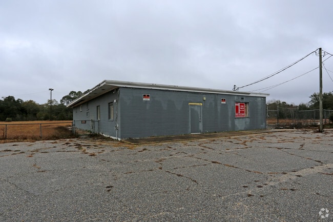
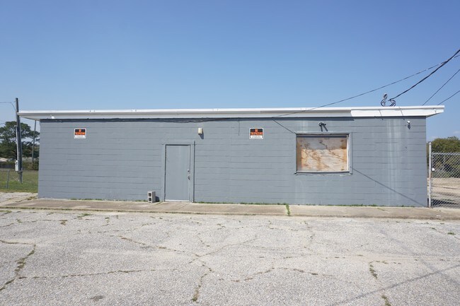
Property Record
1200 N Blk N 57Th Ave, Pensacola, FL 32506

Current Lease Availabilities
NEARBY LISTINGS FOR SALE OR LEASE
Property Detail
1200 N Blk N 57Th Ave
Pensacola-Ferry Pass-Brent, FL
Subdivision Number: 1900
35-2S-30-1900-000-001
BEG AT SE COR OF LT 1 N 16 DEG 30 MIN W WITH E LI OF LT 870 52/100 FT TO N R/W LI OF LILLIAN H/W S 78 DEG 53 MIN W ALG H/W 1097 66/100 FT FOR POB CONTINUE SAME COURSE 6 38/100 FT N 1 DEG 12 MIN E 250 FT S 79 DEG 1 MIN W 439 88/100 FT N 0 DEG 17 MIN W
Nightclub
Escambia
X
Florida
12033C0370G
1,870
2024
1 AC
2025
West Pensacola
002704
Pensacola
3,496 SF
DEMOGRAPHICS near 1200 N Blk N 57Th Ave
1 Mile
3 Mile
5 Mile
2024 Total Population
8,181
69,564
127,258
2029 Population
8,312
71,033
130,326
Pop Growth 2024-2029
+ 1.60%
+ 2.11%
+ 2.41%
Average Age
39
37
38
2024 Total Households
3,394
26,973
48,488
HH Growth 2024-2029
+ 1.59%
+ 2.05%
+ 2.47%
Median Household Inc
$36,466
$42,883
$42,680
Avg Household Size
2.30
2.40
2.30
2024 Avg HH Vehicles
2.00
2.00
2.00
Median Home Value
$119,123
$120,365
$146,611
Median Year Built
1964
1974
1975
Nearby Places
Map Layers
Map Styles
 Street
 Aerial
- Restaurants
- Banks
- Shops
- Fitness
- Groceries
PUBLIC TRANSPORTATION
AIRPORT
Pensacola International
DRIVE
WALK
Distance
Pensacola International
17 min
7.8 mi
Freight Ports
Port of Mobile
DRIVE
WALK
Distance
Port of Mobile
69 min
55.7 mi
Nearby Properties
Address
Land Use
TOTAL SIZE
Lot Size
Zoning
Address
Land Use
TOTAL SIZE
Lot Size
Zoning
6,950 SF
584.36 AC
PUB
Address
Land Use
TOTAL SIZE
Lot Size
Zoning
288,114 SF
17.89 AC
HC/LI
Address
Land Use
TOTAL SIZE
Lot Size
Zoning
250,232 SF
19.24 AC
HDR
Address
Land Use
TOTAL SIZE
Lot Size
Zoning
207,331 SF
24.09 AC
HDR
Address
Land Use
TOTAL SIZE
Lot Size
Zoning
219,481 SF
161.44 AC
NONE
Address
Land Use
TOTAL SIZE
Lot Size
Zoning
334,324 SF
55.06 AC
PUB
Address
Land Use
TOTAL SIZE
Lot Size
Zoning
188,512 SF
11.44 AC
COM
Address
Land Use
TOTAL SIZE
Lot Size
Zoning
127,684 SF
8.24 AC
HDR
Address
Land Use
TOTAL SIZE
Lot Size
Zoning
169,963 SF
15.43 AC
HC/LI
Address
Land Use
TOTAL SIZE
Lot Size
Zoning
169,346 SF
15.21 AC
HDR
Address
Land Use
TOTAL SIZE
Lot Size
Zoning
133,096 SF
10.32 AC
HDR
Address
Land Use
TOTAL SIZE
Lot Size
Zoning
151,996 SF
30.44 AC
HDR
Address
Land Use
TOTAL SIZE
Lot Size
Zoning
130,830 SF
26.30 AC
M-2
Address
Land Use
TOTAL SIZE
Lot Size
Zoning
158,233 SF
9.15 AC
HDMU
Address
Land Use
TOTAL SIZE
Lot Size
Zoning
99,147 SF
5.89 AC
HDMU
Address
Land Use
TOTAL SIZE
Lot Size
Zoning
116,020 SF
4.71 AC
MDR
Address
Land Use
TOTAL SIZE
Lot Size
Zoning
197,958 SF
26.08 AC
COM
Address
Land Use
TOTAL SIZE
Lot Size
Zoning
184,232 SF
11.32 AC
HC/LI
Address
Land Use
TOTAL SIZE
Lot Size
Zoning
129,532 SF
10.84 AC
COM
Address
Land Use
TOTAL SIZE
Lot Size
Zoning
103,671 SF
13.96 AC
HDMU
Address
Land Use
TOTAL SIZE
Lot Size
Zoning
137,411 SF
15.02 AC
COM
Address
Land Use
TOTAL SIZE
Lot Size
Zoning
146,790 SF
8.83 AC
C-1,C-3
Address
Land Use
TOTAL SIZE
Lot Size
Zoning
138,048 SF
22.64 AC
HC/LI
Address
Land Use
TOTAL SIZE
Lot Size
Zoning
124,146 SF
5.79 AC
HDMU
Address
Land Use
TOTAL SIZE
Lot Size
Zoning
371,425 SF
24.78 AC
HC/LI
Address
Land Use
TOTAL SIZE
Lot Size
Zoning
223,987 SF
36.60 AC
MDR
Address
Land Use
TOTAL SIZE
Lot Size
Zoning
557,783 SF
39.80 AC
M-2
Address
Land Use
TOTAL SIZE
Lot Size
Zoning
81,874 SF
7.09 AC
HDMU
Address
Land Use
TOTAL SIZE
Lot Size
Zoning
77,074 SF
5.79 AC
HC/LI
Address
Land Use
TOTAL SIZE
Lot Size
Zoning
61,788 SF
8.60 AC
HDR
The World's #1 Commercial Real Estate Marketplace
Connect with us
© 2026 CoStar Group
The information above has been obtained from sources believed reliable. While we do not doubt its accuracy we have not verified it and make no guarantee, warranty or representation about it. It is your responsibility to independently confirm its accuracy and completeness. Any projections, opinions, assumptions, or estimates used are for example only and do not represent the current or future performance of the property. The value of this transaction to you depends on tax and other factors which should be evaluated by your tax, financial, and legal advisors. You and your advisors should conduct a careful, independent investigation of the property to determine to your satisfaction the suitability of the property for your needs.