Property Record
5409 Crenshaw Rd, Pasadena, TX 77505
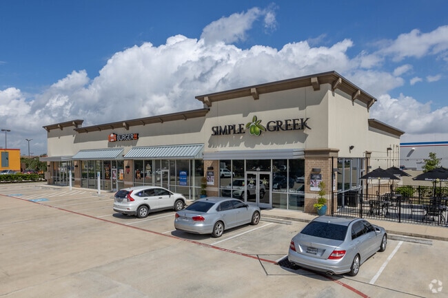

Property Detail
5409 Crenshaw Rd
1328440010005
RES A2 BLK 1 VALBOONE PLACE
Storebuilding
HARRIS
AE The base floodplain where base flood elevations are provided. AE Zones are now used on new format FIRMs instead of A1-A30 Zones.
Texas
2024
0.96 AC
2025
NASA/Clear Lake
342002
Houston
7,980 SF
Houston-Pasadena-The Woodlands, TX
NEARBY LISTINGS FOR SALE OR LEASE
DEMOGRAPHICS near 5409 Crenshaw Rd
1 mile
3 mile
5 mile
2025 Total Population
7,049
77,067
287,462
2030 Population
7,444
82,554
306,133
Pop Growth 2025-2030
+ 5.60%
+ 7.12%
+ 6.50%
Average Age
39
38
37
2025 Total Households
2,705
27,160
98,025
HH Growth 2025-2030
+ 5.77%
+ 7.19%
+ 6.68%
Median Household Inc
$96,383
$68,668
$72,318
Avg Household Size
2.60
2.80
2.90
2025 Avg HH Vehicles
2.00
2.00
2.00
Median Home Value
$297,625
$270,900
$251,099
Median Year Built
1995
1989
1980
Nearby Places
Map Layers
Map Styles
 Street
 Aerial
Layers
 Traffic
 Biking
Places
Listings with unknown addresses are not visible on the map
- Restaurants
- Banks
- Shops
- Fitness
- Groceries
PUBLIC TRANSPORTATION
AIRPORT
William P Hobby
Drive
Walk
Distance
William P Hobby
20 min
8.7 mi
George Bush Intcntl/Houston
Drive
Walk
Distance
George Bush Intcntl/Houston
41 min
32.3 mi
Freight Ports
Port of Houston
Drive
Walk
Distance
Port of Houston
25 min
13.9 mi
SALE & LEASE HISTORY
LISTING DATE
SALE/LEASE

May 17, 2023
For Sale
Jan 22, 2024
For Sale
Nearby Properties
Address
Land Use
TOTAL SIZE
Lot Size
Zoning
Address
Land Use
TOTAL SIZE
Lot Size
Zoning
6,478,017 SF
135.61 AC
Address
Land Use
TOTAL SIZE
Lot Size
Zoning
552,961 SF
25.01 AC
Address
Land Use
TOTAL SIZE
Lot Size
Zoning
345,420 SF
4.02 AC
Address
Land Use
TOTAL SIZE
Lot Size
Zoning
319,549 SF
20.70 AC
Address
Land Use
TOTAL SIZE
Lot Size
Zoning
236,508 SF
24.19 AC
Address
Land Use
TOTAL SIZE
Lot Size
Zoning
309,779 SF
19.57 AC
Address
Land Use
TOTAL SIZE
Lot Size
Zoning
135.61 AC
Address
Land Use
TOTAL SIZE
Lot Size
Zoning
414,017 SF
19.28 AC
Address
Land Use
TOTAL SIZE
Lot Size
Zoning
173,293 SF
19.70 AC
Address
Land Use
TOTAL SIZE
Lot Size
Zoning
226,250 SF
13.69 AC
Address
Land Use
TOTAL SIZE
Lot Size
Zoning
359,223 SF
17.24 AC
Address
Land Use
TOTAL SIZE
Lot Size
Zoning
283,010 SF
14.61 AC
Address
Land Use
TOTAL SIZE
Lot Size
Zoning
281,470 SF
11.24 AC
Address
Land Use
TOTAL SIZE
Lot Size
Zoning
112,782 SF
8.18 AC
Address
Land Use
TOTAL SIZE
Lot Size
Zoning
276,029 SF
14.44 AC
Address
Land Use
TOTAL SIZE
Lot Size
Zoning
260,915 SF
15.98 AC
Address
Land Use
TOTAL SIZE
Lot Size
Zoning
147,671 SF
17.84 AC
Address
Land Use
TOTAL SIZE
Lot Size
Zoning
460,310 SF
23.40 AC
Address
Land Use
TOTAL SIZE
Lot Size
Zoning
157,845 SF
12.52 AC
Address
Land Use
TOTAL SIZE
Lot Size
Zoning
800,000 SF
135.61 AC
Address
Land Use
TOTAL SIZE
Lot Size
Zoning
219,143 SF
10.84 AC
Address
Land Use
TOTAL SIZE
Lot Size
Zoning
120,304 SF
7.55 AC
Address
Land Use
TOTAL SIZE
Lot Size
Zoning
105,885 SF
10.19 AC
Address
Land Use
TOTAL SIZE
Lot Size
Zoning
203,931 SF
25.06 AC
Address
Land Use
TOTAL SIZE
Lot Size
Zoning
446,728 SF
16.69 AC
Address
Land Use
TOTAL SIZE
Lot Size
Zoning
102,274 SF
11.35 AC
Address
Land Use
TOTAL SIZE
Lot Size
Zoning
169,338 SF
10.19 AC
Address
Land Use
TOTAL SIZE
Lot Size
Zoning
172,093 SF
21.87 AC
Address
Land Use
TOTAL SIZE
Lot Size
Zoning
75,007 SF
4.26 AC
Address
Land Use
TOTAL SIZE
Lot Size
Zoning
52,091 SF
5.68 AC
The World's #1 Commercial Real Estate Marketplace
Connect with us
© 2026 CoStar Group
The information above has been obtained from sources believed reliable. While we do not doubt its accuracy we have not verified it and make no guarantee, warranty or representation about it. It is your responsibility to independently confirm its accuracy and completeness. Any projections, opinions, assumptions, or estimates used are for example only and do not represent the current or future performance of the property. The value of this transaction to you depends on tax and other factors which should be evaluated by your tax, financial, and legal advisors. You and your advisors should conduct a careful, independent investigation of the property to determine to your satisfaction the suitability of the property for your needs.