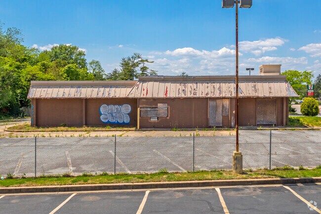
Property Record
5409 Silver Hill Rd, District Heights, MD 20747


Save to a Folder
{{folder.Name}}
{{folder.ListingIds.length}} Properties
{{folder.ListingIds.length}} Property
Create a New Folder
Property Detail
5409 Silver Hill Rd
06-0575621
PARCEL F
Restaurantdrivein
Prince Georges
CGO
Maryland
B and X Area of moderate flood hazard, usually the area between the limits of the 100-year and 500-year floods.
0.75 AC
2024
Pennsylvania Ave Corridor
2025
Washington, DC
802002
Washington-Arlington-Alexandria, DC-VA-MD-WV
2,615 SF
NEARBY LISTINGS FOR SALE OR LEASE
DEMOGRAPHICS near 5409 Silver Hill Rd
1 mile
3 mile
5 mile
2025 Total Population
21,439
150,109
400,960
2030 Population
21,633
153,725
415,953
Pop Growth 2025-2030
+ 0.90%
+ 2.41%
+ 3.74%
Average Age
40
40
39
2025 Total Households
9,106
61,588
161,054
HH Growth 2025-2030
+ 0.91%
+ 2.64%
+ 4.12%
Median Household Inc
$69,997
$73,672
$74,844
Avg Household Size
2.30
2.40
2.40
2025 Avg HH Vehicles
1.00
1.00
1.00
Median Home Value
$320,902
$338,577
$350,081
Median Year Built
1972
1966
1967
Nearby Places
Map Layers
Map Styles
 Street
 Aerial
Layers
 Traffic
 Biking
Places
Listings with unknown addresses are not visible on the map
- Restaurants
- Banks
- Shops
- Fitness
- Groceries
PUBLIC TRANSPORTATION
COMMUTER RAIL
Union Station (Red Line - Washington Metropolitan Area Transit Authority Metrorail (Metrorail))
Drive
Walk
Distance
Union Station (Red Line - Washington Metropolitan Area Transit Authority Metrorail (Metrorail))
16 min
7.1 mi
Drive
Walk
Distance
14 min
7.3 mi
AIRPORT
Ronald Reagan Washington Ntl
Drive
Walk
Distance
Ronald Reagan Washington Ntl
22 min
11.3 mi
Baltimore/Washington International Thurgood Marshall
Drive
Walk
Distance
Baltimore/Washington International Thurgood Marshall
50 min
32.3 mi
Washington Dulles International
Drive
Walk
Distance
Washington Dulles International
59 min
35.7 mi
Freight Ports
Port of Baltimore
Drive
Walk
Distance
Port of Baltimore
58 min
38.6 mi
SALE & LEASE HISTORY
LISTING DATE
SALE/LEASE

Oct 09, 2019
For Lease
May 18, 2017
For Lease
May 18, 2017
For Sale
Dec 14, 2020
For Sale
Aug 06, 2019
For Lease
Nearby Properties
Address
Land Use
TOTAL SIZE
Lot Size
Zoning
Address
Land Use
TOTAL SIZE
Lot Size
Zoning
2,131,229 SF
144.34 AC
AG
Address
Land Use
TOTAL SIZE
Lot Size
Zoning
963,250 SF
10.71 AC
RTOLE
Address
Land Use
TOTAL SIZE
Lot Size
Zoning
417 SF
7.66 AC
RTOLE
Address
Land Use
TOTAL SIZE
Lot Size
Zoning
26.64 AC
RMF20
Address
Land Use
TOTAL SIZE
Lot Size
Zoning
262,236 SF
15.26 AC
MU-8B
Address
Land Use
TOTAL SIZE
Lot Size
Zoning
6 AC
RTOLE
Address
Land Use
TOTAL SIZE
Lot Size
Zoning
62,797 SF
0.55 AC
R2
Address
Land Use
TOTAL SIZE
Lot Size
Zoning
111.87 AC
IE
Address
Land Use
TOTAL SIZE
Lot Size
Zoning
262 SF
24.86 AC
RMF20
Address
Land Use
TOTAL SIZE
Lot Size
Zoning
99,269 SF
4.73 AC
RA-1
Address
Land Use
TOTAL SIZE
Lot Size
Zoning
142,636 SF
3.69 AC
RA-1
Address
Land Use
TOTAL SIZE
Lot Size
Zoning
13.21 AC
RMF48
Address
Land Use
TOTAL SIZE
Lot Size
Zoning
115,788 SF
1.77 AC
MU-4;RA-1
Address
Land Use
TOTAL SIZE
Lot Size
Zoning
29.49 AC
RSFA
Address
Land Use
TOTAL SIZE
Lot Size
Zoning
17.90 AC
RMF20
Address
Land Use
TOTAL SIZE
Lot Size
Zoning
21.48 AC
RMF20
Address
Land Use
TOTAL SIZE
Lot Size
Zoning
22.67 AC
RMF20
Address
Land Use
TOTAL SIZE
Lot Size
Zoning
383,961 SF
2.90 AC
MU-7B
Address
Land Use
TOTAL SIZE
Lot Size
Zoning
17.08 AC
RMF20
Address
Land Use
TOTAL SIZE
Lot Size
Zoning
245,767 SF
13.88 AC
CGO
Address
Land Use
TOTAL SIZE
Lot Size
Zoning
11.82 AC
RMF20
Address
Land Use
TOTAL SIZE
Lot Size
Zoning
340 SF
22.69 AC
R-2;RA-1
Address
Land Use
TOTAL SIZE
Lot Size
Zoning
15.65 AC
RMF20
Address
Land Use
TOTAL SIZE
Lot Size
Zoning
238,785 SF
12.79 AC
CGO
Address
Land Use
TOTAL SIZE
Lot Size
Zoning
26.64 AC
RA-1
Address
Land Use
TOTAL SIZE
Lot Size
Zoning
5.87 AC
RMF48
Address
Land Use
TOTAL SIZE
Lot Size
Zoning
11.20 AC
RMF20
Address
Land Use
TOTAL SIZE
Lot Size
Zoning
13.74 AC
RMF20
Address
Land Use
TOTAL SIZE
Lot Size
Zoning
4,059 SF
16.82 AC
IE
Address
Land Use
TOTAL SIZE
Lot Size
Zoning
133,840 SF
33.35 AC
IE
The World's #1 Commercial Real Estate Marketplace
Connect with us
© 2026 CoStar Group
The information above has been obtained from sources believed reliable. While we do not doubt its accuracy we have not verified it and make no guarantee, warranty or representation about it. It is your responsibility to independently confirm its accuracy and completeness. Any projections, opinions, assumptions, or estimates used are for example only and do not represent the current or future performance of the property. The value of this transaction to you depends on tax and other factors which should be evaluated by your tax, financial, and legal advisors. You and your advisors should conduct a careful, independent investigation of the property to determine to your satisfaction the suitability of the property for your needs.