Property Record
5409 Sw Scholls Ferry Rd, Portland, OR 97225
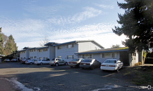

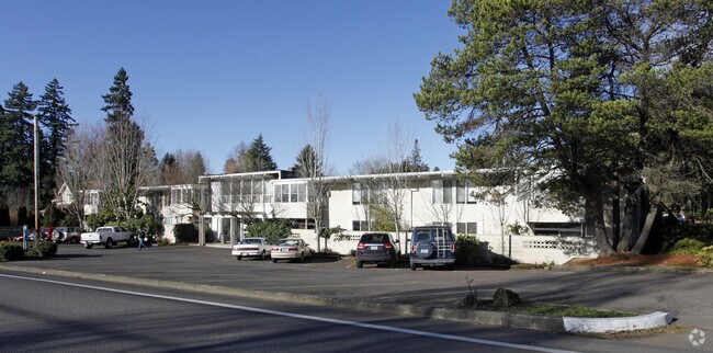
Property Detail
5409 Sw Scholls Ferry Rd
R0097996
ACRES 1.00
Apartment
WASHINGTON
R-24
Oregon
B and X Area of moderate flood hazard, usually the area between the limits of the 100-year and 500-year floods.
1 AC
2024
Raleigh Hills
2026
Portland
030401
Portland-Vancouver-Hillsboro, OR-WA
NEARBY LISTINGS FOR SALE OR LEASE
DEMOGRAPHICS near 5409 Sw Scholls Ferry Rd
1 mile
3 mile
5 mile
2025 Total Population
12,375
121,933
367,280
2030 Population
12,465
122,268
369,304
Pop Growth 2025-2030
+ 0.73%
+ 0.27%
+ 0.55%
Average Age
44
42
41
2025 Total Households
5,607
51,324
161,327
HH Growth 2025-2030
+ 0.75%
+ 0.30%
+ 0.58%
Median Household Inc
$96,673
$101,267
$100,076
Avg Household Size
2.20
2.30
2.20
2025 Avg HH Vehicles
2.00
2.00
2.00
Median Home Value
$798,132
$700,951
$700,324
Median Year Built
1970
1974
1981
Nearby Places
Map Layers
Map Styles
 Street
 Aerial
Layers
 Traffic
 Biking
Places
Listings with unknown addresses are not visible on the map
- Restaurants
- Banks
- Shops
- Fitness
- Groceries
PUBLIC TRANSPORTATION
COMMUTER RAIL
Hall/Nimbus (Westside Express Service - Tri-County Metropolitan Transportation District of Oregon Rail (TriMet Rail))
Drive
Walk
Distance
Hall/Nimbus (Westside Express Service - Tri-County Metropolitan Transportation District of Oregon Rail (TriMet Rail))
6 min
2.5 mi
Beaverton Transit Center (West Side Express) (Westside Express Service - Tri-County Metropolitan Transportation District of Oregon Rail (TriMet Rail))
Drive
Walk
Distance
Beaverton Transit Center (West Side Express) (Westside Express Service - Tri-County Metropolitan Transportation District of Oregon Rail (TriMet Rail))
8 min
2.7 mi
AIRPORT
Portland International
Drive
Walk
Distance
Portland International
32 min
19.0 mi
Freight Ports
Port of Portland
Drive
Walk
Distance
Port of Portland
16 min
8.0 mi
Nearby Properties
Address
Land Use
TOTAL SIZE
Lot Size
Zoning
Address
Land Use
TOTAL SIZE
Lot Size
Zoning
0.08 AC
IND
Address
Land Use
TOTAL SIZE
Lot Size
Zoning
57,314 SF
60.69 AC
OS
Address
Land Use
TOTAL SIZE
Lot Size
Zoning
303,158 SF
18.18 AC
R10
Address
Land Use
TOTAL SIZE
Lot Size
Zoning
97,465 SF
107.18 AC
OS
Address
Land Use
TOTAL SIZE
Lot Size
Zoning
461,858 SF
36.37 AC
CS
Address
Land Use
TOTAL SIZE
Lot Size
Zoning
1,380,937 SF
36.42 AC
INST
Address
Land Use
TOTAL SIZE
Lot Size
Zoning
359,574 SF
6.75 AC
R-9
Address
Land Use
TOTAL SIZE
Lot Size
Zoning
79,646 SF
9.23 AC
R2R7
Address
Land Use
TOTAL SIZE
Lot Size
Zoning
179,180 SF
36.77 AC
INST
Address
Land Use
TOTAL SIZE
Lot Size
Zoning
155,201 SF
4.04 AC
R7
Address
Land Use
TOTAL SIZE
Lot Size
Zoning
43,537 SF
3.59 AC
MUC
Address
Land Use
TOTAL SIZE
Lot Size
Zoning
234,391 SF
0.13 AC
CS
Address
Land Use
TOTAL SIZE
Lot Size
Zoning
37.55 AC
IND
Address
Land Use
TOTAL SIZE
Lot Size
Zoning
62,647 SF
9.65 AC
R7
Address
Land Use
TOTAL SIZE
Lot Size
Zoning
372,200 SF
34.75 AC
CS
Address
Land Use
TOTAL SIZE
Lot Size
Zoning
11,736 SF
2.85 AC
MUE-1
Address
Land Use
TOTAL SIZE
Lot Size
Zoning
285,650 SF
26.94 AC
INST
Address
Land Use
TOTAL SIZE
Lot Size
Zoning
423,095 SF
21.51 AC
R1
Address
Land Use
TOTAL SIZE
Lot Size
Zoning
270,237 SF
22.44 AC
R-15
Address
Land Use
TOTAL SIZE
Lot Size
Zoning
62,693 SF
16.43 AC
CC
Address
Land Use
TOTAL SIZE
Lot Size
Zoning
431,653 SF
10.76 AC
R1
Address
Land Use
TOTAL SIZE
Lot Size
Zoning
159,473 SF
12.58 AC
RC-BC
Address
Land Use
TOTAL SIZE
Lot Size
Zoning
8.05 AC
Address
Land Use
TOTAL SIZE
Lot Size
Zoning
4,046 SF
4.08 AC
MUE-1
Address
Land Use
TOTAL SIZE
Lot Size
Zoning
87,200 SF
8.81 AC
R7
Address
Land Use
TOTAL SIZE
Lot Size
Zoning
517,403 SF
3.21 AC
MUE-1
Address
Land Use
TOTAL SIZE
Lot Size
Zoning
18.78 AC
R-15
Address
Land Use
TOTAL SIZE
Lot Size
Zoning
140,938 SF
7.02 AC
C-WS
Address
Land Use
TOTAL SIZE
Lot Size
Zoning
262,880 SF
0.95 AC
CX
Address
Land Use
TOTAL SIZE
Lot Size
Zoning
3.88 AC
CS
The World's #1 Commercial Real Estate Marketplace
Connect with us
© 2026 CoStar Group
The information above has been obtained from sources believed reliable. While we do not doubt its accuracy we have not verified it and make no guarantee, warranty or representation about it. It is your responsibility to independently confirm its accuracy and completeness. Any projections, opinions, assumptions, or estimates used are for example only and do not represent the current or future performance of the property. The value of this transaction to you depends on tax and other factors which should be evaluated by your tax, financial, and legal advisors. You and your advisors should conduct a careful, independent investigation of the property to determine to your satisfaction the suitability of the property for your needs.