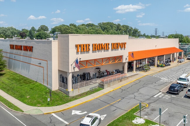
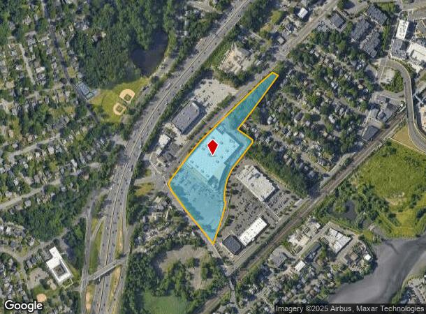
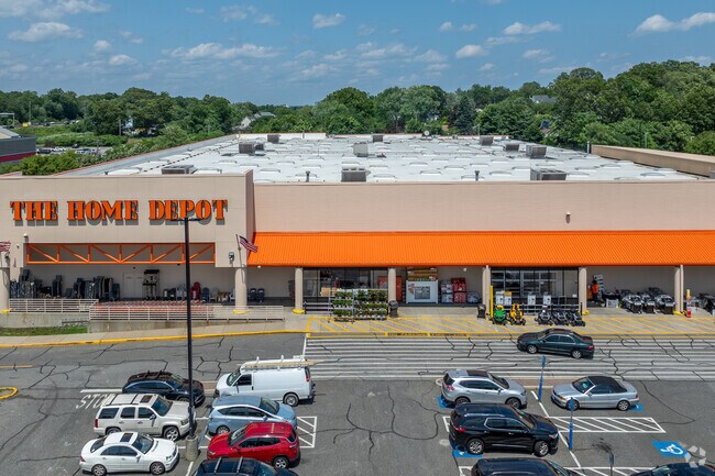
Property Record
541 Kings Highway Cutoff, Fairfield, CT 06824
NEARBY LISTINGS FOR SALE OR LEASE
Property Detail
541 Kings Highway Cutoff
Commercialbuilding
Fairfield
AE
Connecticut
09001C0436G
9.19 AC
2025
Fairfield
2025
Westchester/So Connecticut
061400
Bridgeport-Stamford-Norwalk, CT
98,056 SF
FAIR-000128-000000-000124
DEMOGRAPHICS near 541 Kings Highway Cutoff
1 Mile
3 Mile
5 Mile
2024 Total Population
18,294
102,960
209,765
2029 Population
18,346
103,205
210,053
Pop Growth 2024-2029
+ 0.28%
+ 0.24%
+ 0.14%
Average Age
36
38
38
2024 Total Households
6,386
37,189
74,214
HH Growth 2024-2029
+ 0.53%
+ 0.20%
+ 0.08%
Median Household Inc
$101,997
$73,350
$66,732
Avg Household Size
2.30
2.60
2.60
2024 Avg HH Vehicles
2.00
2.00
2.00
Median Home Value
$455,877
$509,619
$388,700
Median Year Built
1959
1954
1955
Nearby Places
Map Layers
Map Styles
 Street
 Aerial
- Restaurants
- Banks
- Shops
- Fitness
- Groceries
PUBLIC TRANSPORTATION
COMMUTER RAIL
DRIVE
WALK
Distance
3 min
11 min
0.6 mi
Fairfield Station (New Haven Line - Metro-North Commuter Railroad Company (Metro-North))
DRIVE
WALK
Distance
Fairfield Station (New Haven Line - Metro-North Commuter Railroad Company (Metro-North))
5 min
1.7 mi
AIRPORT
Tweed/New Haven
DRIVE
WALK
Distance
Tweed/New Haven
42 min
25.3 mi
Westchester County
DRIVE
WALK
Distance
Westchester County
49 min
31.0 mi
Long Island MacArthur
DRIVE
WALK
Distance
Long Island MacArthur
112 min
37.1 mi
Freight Ports
Port of New Haven
DRIVE
WALK
Distance
Port of New Haven
36 min
23.1 mi
Nearby Properties
Address
Land Use
TOTAL SIZE
Lot Size
Zoning
Address
Land Use
TOTAL SIZE
Lot Size
Zoning
Address
Land Use
TOTAL SIZE
Lot Size
Zoning
124 AC
FPD
Address
Land Use
TOTAL SIZE
Lot Size
Zoning
23.95 AC
RB
Address
Land Use
TOTAL SIZE
Lot Size
Zoning
111 AC
RA
Address
Land Use
TOTAL SIZE
Lot Size
Zoning
335,633 SF
39.70 AC
R3
Address
Land Use
TOTAL SIZE
Lot Size
Zoning
19.43 AC
A
Address
Land Use
TOTAL SIZE
Lot Size
Zoning
1,183 SF
2.33 AC
DID
Address
Land Use
TOTAL SIZE
Lot Size
Zoning
288,875 SF
1.57 AC
MUEM
Address
Land Use
TOTAL SIZE
Lot Size
Zoning
213,826 SF
18.30 AC
A
Address
Land Use
TOTAL SIZE
Lot Size
Zoning
146,351 SF
8.86 AC
Address
Land Use
TOTAL SIZE
Lot Size
Zoning
162,376 SF
7.82 AC
Address
Land Use
TOTAL SIZE
Lot Size
Zoning
10.28 AC
DID
Address
Land Use
TOTAL SIZE
Lot Size
Zoning
260,992 SF
4.19 AC
ILI
Address
Land Use
TOTAL SIZE
Lot Size
Zoning
493,114 SF
2.20 AC
DCB
Address
Land Use
TOTAL SIZE
Lot Size
Zoning
144,086 SF
3.12 AC
DRD
Address
Land Use
TOTAL SIZE
Lot Size
Zoning
22.43 AC
R3
Address
Land Use
TOTAL SIZE
Lot Size
Zoning
115,006 SF
2.51 AC
DCD
Address
Land Use
TOTAL SIZE
Lot Size
Zoning
12.47 AC
AA
Address
Land Use
TOTAL SIZE
Lot Size
Zoning
216,972 SF
2.53 AC
DCB
Address
Land Use
TOTAL SIZE
Lot Size
Zoning
14.90 AC
RC
Address
Land Use
TOTAL SIZE
Lot Size
Zoning
5.31 AC
RC
Address
Land Use
TOTAL SIZE
Lot Size
Zoning
16.73 AC
DCD
Address
Land Use
TOTAL SIZE
Lot Size
Zoning
79,739 SF
1.53 AC
PDD
Address
Land Use
TOTAL SIZE
Lot Size
Zoning
204,000 SF
1.84 AC
MUEM
Address
Land Use
TOTAL SIZE
Lot Size
Zoning
7.52 AC
RC
Address
Land Use
TOTAL SIZE
Lot Size
Zoning
2 AC
DCB
Address
Land Use
TOTAL SIZE
Lot Size
Zoning
101,558 SF
7.74 AC
ORN
Address
Land Use
TOTAL SIZE
Lot Size
Zoning
6.43 AC
DCD
Address
Land Use
TOTAL SIZE
Lot Size
Zoning
116,202 SF
2.39 AC
MUEM
Address
Land Use
TOTAL SIZE
Lot Size
Zoning
92,057 SF
10.20 AC
B
The World's #1 Commercial Real Estate Marketplace
Connect with us
© 2026 CoStar Group
The information above has been obtained from sources believed reliable. While we do not doubt its accuracy we have not verified it and make no guarantee, warranty or representation about it. It is your responsibility to independently confirm its accuracy and completeness. Any projections, opinions, assumptions, or estimates used are for example only and do not represent the current or future performance of the property. The value of this transaction to you depends on tax and other factors which should be evaluated by your tax, financial, and legal advisors. You and your advisors should conduct a careful, independent investigation of the property to determine to your satisfaction the suitability of the property for your needs.