Property Record
541 Thayer Ave, Silver Spring, MD 20910
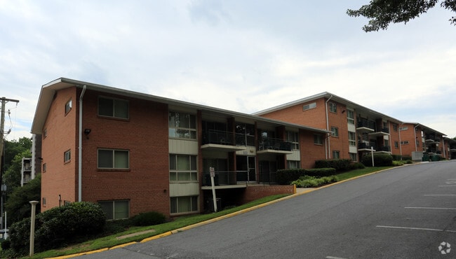


Property Detail
541 Thayer Ave
13-01043766
PAR W SILVER SPRING PARK
Apartment
MONTGOMERY
R10
Maryland
B and X Area of moderate flood hazard, usually the area between the limits of the 100-year and 500-year floods.
w
2024
2.08 AC
2025
Silver Spring Park
702402
Washington, DC
86,328 SF
Washington-Arlington-Alexandria, DC-VA-MD-WV
NEARBY LISTINGS FOR SALE OR LEASE
DEMOGRAPHICS near 541 Thayer Ave
1 mile
3 mile
5 mile
2025 Total Population
46,326
250,212
620,771
2030 Population
48,023
257,899
641,177
Pop Growth 2025-2030
+ 3.66%
+ 3.07%
+ 3.29%
Average Age
39
39
39
2025 Total Households
22,382
92,246
239,107
HH Growth 2025-2030
+ 3.86%
+ 3.53%
+ 3.79%
Median Household Inc
$92,687
$104,061
$110,148
Avg Household Size
2.00
2.60
2.50
2025 Avg HH Vehicles
1.00
1.00
1.00
Median Home Value
$682,873
$541,536
$520,665
Median Year Built
1966
1958
1958
Nearby Places
Map Layers
Map Styles
 Street
 Aerial
Transit
 Traffic
 Biking
Places
Listings with unknown addresses are not visible on the map
- Restaurants
- Banks
- Shops
- Fitness
- Groceries
PUBLIC TRANSPORTATION
TRANSIT/SUBWAY
Silver Spring (Red Line - Washington Metropolitan Area Transit Authority Metrorail (Metrorail))
Drive
Walk
Distance
Silver Spring (Red Line - Washington Metropolitan Area Transit Authority Metrorail (Metrorail))
4 min
18 min
0.9 mi
COMMUTER RAIL
Silver Spring Marc Eb (BRUNSWICK - WASHINGTON - Maryland Transit Administration)
Drive
Walk
Distance
Silver Spring Marc Eb (BRUNSWICK - WASHINGTON - Maryland Transit Administration)
5 min
17 min
0.9 mi
Kensington Marc Eb (BRUNSWICK - WASHINGTON - Maryland Transit Administration)
Drive
Walk
Distance
Kensington Marc Eb (BRUNSWICK - WASHINGTON - Maryland Transit Administration)
12 min
4.4 mi
AIRPORT
Ronald Reagan Washington Ntl
Drive
Walk
Distance
Ronald Reagan Washington Ntl
24 min
12.2 mi
Washington Dulles International
Drive
Walk
Distance
Washington Dulles International
49 min
30.4 mi
Baltimore/Washington International Thurgood Marshall
Drive
Walk
Distance
Baltimore/Washington International Thurgood Marshall
42 min
30.7 mi
Freight Ports
Port of Baltimore
Drive
Walk
Distance
Port of Baltimore
46 min
33.5 mi
SALE & LEASE HISTORY
LISTING DATE
SALE/LEASE

Apr 27, 2022
For Sale
Nearby Properties
Address
Land Use
TOTAL SIZE
Lot Size
Zoning
Address
Land Use
TOTAL SIZE
Lot Size
Zoning
70,860 SF
1,616.16 AC
R-1A;UNZON
Address
Land Use
TOTAL SIZE
Lot Size
Zoning
775,490 SF
14.21 AC
R60
Address
Land Use
TOTAL SIZE
Lot Size
Zoning
1,144,541 SF
30.46 AC
CR2.5
Address
Land Use
TOTAL SIZE
Lot Size
Zoning
919,016 SF
3.25 AC
CR5.0
Address
Land Use
TOTAL SIZE
Lot Size
Zoning
505,000 SF
1.97 AC
CR8.0
Address
Land Use
TOTAL SIZE
Lot Size
Zoning
487,112 SF
3.19 AC
CR3.0
Address
Land Use
TOTAL SIZE
Lot Size
Zoning
869,190 SF
4.97 AC
RA-1
Address
Land Use
TOTAL SIZE
Lot Size
Zoning
302,861 SF
16.30 AC
R-1A
Address
Land Use
TOTAL SIZE
Lot Size
Zoning
400,000 SF
0.93 AC
CR5.0
Address
Land Use
TOTAL SIZE
Lot Size
Zoning
383,000 SF
2.29 AC
WR-3;WR-4
Address
Land Use
TOTAL SIZE
Lot Size
Zoning
305,000 SF
1.62 AC
CR5.0
Address
Land Use
TOTAL SIZE
Lot Size
Zoning
247,494 SF
WR-3;WR-5;
Address
Land Use
TOTAL SIZE
Lot Size
Zoning
134,394 SF
6.05 AC
WR-7;WR-8
Address
Land Use
TOTAL SIZE
Lot Size
Zoning
756,363 SF
2.66 AC
CR8.0
Address
Land Use
TOTAL SIZE
Lot Size
Zoning
403,200 SF
1.41 AC
CR5.0
Address
Land Use
TOTAL SIZE
Lot Size
Zoning
406,784 SF
1.75 AC
CR3.0
Address
Land Use
TOTAL SIZE
Lot Size
Zoning
590 SF
20.11 AC
LTOE
Address
Land Use
TOTAL SIZE
Lot Size
Zoning
386,567 SF
29.70 AC
R60
Address
Land Use
TOTAL SIZE
Lot Size
Zoning
301,045 SF
13.51 AC
R-1B
Address
Land Use
TOTAL SIZE
Lot Size
Zoning
304,888 SF
1.72 AC
CR5.0
Address
Land Use
TOTAL SIZE
Lot Size
Zoning
310,000 SF
1.01 AC
CR8.0
Address
Land Use
TOTAL SIZE
Lot Size
Zoning
269,319 SF
2.26 AC
MU-4;RA-1
Address
Land Use
TOTAL SIZE
Lot Size
Zoning
347,098 SF
7.27 AC
R60
Address
Land Use
TOTAL SIZE
Lot Size
Zoning
480,733 SF
2.10 AC
CR8.0
Address
Land Use
TOTAL SIZE
Lot Size
Zoning
111,525 SF
5.29 AC
R-1B
Address
Land Use
TOTAL SIZE
Lot Size
Zoning
468 SF
9.75 AC
RMF48
Address
Land Use
TOTAL SIZE
Lot Size
Zoning
5.03 AC
WR-4
Address
Land Use
TOTAL SIZE
Lot Size
Zoning
664,858 SF
106.79 AC
R90
Address
Land Use
TOTAL SIZE
Lot Size
Zoning
335,922 SF
1.22 AC
CR8.0
Address
Land Use
TOTAL SIZE
Lot Size
Zoning
142,318 SF
2.58 AC
WR-14
The World's #1 Commercial Real Estate Marketplace
Connect with us
© 2026 CoStar Group
The information above has been obtained from sources believed reliable. While we do not doubt its accuracy we have not verified it and make no guarantee, warranty or representation about it. It is your responsibility to independently confirm its accuracy and completeness. Any projections, opinions, assumptions, or estimates used are for example only and do not represent the current or future performance of the property. The value of this transaction to you depends on tax and other factors which should be evaluated by your tax, financial, and legal advisors. You and your advisors should conduct a careful, independent investigation of the property to determine to your satisfaction the suitability of the property for your needs.