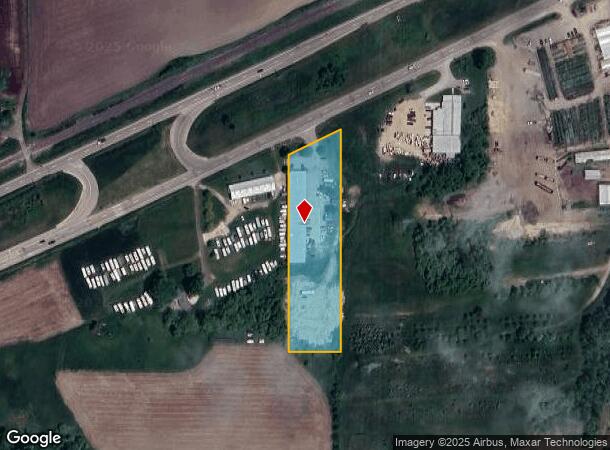
Property Record
5410 Chicago Dr, Hudsonville, MI 49426

Current Lease Availabilities
NEARBY LISTINGS FOR SALE OR LEASE
Property Detail
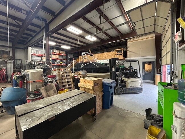
5410 Chicago Dr
70-17-01-300-038
PART OF SW 1/4 COM W 1/4 COR, TH S 89D 43M 27S E 132312 FT & S 0D 09M 36S E 35443 FT ALG E LI OF NW 1/4 OF SW 1/4 TO PT OF
Storebuilding
Ottawa
X
Michigan
26005C0075G
2.07 AC
2025
E Ottawa Cnty/Hudsonville
2025
West Michigan
021904
Grand Rapids-Wyoming-Kentwood, MI
12,480 SF
DEMOGRAPHICS near 5410 Chicago Dr
1 Mile
3 Mile
5 Mile
2024 Total Population
276
10,512
45,035
2029 Population
306
11,132
47,360
Pop Growth 2024-2029
+ 10.87%
+ 5.90%
+ 5.16%
Average Age
37
38
36
2024 Total Households
86
3,534
14,871
HH Growth 2024-2029
+ 10.47%
+ 5.91%
+ 5.25%
Median Household Inc
$109,375
$97,281
$98,095
Avg Household Size
3.20
2.90
3.00
2024 Avg HH Vehicles
3.00
2.00
2.00
Median Home Value
$332,758
$297,224
$290,512
Median Year Built
2006
1993
1995
Nearby Places
Map Layers
Map Styles
 Street
 Aerial
- Restaurants
- Banks
- Shops
- Fitness
- Groceries
PUBLIC TRANSPORTATION
AIRPORT
Gerald R Ford International
DRIVE
WALK
Distance
Gerald R Ford International
35 min
23.8 mi
Nearby Properties
Address
Land Use
TOTAL SIZE
Lot Size
Zoning
Address
Land Use
TOTAL SIZE
Lot Size
Zoning
273,515 SF
Address
Land Use
TOTAL SIZE
Lot Size
Zoning
392,381 SF
21.73 AC
SEE MAP
Address
Land Use
TOTAL SIZE
Lot Size
Zoning
85,799 SF
12.89 AC
SEE MAP
Address
Land Use
TOTAL SIZE
Lot Size
Zoning
116,088 SF
29.18 AC
N/A
Address
Land Use
TOTAL SIZE
Lot Size
Zoning
138,648 SF
Address
Land Use
TOTAL SIZE
Lot Size
Zoning
60,000 SF
18.36 AC
I-1
Address
Land Use
TOTAL SIZE
Lot Size
Zoning
103,308 SF
18.76 AC
N/A
Address
Land Use
TOTAL SIZE
Lot Size
Zoning
162,719 SF
19.77 AC
SEE MAP
Address
Land Use
TOTAL SIZE
Lot Size
Zoning
47,386 SF
6.93 AC
LDR
Address
Land Use
TOTAL SIZE
Lot Size
Zoning
6.29 AC
SEE MAP
Address
Land Use
TOTAL SIZE
Lot Size
Zoning
78,846 SF
8.73 AC
I
Address
Land Use
TOTAL SIZE
Lot Size
Zoning
142.51 AC
N/A
Address
Land Use
TOTAL SIZE
Lot Size
Zoning
91,450 SF
10.45 AC
SEE MAP
Address
Land Use
TOTAL SIZE
Lot Size
Zoning
0.50 AC
Address
Land Use
TOTAL SIZE
Lot Size
Zoning
38,017 SF
5.46 AC
HC
Address
Land Use
TOTAL SIZE
Lot Size
Zoning
103,976 SF
8.68 AC
IND-G
Address
Land Use
TOTAL SIZE
Lot Size
Zoning
50,578 SF
31.51 AC
SEE MAP
Address
Land Use
TOTAL SIZE
Lot Size
Zoning
28,526 SF
3.39 AC
HC
Address
Land Use
TOTAL SIZE
Lot Size
Zoning
42,914 SF
4.04 AC
SEE MAP
Address
Land Use
TOTAL SIZE
Lot Size
Zoning
28,912 SF
5.31 AC
I-2
Address
Land Use
TOTAL SIZE
Lot Size
Zoning
51,000 SF
4.25 AC
I-1
Address
Land Use
TOTAL SIZE
Lot Size
Zoning
83,310 SF
5.84 AC
SEE MAP
Address
Land Use
TOTAL SIZE
Lot Size
Zoning
162,816 SF
18.93 AC
SEE MAP
Address
Land Use
TOTAL SIZE
Lot Size
Zoning
32,576 SF
2.23 AC
PF
Address
Land Use
TOTAL SIZE
Lot Size
Zoning
62,589 SF
16.47 AC
SEE MAP
Address
Land Use
TOTAL SIZE
Lot Size
Zoning
84,528 SF
6.13 AC
I-1
Address
Land Use
TOTAL SIZE
Lot Size
Zoning
41,221 SF
8.22 AC
HC
Address
Land Use
TOTAL SIZE
Lot Size
Zoning
28,550 SF
8.52 AC
I-1
Address
Land Use
TOTAL SIZE
Lot Size
Zoning
24,678 SF
0.65 AC
CBD
Address
Land Use
TOTAL SIZE
Lot Size
Zoning
81,320 SF
4.97 AC
IND-G
The World's #1 Commercial Real Estate Marketplace
Connect with us
© 2026 CoStar Group
The information above has been obtained from sources believed reliable. While we do not doubt its accuracy we have not verified it and make no guarantee, warranty or representation about it. It is your responsibility to independently confirm its accuracy and completeness. Any projections, opinions, assumptions, or estimates used are for example only and do not represent the current or future performance of the property. The value of this transaction to you depends on tax and other factors which should be evaluated by your tax, financial, and legal advisors. You and your advisors should conduct a careful, independent investigation of the property to determine to your satisfaction the suitability of the property for your needs.