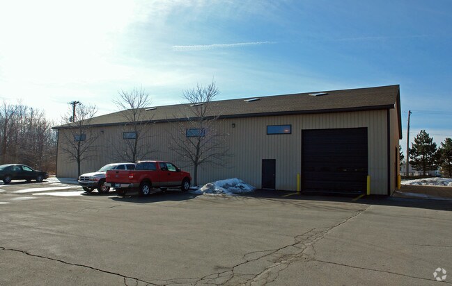
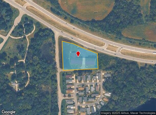
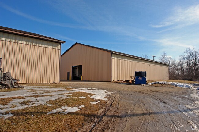
Property Record
5410 Highland Rd, White Lake, MI 48383
NEARBY LISTINGS FOR SALE OR LEASE
Property Detail
5410 Highland Rd
12-20-151-007
T3N, R8E, SEC 20 THAT PART OF SW 1/4 OF NW 1/4 LYING S OF M-59 HWY EXC W 60 FT, ALSO EXC THAT PART IN PARCEL BEG AT SE COR OF SW 1/4 OF NW 1/4, TH S 89-18-00 W 870 FT, TH N 226.20 FT, TH SELY 890 FT ALG CEN LINE OF M-59 HWY TO W 1/8 LINE, TH S 13.74
Warehouse
Oakland
X
Michigan
26125C0318F
2.31 AC
2024
Central I-96 Corridor
2024
Detroit
130300
Detroit-Warren-Dearborn, MI
20,636 SF
DEMOGRAPHICS near 5410 Highland Rd
1 Mile
3 Mile
5 Mile
2024 Total Population
2,305
18,452
63,147
2029 Population
2,306
18,302
62,751
Pop Growth 2024-2029
+ 0.04%
(0.81%)
(0.63%)
Average Age
38
42
43
2024 Total Households
932
7,066
24,234
HH Growth 2024-2029
0.00%
(0.81%)
(0.63%)
Median Household Inc
$68,796
$95,370
$97,922
Avg Household Size
2.50
2.60
2.60
2024 Avg HH Vehicles
2.00
2.00
2.00
Median Home Value
$75,925
$316,982
$327,136
Median Year Built
1983
1982
1982
Nearby Places
Map Layers
Map Styles
 Street
 Aerial
- Restaurants
- Banks
- Shops
- Fitness
- Groceries
PUBLIC TRANSPORTATION
AIRPORT
Bishop International
DRIVE
WALK
Distance
Bishop International
53 min
36.9 mi
Detroit Metro Wayne County
DRIVE
WALK
Distance
Detroit Metro Wayne County
60 min
42.2 mi
Nearby Properties
Address
Land Use
TOTAL SIZE
Lot Size
Zoning
Address
Land Use
TOTAL SIZE
Lot Size
Zoning
4,260 SF
101.34 AC
MM
Address
Land Use
TOTAL SIZE
Lot Size
Zoning
207,282 SF
55.01 AC
BI
Address
Land Use
TOTAL SIZE
Lot Size
Zoning
71,627 SF
13 AC
BV
Address
Land Use
TOTAL SIZE
Lot Size
Zoning
42,467 SF
13.70 AC
Address
Land Use
TOTAL SIZE
Lot Size
Zoning
46,500 SF
5.86 AC
BI
Address
Land Use
TOTAL SIZE
Lot Size
Zoning
65,345 SF
5.69 AC
GB
Address
Land Use
TOTAL SIZE
Lot Size
Zoning
88,540 SF
9.07 AC
PB
Address
Land Use
TOTAL SIZE
Lot Size
Zoning
34,854 SF
5.28 AC
AI
Address
Land Use
TOTAL SIZE
Lot Size
Zoning
103,525 SF
8.33 AC
PB
Address
Land Use
TOTAL SIZE
Lot Size
Zoning
45,644 SF
7.74 AC
BI
Address
Land Use
TOTAL SIZE
Lot Size
Zoning
38,846 SF
6.78 AC
BI
Address
Land Use
TOTAL SIZE
Lot Size
Zoning
24,370 SF
4.86 AC
BI
Address
Land Use
TOTAL SIZE
Lot Size
Zoning
23,300 SF
3.99 AC
BI
Address
Land Use
TOTAL SIZE
Lot Size
Zoning
58,677 SF
16.70 AC
II
Address
Land Use
TOTAL SIZE
Lot Size
Zoning
29,295 SF
15.15 AC
AI
Address
Land Use
TOTAL SIZE
Lot Size
Zoning
25,432 SF
4.53 AC
AI
Address
Land Use
TOTAL SIZE
Lot Size
Zoning
15.74 AC
MM
Address
Land Use
TOTAL SIZE
Lot Size
Zoning
12,463 SF
4.73 AC
Address
Land Use
TOTAL SIZE
Lot Size
Zoning
19,097 SF
6.04 AC
GB
Address
Land Use
TOTAL SIZE
Lot Size
Zoning
12,000 SF
1.43 AC
BI
Address
Land Use
TOTAL SIZE
Lot Size
Zoning
11,400 SF
1.44 AC
Address
Land Use
TOTAL SIZE
Lot Size
Zoning
24,027 SF
2.10 AC
BV
Address
Land Use
TOTAL SIZE
Lot Size
Zoning
13,000 SF
19.01 AC
II
Address
Land Use
TOTAL SIZE
Lot Size
Zoning
12,601 SF
2.54 AC
BI
Address
Land Use
TOTAL SIZE
Lot Size
Zoning
29,143 SF
9.62 AC
BI
Address
Land Use
TOTAL SIZE
Lot Size
Zoning
10,859 SF
2.70 AC
GB
Address
Land Use
TOTAL SIZE
Lot Size
Zoning
14,640 SF
1.65 AC
Address
Land Use
TOTAL SIZE
Lot Size
Zoning
14,350 SF
2.87 AC
LM
Address
Land Use
TOTAL SIZE
Lot Size
Zoning
18,769 SF
2.29 AC
BI
Address
Land Use
TOTAL SIZE
Lot Size
Zoning
4.25 AC
LB
The World's #1 Commercial Real Estate Marketplace
Connect with us
© 2025 CoStar Group
The information above has been obtained from sources believed reliable. While we do not doubt its accuracy we have not verified it and make no guarantee, warranty or representation about it. It is your responsibility to independently confirm its accuracy and completeness. Any projections, opinions, assumptions, or estimates used are for example only and do not represent the current or future performance of the property. The value of this transaction to you depends on tax and other factors which should be evaluated by your tax, financial, and legal advisors. You and your advisors should conduct a careful, independent investigation of the property to determine to your satisfaction the suitability of the property for your needs.