Property Record
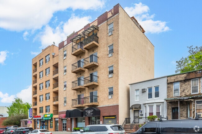
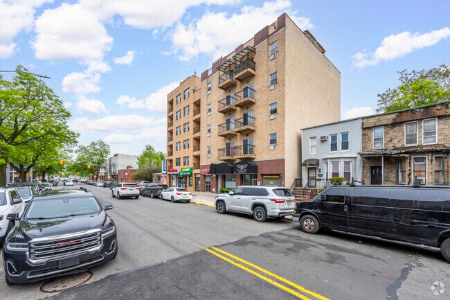
5411 2Nd Ave, Brooklyn, NY 11220

Property Detail
5411 2Nd Ave
00821-0005
Kings
Apartment
New York
R6A
5
B and X Area of moderate flood hazard, usually the area between the limits of the 100-year and 500-year floods.
0.12 AC
2025
Sunset Park
2026
Long Island (New York)
002200
New York-Jersey City-White Plains, NY-NJ
15,100 SF
NEARBY LISTINGS FOR SALE OR LEASE
DEMOGRAPHICS near 5411 2Nd Ave
1 mile
3 mile
5 mile
2025 Total Population
94,702
602,629
1,865,798
2030 Population
89,669
585,995
1,858,342
Pop Growth 2025-2030
(5.31%)
(2.76%)
(0.40%)
Average Age
39
39
39
2025 Total Households
28,866
204,840
688,474
HH Growth 2025-2030
(5.42%)
(2.89%)
(0.34%)
Median Household Inc
$65,408
$85,734
$88,075
Avg Household Size
3.10
2.80
2.60
2025 Avg HH Vehicles
.00
1.00
1.00
Median Home Value
$935,830
$1,044,523
$950,313
Median Year Built
1947
1947
1948
Nearby Places
Map Layers
Map Styles
 Street
 Aerial
Layers
 Traffic
 Biking
Places
Listings with unknown addresses are not visible on the map
- Restaurants
- Banks
- Shops
- Fitness
- Groceries
PUBLIC TRANSPORTATION
TRANSIT/SUBWAY
53 Street (N - New York MTA Subway (The Subway), R - New York MTA Subway (The Subway))
Drive
Walk
Distance
53 Street (N - New York MTA Subway (The Subway), R - New York MTA Subway (The Subway))
2 min
6 min
0.3 mi
59 Street (N,R Line) (N - New York MTA Subway (The Subway), R - New York MTA Subway (The Subway))
Drive
Walk
Distance
59 Street (N,R Line) (N - New York MTA Subway (The Subway), R - New York MTA Subway (The Subway))
3 min
10 min
0.5 mi
45 Street (N - New York MTA Subway (The Subway), R - New York MTA Subway (The Subway))
Drive
Walk
Distance
45 Street (N - New York MTA Subway (The Subway), R - New York MTA Subway (The Subway))
3 min
14 min
0.7 mi
Bay Ridge Avenue (R - New York MTA Subway (The Subway))
Drive
Walk
Distance
Bay Ridge Avenue (R - New York MTA Subway (The Subway))
3 min
20 min
1.0 mi
COMMUTER RAIL
Drive
Walk
Distance
12 min
4.2 mi
Clifton (Staten Island Railway - New York MTA Subway (The Subway))
Drive
Walk
Distance
Clifton (Staten Island Railway - New York MTA Subway (The Subway))
13 min
6.8 mi
AIRPORT
LaGuardia
Drive
Walk
Distance
LaGuardia
28 min
14.8 mi
John F Kennedy International
Drive
Walk
Distance
John F Kennedy International
30 min
15.7 mi
Newark Liberty International
Drive
Walk
Distance
Newark Liberty International
33 min
18.3 mi
Freight Ports
NY - Red Hook Container Terminal
Drive
Walk
Distance
NY - Red Hook Container Terminal
9 min
3.7 mi
SALE & LEASE HISTORY
LISTING DATE
SALE/LEASE

Sep 19, 2020
For Lease
Mar 04, 2019
For Lease
Jan 22, 2019
For Lease
Nearby Properties
Address
Land Use
TOTAL SIZE
Lot Size
Zoning
Address
Land Use
TOTAL SIZE
Lot Size
Zoning
92,440 SF
466.23 AC
R5
Address
Land Use
TOTAL SIZE
Lot Size
Zoning
393.54 AC
PARK
Address
Land Use
TOTAL SIZE
Lot Size
Zoning
1,524,659 SF
170.96 AC
R4
Address
Land Use
TOTAL SIZE
Lot Size
Zoning
577,381 SF
3.19 AC
R6
Address
Land Use
TOTAL SIZE
Lot Size
Zoning
902,000 SF
3.21 AC
M3-1
Address
Land Use
TOTAL SIZE
Lot Size
Zoning
965,600 SF
6.65 AC
R5
Address
Land Use
TOTAL SIZE
Lot Size
Zoning
460,000 SF
3.21 AC
R6
Address
Land Use
TOTAL SIZE
Lot Size
Zoning
1,186,339 SF
0.99 AC
M14R72
Address
Land Use
TOTAL SIZE
Lot Size
Zoning
335,800 SF
1.51 AC
R6
Address
Land Use
TOTAL SIZE
Lot Size
Zoning
1,324,592 SF
5.13 AC
M3-1
Address
Land Use
TOTAL SIZE
Lot Size
Zoning
397,354 SF
0.61 AC
C5-2
Address
Land Use
TOTAL SIZE
Lot Size
Zoning
427,208 SF
1.30 AC
R6
Address
Land Use
TOTAL SIZE
Lot Size
Zoning
393,092 SF
1.07 AC
R8A
Address
Land Use
TOTAL SIZE
Lot Size
Zoning
371,139 SF
3.22 AC
R5
Address
Land Use
TOTAL SIZE
Lot Size
Zoning
5,359,400 SF
59.07 AC
M2-1
Address
Land Use
TOTAL SIZE
Lot Size
Zoning
323,193 SF
2.05 AC
M14R72
Address
Land Use
TOTAL SIZE
Lot Size
Zoning
286,000 SF
12.63 AC
PARK
Address
Land Use
TOTAL SIZE
Lot Size
Zoning
25.67 AC
Address
Land Use
TOTAL SIZE
Lot Size
Zoning
1,785,288 SF
22.38 AC
M2-1
Address
Land Use
TOTAL SIZE
Lot Size
Zoning
689,850 SF
3.08 AC
M3-1
Address
Land Use
TOTAL SIZE
Lot Size
Zoning
346,260 SF
1.38 AC
M14R72
Address
Land Use
TOTAL SIZE
Lot Size
Zoning
1,466,751 SF
24.79 AC
R5
Address
Land Use
TOTAL SIZE
Lot Size
Zoning
558,525 SF
0.72 AC
M14R72
Address
Land Use
TOTAL SIZE
Lot Size
Zoning
336,534 SF
47.78 AC
M1-1
Address
Land Use
TOTAL SIZE
Lot Size
Zoning
673,895 SF
3.22 AC
M3-1
Address
Land Use
TOTAL SIZE
Lot Size
Zoning
317,742 SF
1.17 AC
M14R6A
Address
Land Use
TOTAL SIZE
Lot Size
Zoning
1,112,855 SF
3.52 AC
M3-1
Address
Land Use
TOTAL SIZE
Lot Size
Zoning
492,962 SF
8.12 AC
M1-1
Address
Land Use
TOTAL SIZE
Lot Size
Zoning
478,268 SF
4.04 AC
M3-1
Address
Land Use
TOTAL SIZE
Lot Size
Zoning
369,413 SF
1.50 AC
M14R72
The World's #1 Commercial Real Estate Marketplace
Connect with us
© 2026 CoStar Group
The information above has been obtained from sources believed reliable. While we do not doubt its accuracy we have not verified it and make no guarantee, warranty or representation about it. It is your responsibility to independently confirm its accuracy and completeness. Any projections, opinions, assumptions, or estimates used are for example only and do not represent the current or future performance of the property. The value of this transaction to you depends on tax and other factors which should be evaluated by your tax, financial, and legal advisors. You and your advisors should conduct a careful, independent investigation of the property to determine to your satisfaction the suitability of the property for your needs.