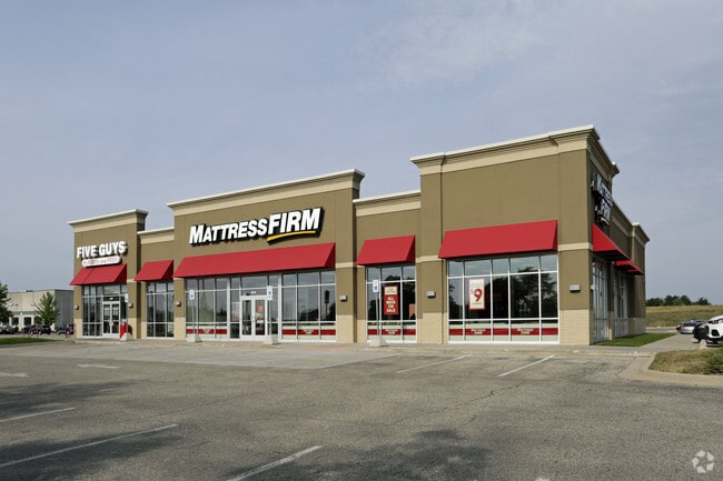
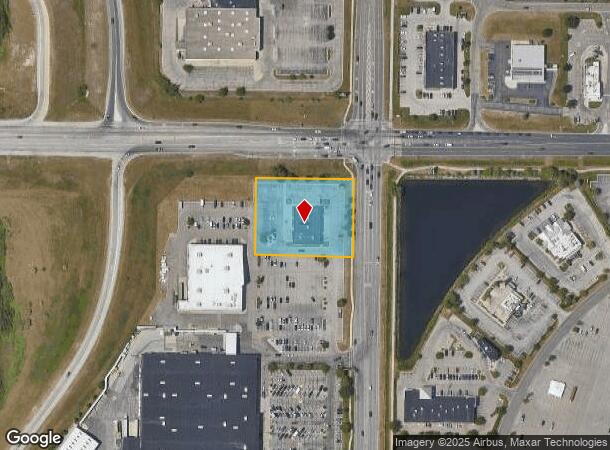
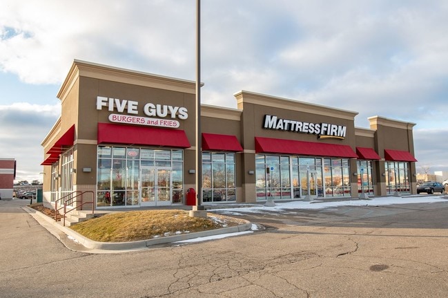
Property Record
5411 Harvey St, Norton Shores, MI 49444
NEARBY LISTINGS FOR SALE OR LEASE
Property Detail
5411 Harvey St
27-121-400-0005-20
CITY OF NORTON SHORES PART OF NE 1/4 SE 1/4 SEC 21 T9N R16W COM AT E 1/4 COR SD SEC 21 TH S 01D 36M 54S W ALG E LN SD SEC A D
Commercialnec
Muskegon
X
Michigan
26121C0289E
1.42 AC
2024
Norton Shores
2025
West Michigan
002602
Muskegon, MI
7,793 SF
DEMOGRAPHICS near 5411 Harvey St
1 Mile
3 Mile
5 Mile
2024 Total Population
1,752
19,761
73,124
2029 Population
1,790
19,894
74,335
Pop Growth 2024-2029
+ 2.17%
+ 0.67%
+ 1.66%
Average Age
43
42
41
2024 Total Households
773
8,000
27,905
HH Growth 2024-2029
+ 2.20%
+ 0.69%
+ 1.75%
Median Household Inc
$54,270
$66,524
$58,076
Avg Household Size
2.20
2.40
2.40
2024 Avg HH Vehicles
2.00
2.00
2.00
Median Home Value
$219,372
$194,655
$176,508
Median Year Built
2001
1984
1970
Nearby Places
Map Layers
Map Styles
 Street
 Aerial
- Restaurants
- Banks
- Shops
- Fitness
- Groceries
SALE & LEASE HISTORY
LISTING DATE
SALE/LEASE

Mar 19, 2019
For Sale
Nearby Properties
Address
Land Use
TOTAL SIZE
Lot Size
Zoning
Address
Land Use
TOTAL SIZE
Lot Size
Zoning
350,077 SF
41.42 AC
PUD
Address
Land Use
TOTAL SIZE
Lot Size
Zoning
273,059 SF
30.59 AC
PUD
Address
Land Use
TOTAL SIZE
Lot Size
Zoning
65,152 SF
9.77 AC
PUD
Address
Land Use
TOTAL SIZE
Lot Size
Zoning
147,000 SF
GI
Address
Land Use
TOTAL SIZE
Lot Size
Zoning
237,612 SF
13.40 AC
PUD
Address
Land Use
TOTAL SIZE
Lot Size
Zoning
250,000 SF
19.08 AC
GI
Address
Land Use
TOTAL SIZE
Lot Size
Zoning
275,714 SF
17.26 AC
PUD
Address
Land Use
TOTAL SIZE
Lot Size
Zoning
250,000 SF
15.60 AC
GI
Address
Land Use
TOTAL SIZE
Lot Size
Zoning
169,420 SF
15.20 AC
PUD
Address
Land Use
TOTAL SIZE
Lot Size
Zoning
149,707 SF
35.72 AC
GI
Address
Land Use
TOTAL SIZE
Lot Size
Zoning
91,682 SF
21.93 AC
PUD
Address
Land Use
TOTAL SIZE
Lot Size
Zoning
184,786 SF
24.10 AC
SUD
Address
Land Use
TOTAL SIZE
Lot Size
Zoning
125,059 SF
10.47 AC
PUD
Address
Land Use
TOTAL SIZE
Lot Size
Zoning
117,950 SF
10 AC
GI
Address
Land Use
TOTAL SIZE
Lot Size
Zoning
106,000 SF
GI
Address
Land Use
TOTAL SIZE
Lot Size
Zoning
141,007 SF
12.86 AC
GI
Address
Land Use
TOTAL SIZE
Lot Size
Zoning
118,532 SF
8.16 AC
REC
Address
Land Use
TOTAL SIZE
Lot Size
Zoning
63,512 SF
6.22 AC
PUD
Address
Land Use
TOTAL SIZE
Lot Size
Zoning
215,706 SF
23.21 AC
PUD
Address
Land Use
TOTAL SIZE
Lot Size
Zoning
50,252 SF
6.94 AC
C-2
Address
Land Use
TOTAL SIZE
Lot Size
Zoning
356,647 SF
53.83 AC
PUD
Address
Land Use
TOTAL SIZE
Lot Size
Zoning
65,204 SF
2.43 AC
PUD
Address
Land Use
TOTAL SIZE
Lot Size
Zoning
80,000 SF
GI
Address
Land Use
TOTAL SIZE
Lot Size
Zoning
68,782 SF
10.52 AC
C-2
Address
Land Use
TOTAL SIZE
Lot Size
Zoning
81,600 SF
10.30 AC
GI
Address
Land Use
TOTAL SIZE
Lot Size
Zoning
122.75 AC
R-2
Address
Land Use
TOTAL SIZE
Lot Size
Zoning
250,000 SF
17.53 AC
GI
Address
Land Use
TOTAL SIZE
Lot Size
Zoning
250,000 SF
18.72 AC
GI
Address
Land Use
TOTAL SIZE
Lot Size
Zoning
378,727 SF
44.76 AC
B-2
Address
Land Use
TOTAL SIZE
Lot Size
Zoning
158,430 SF
9.23 AC
GI
The World's #1 Commercial Real Estate Marketplace
Connect with us
© 2025 CoStar Group
The information above has been obtained from sources believed reliable. While we do not doubt its accuracy we have not verified it and make no guarantee, warranty or representation about it. It is your responsibility to independently confirm its accuracy and completeness. Any projections, opinions, assumptions, or estimates used are for example only and do not represent the current or future performance of the property. The value of this transaction to you depends on tax and other factors which should be evaluated by your tax, financial, and legal advisors. You and your advisors should conduct a careful, independent investigation of the property to determine to your satisfaction the suitability of the property for your needs.