Property Record
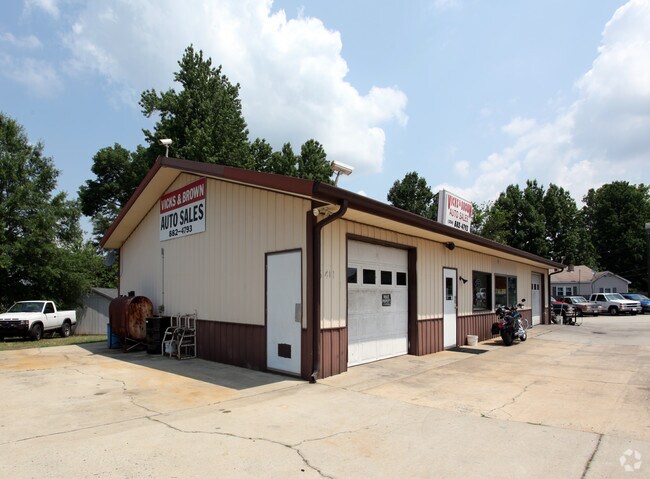
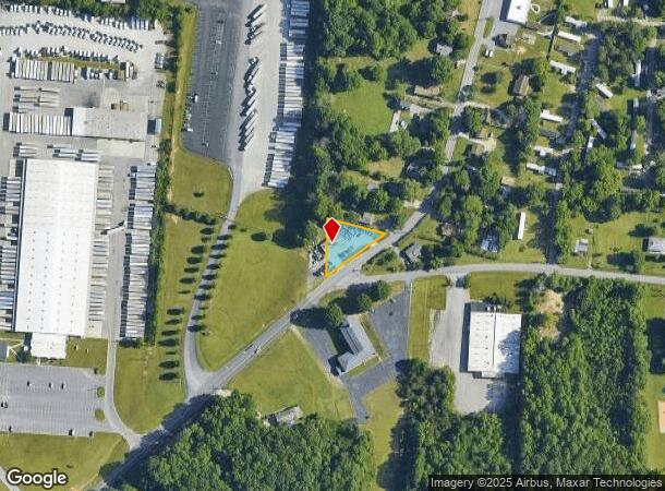
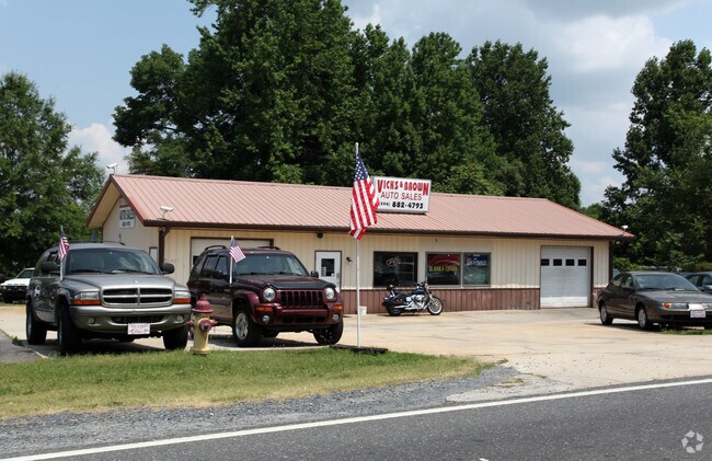
5411 Old Thomasville Rd, High Point, NC 27263
NEARBY LISTINGS FOR SALE OR LEASE
Property Detail
5411 Old Thomasville Rd
Greensboro-High Point, NC
W W Church Prop
6788-95-7217
W W CHURCH PROP LO:54 PL:2-31
Storesoffices
Randolph
X
North Carolina
3710678800J
54
2025
0.45 AC
2025
NW Randolph Cnty/Archdale
031601
Greensboro/Winston-Salem
2,184 SF
DEMOGRAPHICS near 5411 Old Thomasville Rd
1 Mile
3 Mile
5 Mile
2024 Total Population
3,461
30,346
77,968
2029 Population
3,667
31,814
80,839
Pop Growth 2024-2029
+ 5.95%
+ 4.84%
+ 3.68%
Average Age
39
39
40
2024 Total Households
1,376
11,974
31,201
HH Growth 2024-2029
+ 5.81%
+ 4.78%
+ 3.64%
Median Household Inc
$60,656
$49,803
$49,049
Avg Household Size
2.50
2.50
2.40
2024 Avg HH Vehicles
2.00
2.00
2.00
Median Home Value
$148,263
$152,134
$158,030
Median Year Built
1988
1977
1974
Nearby Places
Map Layers
Map Styles
 Street
 Aerial
- Restaurants
- Banks
- Shops
- Fitness
- Groceries
PUBLIC TRANSPORTATION
COMMUTER RAIL
High Point Station (Piedmont - North Carolina by Train (NC Train))
DRIVE
WALK
Distance
High Point Station (Piedmont - North Carolina by Train (NC Train))
10 min
6.0 mi
AIRPORT
Piedmont Triad International
DRIVE
WALK
Distance
Piedmont Triad International
33 min
21.7 mi
Nearby Properties
Address
Land Use
TOTAL SIZE
Lot Size
Zoning
Address
Land Use
TOTAL SIZE
Lot Size
Zoning
154,870 SF
62.93 AC
M1
Address
Land Use
TOTAL SIZE
Lot Size
Zoning
104,686 SF
12.97 AC
GB
Address
Land Use
TOTAL SIZE
Lot Size
Zoning
194,644 SF
20 AC
R10
Address
Land Use
TOTAL SIZE
Lot Size
Zoning
351,736 SF
34.77 AC
HI
Address
Land Use
TOTAL SIZE
Lot Size
Zoning
13,770 SF
34.64 AC
R10
Address
Land Use
TOTAL SIZE
Lot Size
Zoning
69,113 SF
7.87 AC
CU-PDM
Address
Land Use
TOTAL SIZE
Lot Size
Zoning
111,312 SF
7.98 AC
RM-26
Address
Land Use
TOTAL SIZE
Lot Size
Zoning
63,936 SF
19.05 AC
R10
Address
Land Use
TOTAL SIZE
Lot Size
Zoning
426,585 SF
27.46 AC
HI
Address
Land Use
TOTAL SIZE
Lot Size
Zoning
51,230 SF
7.52 AC
C2
Address
Land Use
TOTAL SIZE
Lot Size
Zoning
56,305 SF
5.39 AC
OI
Address
Land Use
TOTAL SIZE
Lot Size
Zoning
223,806 SF
12.60 AC
HI
Address
Land Use
TOTAL SIZE
Lot Size
Zoning
82,160 SF
23.62 AC
C2
Address
Land Use
TOTAL SIZE
Lot Size
Zoning
27,310 SF
20.06 AC
HI
Address
Land Use
TOTAL SIZE
Lot Size
Zoning
121,473 SF
32.77 AC
RM-16
Address
Land Use
TOTAL SIZE
Lot Size
Zoning
108,429 SF
14.43 AC
RC
Address
Land Use
TOTAL SIZE
Lot Size
Zoning
57,885 SF
24.14 AC
RA3
Address
Land Use
TOTAL SIZE
Lot Size
Zoning
72,642 SF
10.53 AC
R10
Address
Land Use
TOTAL SIZE
Lot Size
Zoning
124,326 SF
13.45 AC
C3
Address
Land Use
TOTAL SIZE
Lot Size
Zoning
60,183 SF
8.63 AC
C-2
Address
Land Use
TOTAL SIZE
Lot Size
Zoning
127,280 SF
29.10 AC
LI-CZ
Address
Land Use
TOTAL SIZE
Lot Size
Zoning
104,623 SF
55.13 AC
RR
Address
Land Use
TOTAL SIZE
Lot Size
Zoning
43,000 SF
15.06 AC
HI
Address
Land Use
TOTAL SIZE
Lot Size
Zoning
234,080 SF
14.88 AC
HI
Address
Land Use
TOTAL SIZE
Lot Size
Zoning
63,643 SF
8.46 AC
M1
Address
Land Use
TOTAL SIZE
Lot Size
Zoning
38,896 SF
6.64 AC
C2
Address
Land Use
TOTAL SIZE
Lot Size
Zoning
99,649 SF
15.58 AC
HI
Address
Land Use
TOTAL SIZE
Lot Size
Zoning
39,842 SF
12.49 AC
M2
Address
Land Use
TOTAL SIZE
Lot Size
Zoning
35,132 SF
14.36 AC
R10
Address
Land Use
TOTAL SIZE
Lot Size
Zoning
35,582 SF
4.95 AC
R8
The World's #1 Commercial Real Estate Marketplace
Connect with us
© 2026 CoStar Group
The information above has been obtained from sources believed reliable. While we do not doubt its accuracy we have not verified it and make no guarantee, warranty or representation about it. It is your responsibility to independently confirm its accuracy and completeness. Any projections, opinions, assumptions, or estimates used are for example only and do not represent the current or future performance of the property. The value of this transaction to you depends on tax and other factors which should be evaluated by your tax, financial, and legal advisors. You and your advisors should conduct a careful, independent investigation of the property to determine to your satisfaction the suitability of the property for your needs.