Property Record
5411 W Military Hwy, Chesapeake, VA 23321
NEARBY LISTINGS FOR SALE OR LEASE
Property Detail
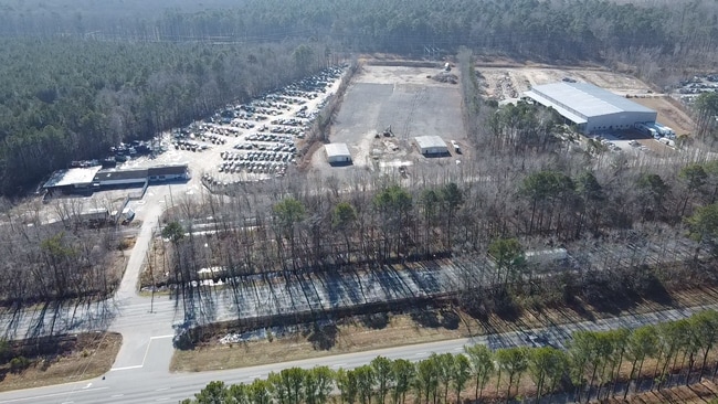
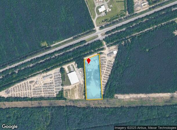
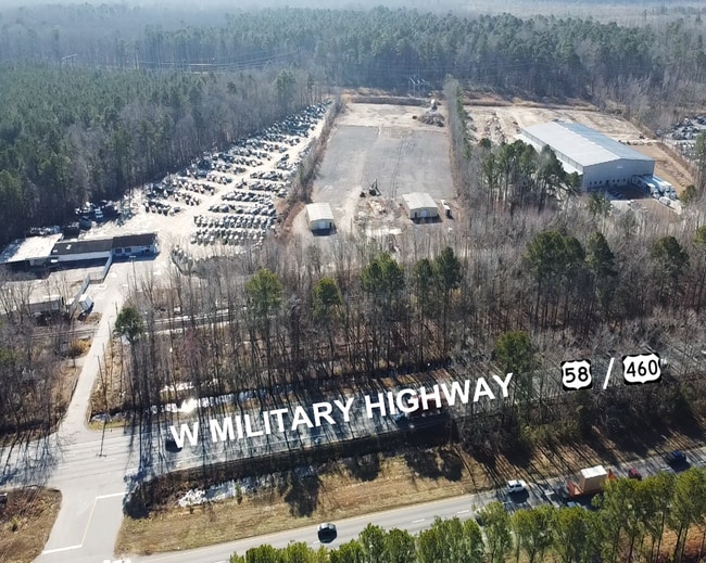
5411 W Military Hwy
0210000000014
South Military Hwy Corridor
Autorepair
PAR A-2 J R TURNER PROP 8 AC
X
Chesapeake
5100340019D
Virginia
2024
8 AC
2025
Cavalier
021301
Hampton Roads
2,320 SF
Virginia Beach-Norfolk-Newport News, VA-NC
DEMOGRAPHICS near 5411 W Military Hwy
1 Mile
3 Mile
5 Mile
2024 Total Population
3
4,930
36,535
2029 Population
3
5,087
38,548
Pop Growth 2024-2029
0.00%
+ 3.18%
+ 5.51%
Average Age
0
39
39
2024 Total Households
1
1,641
13,176
HH Growth 2024-2029
0.00%
+ 3.29%
+ 5.47%
Median Household Inc
$0
$145,017
$98,100
Avg Household Size
.00
3.00
2.70
2024 Avg HH Vehicles
.00
3.00
2.00
Median Home Value
$0
$425,507
$298,706
Median Year Built
0
1993
1993
Nearby Places
Map Layers
Map Styles
 Street
 Aerial
- Restaurants
- Banks
- Shops
- Fitness
- Groceries
PUBLIC TRANSPORTATION
AIRPORT
Norfolk International
DRIVE
WALK
Distance
Norfolk International
31 min
18.5 mi
Newport News/Williamsburg International
DRIVE
WALK
Distance
Newport News/Williamsburg International
45 min
32.9 mi
Freight Ports
Virginia Port Authority - Portsmouth
DRIVE
WALK
Distance
Virginia Port Authority - Portsmouth
20 min
11.4 mi
SALE & LEASE HISTORY
LISTING DATE
SALE/LEASE

Jul 08, 2022
For Lease
Feb 08, 2024
For Lease
Nearby Properties
Address
Land Use
TOTAL SIZE
Lot Size
Zoning
Address
Land Use
TOTAL SIZE
Lot Size
Zoning
3,817,119 SF
87.24 AC
HEAVY INDU
Address
Land Use
TOTAL SIZE
Lot Size
Zoning
30,746.62 AC
CONSERVATI
Address
Land Use
TOTAL SIZE
Lot Size
Zoning
206,652 SF
64.32 AC
A1: AGRICU
Address
Land Use
TOTAL SIZE
Lot Size
Zoning
12,715 SF
44.52 AC
A1: AGRICU
Address
Land Use
TOTAL SIZE
Lot Size
Zoning
29,828 SF
230.23 AC
MULTI: MUL
Address
Land Use
TOTAL SIZE
Lot Size
Zoning
15,000 SF
3.52 AC
B2: GENERA
Address
Land Use
TOTAL SIZE
Lot Size
Zoning
64,192 SF
15.67 AC
HEAVY INDU
Address
Land Use
TOTAL SIZE
Lot Size
Zoning
24,739 SF
11.91 AC
R15S: RESI
Address
Land Use
TOTAL SIZE
Lot Size
Zoning
23,388 SF
8.88 AC
R15S: RESI
Address
Land Use
TOTAL SIZE
Lot Size
Zoning
536 SF
30.83 AC
RMF1: MULT
Address
Land Use
TOTAL SIZE
Lot Size
Zoning
20.26 AC
PUD: PLANN
Address
Land Use
TOTAL SIZE
Lot Size
Zoning
30.31 AC
HEAVY INDU
Address
Land Use
TOTAL SIZE
Lot Size
Zoning
2,440 SF
10.20 AC
M1: LIGHT
Address
Land Use
TOTAL SIZE
Lot Size
Zoning
271.53 AC
A1: AGRICU
Address
Land Use
TOTAL SIZE
Lot Size
Zoning
8,300 SF
11.57 AC
M1: LIGHT
Address
Land Use
TOTAL SIZE
Lot Size
Zoning
12.56 AC
M1: LIGHT
Address
Land Use
TOTAL SIZE
Lot Size
Zoning
220.50 AC
PUD: PLANN
Address
Land Use
TOTAL SIZE
Lot Size
Zoning
3,290 SF
5 AC
AC: ASSEMB
Address
Land Use
TOTAL SIZE
Lot Size
Zoning
6.09 AC
PUD: PLANN
Address
Land Use
TOTAL SIZE
Lot Size
Zoning
109.03 AC
A1: AGRICU
Address
Land Use
TOTAL SIZE
Lot Size
Zoning
5,130 SF
11.66 AC
M1: LIGHT
Address
Land Use
TOTAL SIZE
Lot Size
Zoning
8,420 SF
3.30 AC
AC: ASSEMB
Address
Land Use
TOTAL SIZE
Lot Size
Zoning
54.62 AC
M1: LIGHT
Address
Land Use
TOTAL SIZE
Lot Size
Zoning
19,468 SF
1.64 AC
B3: HIGHWA
Address
Land Use
TOTAL SIZE
Lot Size
Zoning
4.88 AC
PUD: PLANN
Address
Land Use
TOTAL SIZE
Lot Size
Zoning
9,110 SF
0.50 AC
R12S: RESI
The World's #1 Commercial Real Estate Marketplace
Connect with us
© 2025 CoStar Group
The information above has been obtained from sources believed reliable. While we do not doubt its accuracy we have not verified it and make no guarantee, warranty or representation about it. It is your responsibility to independently confirm its accuracy and completeness. Any projections, opinions, assumptions, or estimates used are for example only and do not represent the current or future performance of the property. The value of this transaction to you depends on tax and other factors which should be evaluated by your tax, financial, and legal advisors. You and your advisors should conduct a careful, independent investigation of the property to determine to your satisfaction the suitability of the property for your needs.