Property Record
5412 Us Highway 70 E, Durham, NC 27705
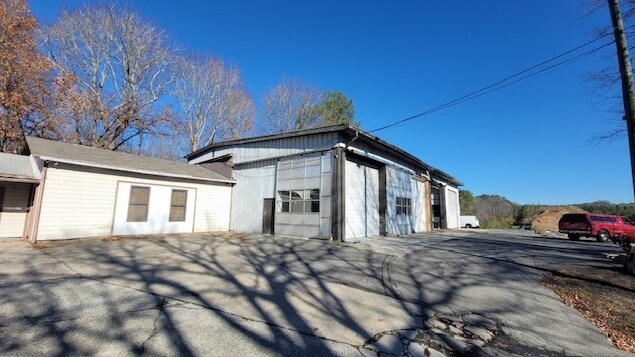

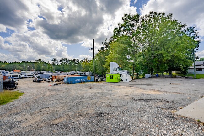
Property Detail
5412 Us Highway 70 E
Durham-Chapel Hill, NC
MAJ S/S I-85 P91/125
9893827318
ORANGE
Commercialnec
North Carolina
2025
16.70 AC
2025
Orange County
001706
Raleigh/Durham
6,156 SF
NEARBY LISTINGS FOR SALE OR LEASE
-
-
View all Durham listings for lease on LoopNet.com
DEMOGRAPHICS near 5412 Us Highway 70 E
1 mile
3 mile
5 mile
2025 Total Population
1,082
14,149
66,604
2030 Population
1,114
14,722
69,611
Pop Growth 2025-2030
+ 2.96%
+ 4.05%
+ 4.51%
Average Age
41
42
40
2025 Total Households
391
5,998
27,646
HH Growth 2025-2030
+ 3.32%
+ 4.37%
+ 5.07%
Median Household Inc
$68,571
$114,021
$88,898
Avg Household Size
2.50
2.30
2.20
2025 Avg HH Vehicles
2.00
2.00
2.00
Median Home Value
$254,999
$443,880
$476,661
Median Year Built
1983
1987
1989
Nearby Places
Map Layers
Map Styles
 Street
 Aerial
Layers
 Traffic
 Biking
Places
Listings with unknown addresses are not visible on the map
- Restaurants
- Banks
- Shops
- Fitness
- Groceries
PUBLIC TRANSPORTATION
COMMUTER RAIL
Durham Amtrak Station (Carolinian - Amtrak, Piedmont - Amtrak)
Drive
Walk
Distance
Durham Amtrak Station (Carolinian - Amtrak, Piedmont - Amtrak)
14 min
8.5 mi
AIRPORT
Raleigh-Durham International
Drive
Walk
Distance
Raleigh-Durham International
33 min
22.6 mi
Freight Ports
Virginia Port Authority - Richmond
Drive
Walk
Distance
Virginia Port Authority - Richmond
175 min
153.1 mi
SALE & LEASE HISTORY
LISTING DATE
SALE/LEASE

Oct 20, 2023
For Lease
Apr 05, 2019
For Lease
Nearby Properties
Address
Land Use
TOTAL SIZE
Lot Size
Zoning
Address
Land Use
TOTAL SIZE
Lot Size
Zoning
9,318 SF
19.27 AC
RS-M
Address
Land Use
TOTAL SIZE
Lot Size
Zoning
20,508 SF
15.82 AC
RS-M
Address
Land Use
TOTAL SIZE
Lot Size
Zoning
141,352 SF
8.40 AC
IL
Address
Land Use
TOTAL SIZE
Lot Size
Zoning
1,050.17 AC
ARR1
Address
Land Use
TOTAL SIZE
Lot Size
Zoning
119,180 SF
14.95 AC
IL
Address
Land Use
TOTAL SIZE
Lot Size
Zoning
14,883 SF
53.71 AC
Address
Land Use
TOTAL SIZE
Lot Size
Zoning
82,175 SF
10.13 AC
IP
Address
Land Use
TOTAL SIZE
Lot Size
Zoning
91,650 SF
4.99 AC
IL
Address
Land Use
TOTAL SIZE
Lot Size
Zoning
28.88 AC
IL
Address
Land Use
TOTAL SIZE
Lot Size
Zoning
1,663 SF
6.29 AC
PDR 4.540
Address
Land Use
TOTAL SIZE
Lot Size
Zoning
46,605 SF
4.96 AC
CG
Address
Land Use
TOTAL SIZE
Lot Size
Zoning
54,102 SF
5.65 AC
CC(D)
Address
Land Use
TOTAL SIZE
Lot Size
Zoning
51,898 SF
7 AC
PDR 4.540
Address
Land Use
TOTAL SIZE
Lot Size
Zoning
42,156 SF
2.61 AC
IL
Address
Land Use
TOTAL SIZE
Lot Size
Zoning
37,676 SF
4.84 AC
RS-20
Address
Land Use
TOTAL SIZE
Lot Size
Zoning
28,040 SF
50.56 AC
R1
Address
Land Use
TOTAL SIZE
Lot Size
Zoning
82.01 AC
RS-20
Address
Land Use
TOTAL SIZE
Lot Size
Zoning
44,800 SF
4.98 AC
IL(D)
Address
Land Use
TOTAL SIZE
Lot Size
Zoning
30,000 SF
8.90 AC
Address
Land Use
TOTAL SIZE
Lot Size
Zoning
71,640 SF
6.51 AC
IL,IP
Address
Land Use
TOTAL SIZE
Lot Size
Zoning
30,406 SF
8.27 AC
IP
Address
Land Use
TOTAL SIZE
Lot Size
Zoning
67,400 SF
3.82 AC
IL(D)
Address
Land Use
TOTAL SIZE
Lot Size
Zoning
85,248 SF
7.90 AC
IP
Address
Land Use
TOTAL SIZE
Lot Size
Zoning
2,112 SF
158.61 AC
Address
Land Use
TOTAL SIZE
Lot Size
Zoning
55.36 AC
RR
Address
Land Use
TOTAL SIZE
Lot Size
Zoning
101.99 AC
ARPID
Address
Land Use
TOTAL SIZE
Lot Size
Zoning
29,622 SF
5.41 AC
PDR 4.540
Address
Land Use
TOTAL SIZE
Lot Size
Zoning
9,633 SF
2.70 AC
IL
Address
Land Use
TOTAL SIZE
Lot Size
Zoning
22,775 SF
5.52 AC
IP
Address
Land Use
TOTAL SIZE
Lot Size
Zoning
153.96 AC
AREDDR1
The World's #1 Commercial Real Estate Marketplace
Connect with us
© 2026 CoStar Group
The information above has been obtained from sources believed reliable. While we do not doubt its accuracy we have not verified it and make no guarantee, warranty or representation about it. It is your responsibility to independently confirm its accuracy and completeness. Any projections, opinions, assumptions, or estimates used are for example only and do not represent the current or future performance of the property. The value of this transaction to you depends on tax and other factors which should be evaluated by your tax, financial, and legal advisors. You and your advisors should conduct a careful, independent investigation of the property to determine to your satisfaction the suitability of the property for your needs.