Property Record
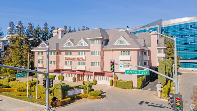
5415 Stevens Creek Blvd, Santa Clara, CA 95051


NEARBY LISTINGS FOR SALE OR LEASE
-
-
View all Santa Clara listings for sale on LoopNet.com
Property Detail
5415 Stevens Creek Blvd
San Jose-Sunnyvale-Santa Clara, CA
Craft Estate Partition
316-19-032
LOT C
Storebuilding
Santa Clara
X
California
06087C0050E
c
2024
0.92 AC
2025
San Jose South/Cupertino/Campbell
508102
South Bay/San Jose
40,929 SF
DEMOGRAPHICS near 5415 Stevens Creek Blvd
1 Mile
3 Mile
5 Mile
2024 Total Population
21,229
243,670
523,105
2029 Population
20,407
234,913
505,449
Pop Growth 2024-2029
(3.87%)
(3.59%)
(3.38%)
Average Age
39
40
40
2024 Total Households
7,091
86,265
191,480
HH Growth 2024-2029
(4.13%)
(3.85%)
(3.56%)
Median Household Inc
$196,072
$167,416
$159,980
Avg Household Size
2.90
2.80
2.60
2024 Avg HH Vehicles
2.00
2.00
2.00
Median Home Value
$1,140,542
$1,132,693
$1,128,233
Median Year Built
1969
1968
1969
Nearby Places
Map Layers
Map Styles
 Street
 Aerial
- Restaurants
- Banks
- Shops
- Fitness
- Groceries
PUBLIC TRANSPORTATION
COMMUTER RAIL
Lawrence (Caltrain - Caltrain (Caltrain))
DRIVE
WALK
Distance
Lawrence (Caltrain - Caltrain (Caltrain))
8 min
4.3 mi
Santa Clara (Caltrain - Caltrain (Caltrain))
DRIVE
WALK
Distance
Santa Clara (Caltrain - Caltrain (Caltrain))
11 min
5.3 mi
AIRPORT
Norman Y Mineta San Jose International
DRIVE
WALK
Distance
Norman Y Mineta San Jose International
13 min
6.0 mi
San Francisco International
DRIVE
WALK
Distance
San Francisco International
43 min
33.4 mi
Metro Oakland International
DRIVE
WALK
Distance
Metro Oakland International
52 min
41.2 mi
Nearby Properties
Address
Land Use
TOTAL SIZE
Lot Size
Zoning
Address
Land Use
TOTAL SIZE
Lot Size
Zoning
2,819,800 SF
91.85 AC
CU
Address
Land Use
TOTAL SIZE
Lot Size
Zoning
57,096 SF
58.04 AC
PM0
Address
Land Use
TOTAL SIZE
Lot Size
Zoning
196,100 SF
1.32 AC
PCMR
Address
Land Use
TOTAL SIZE
Lot Size
Zoning
833,956 SF
55.15 AC
PD
Address
Land Use
TOTAL SIZE
Lot Size
Zoning
304,000 SF
6.79 AC
PM0
Address
Land Use
TOTAL SIZE
Lot Size
Zoning
146,390 SF
9.04 AC
MP
Address
Land Use
TOTAL SIZE
Lot Size
Zoning
211,024 SF
9.92 AC
P
Address
Land Use
TOTAL SIZE
Lot Size
Zoning
32.93 AC
PC
Address
Land Use
TOTAL SIZE
Lot Size
Zoning
1,016,763 SF
7.63 AC
CC
Address
Land Use
TOTAL SIZE
Lot Size
Zoning
381,064 SF
20.42 AC
R322
Address
Land Use
TOTAL SIZE
Lot Size
Zoning
141,232 SF
7.98 AC
P(CGM
Address
Land Use
TOTAL SIZE
Lot Size
Zoning
174,405 SF
9.24 AC
ML
Address
Land Use
TOTAL SIZE
Lot Size
Zoning
161,956 SF
1.30 AC
PD
Address
Land Use
TOTAL SIZE
Lot Size
Zoning
3.40 AC
APD
Address
Land Use
TOTAL SIZE
Lot Size
Zoning
298,461 SF
5.45 AC
C3H
Address
Land Use
TOTAL SIZE
Lot Size
Zoning
4.75 AC
CP-PD
Address
Land Use
TOTAL SIZE
Lot Size
Zoning
346,857 SF
4.26 AC
PD-MC
Address
Land Use
TOTAL SIZE
Lot Size
Zoning
234,622 SF
1.89 AC
A(PD)
Address
Land Use
TOTAL SIZE
Lot Size
Zoning
295,569 SF
30.70 AC
SJ
Address
Land Use
TOTAL SIZE
Lot Size
Zoning
135,840 SF
1.54 AC
PD
Address
Land Use
TOTAL SIZE
Lot Size
Zoning
342,432 SF
3.99 AC
PD-MC
Address
Land Use
TOTAL SIZE
Lot Size
Zoning
77,375 SF
8.41 AC
P(ML)
Address
Land Use
TOTAL SIZE
Lot Size
Zoning
103,910 SF
6.68 AC
P
Address
Land Use
TOTAL SIZE
Lot Size
Zoning
279,360 SF
9.04 AC
R3
Address
Land Use
TOTAL SIZE
Lot Size
Zoning
161,375 SF
9.27 AC
PD
Address
Land Use
TOTAL SIZE
Lot Size
Zoning
4.04 AC
CT
Address
Land Use
TOTAL SIZE
Lot Size
Zoning
182,558 SF
0.84 AC
PD
Address
Land Use
TOTAL SIZE
Lot Size
Zoning
183,074 SF
0.84 AC
PD
Address
Land Use
TOTAL SIZE
Lot Size
Zoning
814,622 SF
14.57 AC
R3
Address
Land Use
TOTAL SIZE
Lot Size
Zoning
15.11 AC
PC
The World's #1 Commercial Real Estate Marketplace
Connect with us
© 2026 CoStar Group
The information above has been obtained from sources believed reliable. While we do not doubt its accuracy we have not verified it and make no guarantee, warranty or representation about it. It is your responsibility to independently confirm its accuracy and completeness. Any projections, opinions, assumptions, or estimates used are for example only and do not represent the current or future performance of the property. The value of this transaction to you depends on tax and other factors which should be evaluated by your tax, financial, and legal advisors. You and your advisors should conduct a careful, independent investigation of the property to determine to your satisfaction the suitability of the property for your needs.