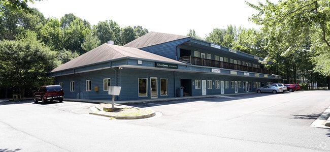
Property Record
5419 Deale Churchton Rd, Churchton, MD 20733


Current Lease Availabilities
NEARBY LISTINGS FOR SALE OR LEASE
-
-
View all Churchton listings for lease on LoopNet.com
Property Detail
5419 Deale Churchton Rd
07-000-00044555
Churchton
Regionalshoppingcenterormallwithanchorstore
1.20 ACRES CHURCHTON
X
Anne Arundel
24003C0316F
Maryland
2024
1.20 AC
2025
Southern Anne Arundel
707002
Baltimore
14,400 SF
Baltimore-Columbia-Towson, MD
DEMOGRAPHICS near 5419 Deale Churchton Rd
1 Mile
3 Mile
5 Mile
2024 Total Population
1,378
10,981
15,281
2029 Population
1,419
11,286
15,649
Pop Growth 2024-2029
+ 2.98%
+ 2.78%
+ 2.41%
Average Age
43
43
44
2024 Total Households
541
4,352
6,029
HH Growth 2024-2029
+ 2.96%
+ 2.80%
+ 2.47%
Median Household Inc
$138,701
$121,049
$117,496
Avg Household Size
2.50
2.50
2.50
2024 Avg HH Vehicles
2.00
2.00
2.00
Median Home Value
$393,004
$395,570
$441,391
Median Year Built
1980
1979
1978
Nearby Places
Map Layers
Map Styles
 Street
 Aerial
- Restaurants
- Banks
- Shops
- Fitness
- Groceries
PUBLIC TRANSPORTATION
AIRPORT
Ronald Reagan Washington Ntl
DRIVE
WALK
Distance
Ronald Reagan Washington Ntl
55 min
34.0 mi
Baltimore/Washington International Thurgood Marshall
DRIVE
WALK
Distance
Baltimore/Washington International Thurgood Marshall
54 min
35.7 mi
Freight Ports
Port of Baltimore
DRIVE
WALK
Distance
Port of Baltimore
60 min
40.9 mi
Nearby Properties
Address
Land Use
TOTAL SIZE
Lot Size
Zoning
Address
Land Use
TOTAL SIZE
Lot Size
Zoning
69,762 SF
61.73 AC
Address
Land Use
TOTAL SIZE
Lot Size
Zoning
65,982 SF
17.03 AC
R1
Address
Land Use
TOTAL SIZE
Lot Size
Zoning
8.38 AC
R1
Address
Land Use
TOTAL SIZE
Lot Size
Zoning
13,024 SF
5.51 AC
MC
Address
Land Use
TOTAL SIZE
Lot Size
Zoning
2,687 SF
2.82 AC
MB
Address
Land Use
TOTAL SIZE
Lot Size
Zoning
33,552 SF
3.77 AC
C3
Address
Land Use
TOTAL SIZE
Lot Size
Zoning
17.43 AC
R5
Address
Land Use
TOTAL SIZE
Lot Size
Zoning
9,906 SF
1.04 AC
MC
Address
Land Use
TOTAL SIZE
Lot Size
Zoning
15,106 SF
13.34 AC
MC
Address
Land Use
TOTAL SIZE
Lot Size
Zoning
15,166 SF
7.02 AC
C3
Address
Land Use
TOTAL SIZE
Lot Size
Zoning
15.77 AC
C1
Address
Land Use
TOTAL SIZE
Lot Size
Zoning
13,864 SF
2.40 AC
R5
Address
Land Use
TOTAL SIZE
Lot Size
Zoning
31,817 SF
5.51 AC
W2
Address
Land Use
TOTAL SIZE
Lot Size
Zoning
9,240 SF
1.49 AC
C3
Address
Land Use
TOTAL SIZE
Lot Size
Zoning
2,484 SF
396.53 AC
OS
Address
Land Use
TOTAL SIZE
Lot Size
Zoning
11,859 SF
3.22 AC
R1
Address
Land Use
TOTAL SIZE
Lot Size
Zoning
9,900 SF
44.58 AC
OS
Address
Land Use
TOTAL SIZE
Lot Size
Zoning
7,824 SF
2.98 AC
MA3
Address
Land Use
TOTAL SIZE
Lot Size
Zoning
1,477 SF
2.67 AC
W2
Address
Land Use
TOTAL SIZE
Lot Size
Zoning
11,483 SF
5.20 AC
C3
Address
Land Use
TOTAL SIZE
Lot Size
Zoning
9,324 SF
3.03 AC
R2
Address
Land Use
TOTAL SIZE
Lot Size
Zoning
9,840 SF
1.84 AC
C3
Address
Land Use
TOTAL SIZE
Lot Size
Zoning
2,052 SF
2.48 AC
W2
Address
Land Use
TOTAL SIZE
Lot Size
Zoning
11,416 SF
2.89 AC
R5
Address
Land Use
TOTAL SIZE
Lot Size
Zoning
11,352 SF
9.03 AC
R2
Address
Land Use
TOTAL SIZE
Lot Size
Zoning
5,108 SF
0.60 AC
MB
Address
Land Use
TOTAL SIZE
Lot Size
Zoning
19,372 SF
2.79 AC
C4
Address
Land Use
TOTAL SIZE
Lot Size
Zoning
18,270 SF
3.75 AC
MC
Address
Land Use
TOTAL SIZE
Lot Size
Zoning
3,272 SF
0.75 AC
MA2
Address
Land Use
TOTAL SIZE
Lot Size
Zoning
5,596 SF
2.62 AC
R1
The World's #1 Commercial Real Estate Marketplace
Connect with us
© 2026 CoStar Group
The information above has been obtained from sources believed reliable. While we do not doubt its accuracy we have not verified it and make no guarantee, warranty or representation about it. It is your responsibility to independently confirm its accuracy and completeness. Any projections, opinions, assumptions, or estimates used are for example only and do not represent the current or future performance of the property. The value of this transaction to you depends on tax and other factors which should be evaluated by your tax, financial, and legal advisors. You and your advisors should conduct a careful, independent investigation of the property to determine to your satisfaction the suitability of the property for your needs.