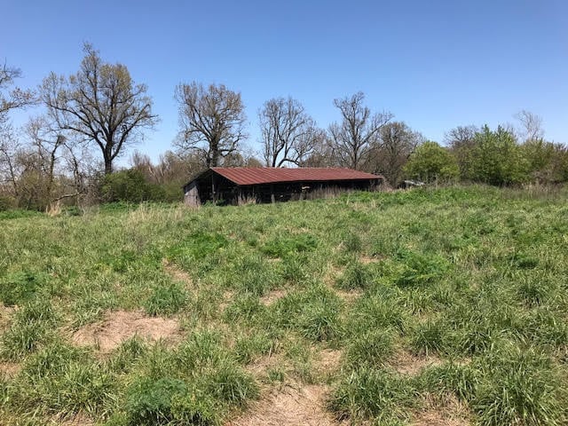
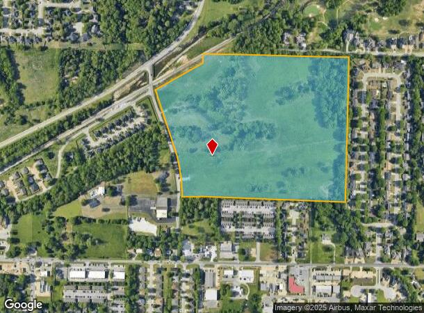
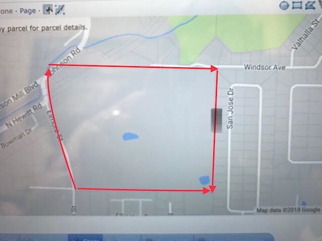
Property Record
5419 Elmore St, Johnson, AR 72741
NEARBY LISTINGS FOR SALE OR LEASE
-
-
-
No Photo
-
-
-
-
-
-
-
-
-
-
-
-
-
-
-
-
-
View all Johnson listings for sale on LoopNet.com
Property Detail
5419 Elmore St
785-18032-000
Johnson Outlots
Agriculturalland
PT NE NE 7.32 AC & PT NE NE .92 AC & PT NW NW 23-17-30 39.78 AC FURTHER DESCRIBED FROM 2024-10641 AS: PART OF THE NORTHWEST Q
AE
Washington
05143C0070G
Arkansas
2025
48.02 AC
2025
Greater Springdale
010511
Fayetteville/Springdale/Rogers
1,780 SF
Fayetteville-Springdale-Rogers, AR-MO
DEMOGRAPHICS near 5419 Elmore St
1 Mile
3 Mile
5 Mile
2024 Total Population
6,468
47,224
143,028
2029 Population
7,042
51,458
156,609
Pop Growth 2024-2029
+ 8.87%
+ 8.97%
+ 9.50%
Average Age
38
37
35
2024 Total Households
2,721
19,104
53,965
HH Growth 2024-2029
+ 8.97%
+ 9.24%
+ 9.72%
Median Household Inc
$78,675
$63,794
$64,000
Avg Household Size
2.40
2.40
2.50
2024 Avg HH Vehicles
2.00
2.00
2.00
Median Home Value
$238,448
$246,180
$247,582
Median Year Built
1997
1993
1993
Nearby Places
Map Layers
Map Styles
 Street
 Aerial
- Restaurants
- Banks
- Shops
- Fitness
- Groceries
PUBLIC TRANSPORTATION
AIRPORT
Northwest Arkansas Ntl
DRIVE
WALK
Distance
Northwest Arkansas Ntl
35 min
16.5 mi
Freight Ports
Tulsa Port of Inola
DRIVE
WALK
Distance
Tulsa Port of Inola
104 min
87.9 mi
SALE & LEASE HISTORY
LISTING DATE
SALE/LEASE

May 29, 2018
For Sale
Mar 14, 2019
For Sale
Aug 06, 2021
For Sale
Nearby Properties
Address
Land Use
TOTAL SIZE
Lot Size
Zoning
Address
Land Use
TOTAL SIZE
Lot Size
Zoning
132,060 SF
8 AC
Address
Land Use
TOTAL SIZE
Lot Size
Zoning
167,116 SF
41.39 AC
I1
Address
Land Use
TOTAL SIZE
Lot Size
Zoning
153,698 SF
14.10 AC
C2
Address
Land Use
TOTAL SIZE
Lot Size
Zoning
181,734 SF
21.02 AC
Address
Land Use
TOTAL SIZE
Lot Size
Zoning
481,800 SF
40 AC
Address
Land Use
TOTAL SIZE
Lot Size
Zoning
23,707 SF
15.45 AC
R2
Address
Land Use
TOTAL SIZE
Lot Size
Zoning
15,347 SF
6.27 AC
Address
Land Use
TOTAL SIZE
Lot Size
Zoning
238,168 SF
Address
Land Use
TOTAL SIZE
Lot Size
Zoning
437,349 SF
40.29 AC
Address
Land Use
TOTAL SIZE
Lot Size
Zoning
106,141 SF
2.82 AC
Address
Land Use
TOTAL SIZE
Lot Size
Zoning
50,708 SF
1.69 AC
C2
Address
Land Use
TOTAL SIZE
Lot Size
Zoning
232,212 SF
10.31 AC
Address
Land Use
TOTAL SIZE
Lot Size
Zoning
305,272 SF
9.66 AC
R2
Address
Land Use
TOTAL SIZE
Lot Size
Zoning
121,758 SF
20.54 AC
Address
Land Use
TOTAL SIZE
Lot Size
Zoning
81,000 SF
7.01 AC
Address
Land Use
TOTAL SIZE
Lot Size
Zoning
341,266 SF
17.61 AC
Address
Land Use
TOTAL SIZE
Lot Size
Zoning
78,374 SF
8.79 AC
Address
Land Use
TOTAL SIZE
Lot Size
Zoning
567,022 SF
88.88 AC
C2
Address
Land Use
TOTAL SIZE
Lot Size
Zoning
6,798 SF
10.56 AC
Address
Land Use
TOTAL SIZE
Lot Size
Zoning
41,952 SF
19.26 AC
Address
Land Use
TOTAL SIZE
Lot Size
Zoning
19,805 SF
0.35 AC
R0
Address
Land Use
TOTAL SIZE
Lot Size
Zoning
106,961 SF
8.56 AC
Address
Land Use
TOTAL SIZE
Lot Size
Zoning
178,014 SF
6.43 AC
Address
Land Use
TOTAL SIZE
Lot Size
Zoning
117,690 SF
2.38 AC
Address
Land Use
TOTAL SIZE
Lot Size
Zoning
261,670 SF
16.72 AC
R2
Address
Land Use
TOTAL SIZE
Lot Size
Zoning
176,204 SF
7.57 AC
Address
Land Use
TOTAL SIZE
Lot Size
Zoning
217,873 SF
24.10 AC
C2
Address
Land Use
TOTAL SIZE
Lot Size
Zoning
4,941 SF
10.87 AC
Address
Land Use
TOTAL SIZE
Lot Size
Zoning
193,140 SF
21.31 AC
Address
Land Use
TOTAL SIZE
Lot Size
Zoning
64,824 SF
15.82 AC
C2
The World's #1 Commercial Real Estate Marketplace
Connect with us
© 2025 CoStar Group
The information above has been obtained from sources believed reliable. While we do not doubt its accuracy we have not verified it and make no guarantee, warranty or representation about it. It is your responsibility to independently confirm its accuracy and completeness. Any projections, opinions, assumptions, or estimates used are for example only and do not represent the current or future performance of the property. The value of this transaction to you depends on tax and other factors which should be evaluated by your tax, financial, and legal advisors. You and your advisors should conduct a careful, independent investigation of the property to determine to your satisfaction the suitability of the property for your needs.