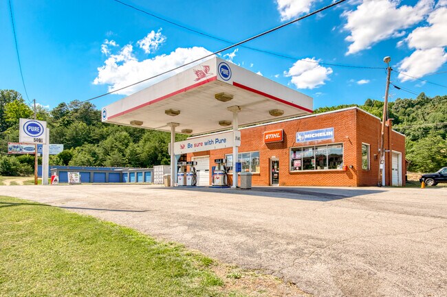
Property Record
5419 Virginia Ave, Pembroke, VA 24136

NEARBY LISTINGS FOR SALE OR LEASE
-
-
View all Pembroke listings for sale on LoopNet.com
Property Detail
5419 Virginia Ave
41-80B
SNIDOW
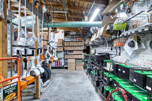
Servicestation
Giles
X
Virginia
51071C0208C
0.50 AC
2025
Blacksburg & Wytheville
2025
Other Market Areas
930200
Blacksburg-Christiansburg-Radford, VA
3,030 SF
DEMOGRAPHICS near 5419 Virginia Ave
1 Mile
3 Mile
5 Mile
2024 Total Population
279
3,232
7,837
2029 Population
275
3,172
7,692
Pop Growth 2024-2029
(1.43%)
(1.86%)
(1.85%)
Average Age
45
44
44
2024 Total Households
121
1,393
3,371
HH Growth 2024-2029
(1.65%)
(1.79%)
(1.81%)
Median Household Inc
$64,853
$64,772
$62,007
Avg Household Size
2.30
2.30
2.30
2024 Avg HH Vehicles
2.00
2.00
2.00
Median Home Value
$157,575
$156,735
$158,143
Median Year Built
1976
1975
1973
Nearby Places
Map Layers
Map Styles
 Street
 Aerial
- Restaurants
- Banks
- Shops
- Fitness
- Groceries
SALE & LEASE HISTORY
LISTING DATE
SALE/LEASE

Jul 08, 2022
For Sale
Nearby Properties
Address
Land Use
TOTAL SIZE
Lot Size
Zoning
Address
Land Use
TOTAL SIZE
Lot Size
Zoning
88,120 SF
23.50 AC
RRA1
Address
Land Use
TOTAL SIZE
Lot Size
Zoning
2,036 SF
25.44 AC
RRA1
Address
Land Use
TOTAL SIZE
Lot Size
Zoning
110,592 SF
10.15 AC
R-6
Address
Land Use
TOTAL SIZE
Lot Size
Zoning
4.56 AC
RRA1
Address
Land Use
TOTAL SIZE
Lot Size
Zoning
3,780 SF
503.58 AC
AI1
Address
Land Use
TOTAL SIZE
Lot Size
Zoning
12,300 SF
6.53 AC
RRA1
Address
Land Use
TOTAL SIZE
Lot Size
Zoning
25,164 SF
3.30 AC
PR-2
Address
Land Use
TOTAL SIZE
Lot Size
Zoning
20,024 SF
20.36 AC
A-1
Address
Land Use
TOTAL SIZE
Lot Size
Zoning
3,462 SF
39.25 AC
RRA1
Address
Land Use
TOTAL SIZE
Lot Size
Zoning
34,800 SF
4.17 AC
PB-1
Address
Land Use
TOTAL SIZE
Lot Size
Zoning
50,332 SF
5.50 AC
R-1
Address
Land Use
TOTAL SIZE
Lot Size
Zoning
4,513 SF
1.23 AC
T
Address
Land Use
TOTAL SIZE
Lot Size
Zoning
Address
Land Use
TOTAL SIZE
Lot Size
Zoning
6,148 SF
1.24 AC
T
Address
Land Use
TOTAL SIZE
Lot Size
Zoning
4,970 SF
1.82 AC
R-2
Address
Land Use
TOTAL SIZE
Lot Size
Zoning
3,495 SF
1.02 AC
R-6
Address
Land Use
TOTAL SIZE
Lot Size
Zoning
8,454 SF
0.95 AC
R-6
Address
Land Use
TOTAL SIZE
Lot Size
Zoning
Address
Land Use
TOTAL SIZE
Lot Size
Zoning
4,742 SF
1.01 AC
RRA1
Address
Land Use
TOTAL SIZE
Lot Size
Zoning
22,000 SF
2.43 AC
RRA1
Address
Land Use
TOTAL SIZE
Lot Size
Zoning
10,176 SF
1.41 AC
T
Address
Land Use
TOTAL SIZE
Lot Size
Zoning
7,040 SF
68.64 AC
RRA1
Address
Land Use
TOTAL SIZE
Lot Size
Zoning
5,024 SF
1.33 AC
PB-2
Address
Land Use
TOTAL SIZE
Lot Size
Zoning
8,190 SF
0.80 AC
PR-2
Address
Land Use
TOTAL SIZE
Lot Size
Zoning
4,228 SF
0.66 AC
RRA1
Address
Land Use
TOTAL SIZE
Lot Size
Zoning
47.02 AC
RRA1
Address
Land Use
TOTAL SIZE
Lot Size
Zoning
4,100 SF
1.01 AC
R-6
Address
Land Use
TOTAL SIZE
Lot Size
Zoning
6,802 SF
1.08 AC
RRA1
Address
Land Use
TOTAL SIZE
Lot Size
Zoning
90.79 AC
RRA1
Address
Land Use
TOTAL SIZE
Lot Size
Zoning
10,589 SF
1.87 AC
R-1
The World's #1 Commercial Real Estate Marketplace
Connect with us
© 2026 CoStar Group
The information above has been obtained from sources believed reliable. While we do not doubt its accuracy we have not verified it and make no guarantee, warranty or representation about it. It is your responsibility to independently confirm its accuracy and completeness. Any projections, opinions, assumptions, or estimates used are for example only and do not represent the current or future performance of the property. The value of this transaction to you depends on tax and other factors which should be evaluated by your tax, financial, and legal advisors. You and your advisors should conduct a careful, independent investigation of the property to determine to your satisfaction the suitability of the property for your needs.