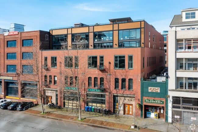
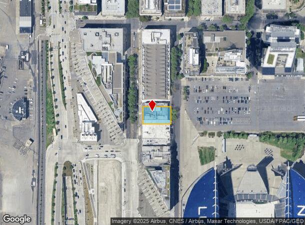
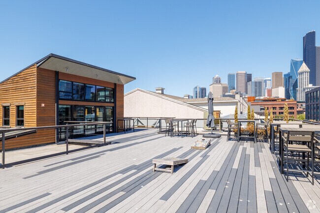
Property Record
542 1St Ave S, Seattle, WA 98104

Current Lease Availabilities
NEARBY LISTINGS FOR SALE OR LEASE
Property Detail
542 1St Ave S
Seattle-Tacoma-Bellevue, WA
Seattle Tide Lds Bl 01-376
766620-6851
SEATTLE TIDE LDS S 32.5 FT OF 7 & N 57.5 FT OF 8 & STRIP OF LAND S OF & ADJ S LN OF N 57.5 FT OF SD LOT 8 BEG SW COR OF N 57.5 FT OF LOT 8 TH E TO W MGN OF OCCIDENTAL AVE TH WLY TO PT .18 FT S OF BEG TH N TO BEG
Officebuilding
King
X
Washington
53033C0630G
7-8
2025
0.31 AC
2024
Pioneer Square/Waterfront
009300
Seattle/Puget Sound
66,842 SF
DEMOGRAPHICS near 542 1St Ave S
1 Mile
3 Mile
5 Mile
2024 Total Population
34,694
247,264
474,273
2029 Population
36,251
253,211
482,682
Pop Growth 2024-2029
+ 4.49%
+ 2.41%
+ 1.77%
Average Age
41
39
38
2024 Total Households
19,226
136,734
234,014
HH Growth 2024-2029
+ 4.78%
+ 2.42%
+ 1.86%
Median Household Inc
$68,612
$109,379
$112,096
Avg Household Size
1.50
1.70
1.90
2024 Avg HH Vehicles
1.00
1.00
1.00
Median Home Value
$859,802
$897,393
$909,164
Median Year Built
1996
1992
1983
Nearby Places
Map Layers
Map Styles
 Street
 Aerial
- Restaurants
- Banks
- Shops
- Fitness
- Groceries
PUBLIC TRANSPORTATION
TRANSIT/SUBWAY
Occidental Mall (First Hill Streetcar - City of Seattle)
DRIVE
WALK
Distance
Occidental Mall (First Hill Streetcar - City of Seattle)
1 min
3 min
0.2 mi
Intl District Station Acrd & Tunnel Sta.-Bay C (LINK to Sea-Tac - Sound Transit, Lynnwood - Angle Lake - Sound Transit)
DRIVE
WALK
Distance
Intl District Station Acrd & Tunnel Sta.-Bay C (LINK to Sea-Tac - Sound Transit, Lynnwood - Angle Lake - Sound Transit)
1 min
8 min
0.4 mi
5Th & Jackson (First Hill Streetcar - City of Seattle)
DRIVE
WALK
Distance
5Th & Jackson (First Hill Streetcar - City of Seattle)
1 min
9 min
0.5 mi
International District/Chinatown (Central Link - Central Puget Sound Regional Transit Authority Rail (Link Light Rail/Sounder), LINK to Sea-Tac - Central Puget Sound Regional Transit Authority Rail (Link Light Rail/Sounder))
DRIVE
WALK
Distance
International District/Chinatown (Central Link - Central Puget Sound Regional Transit Authority Rail (Link Light Rail/Sounder), LINK to Sea-Tac - Central Puget Sound Regional Transit Authority Rail (Link Light Rail/Sounder))
1 min
9 min
0.5 mi
Pioneer Sq Sta Acrd & Tunnel Sta.-Bay C (LINK to Sea-Tac - Sound Transit, Lynnwood - Angle Lake - Sound Transit)
DRIVE
WALK
Distance
Pioneer Sq Sta Acrd & Tunnel Sta.-Bay C (LINK to Sea-Tac - Sound Transit, Lynnwood - Angle Lake - Sound Transit)
1 min
9 min
0.5 mi
COMMUTER RAIL
King Street (Seattle) Station (Everett - Seattle - Sound Transit, Seattle - Tacoma/Lakewood - Sound Transit, Sounder South Line - Sound Transit)
DRIVE
WALK
Distance
King Street (Seattle) Station (Everett - Seattle - Sound Transit, Seattle - Tacoma/Lakewood - Sound Transit, Sounder South Line - Sound Transit)
1 min
6 min
0.4 mi
AIRPORT
Seattle-Tacoma International
DRIVE
WALK
Distance
Seattle-Tacoma International
23 min
12.8 mi
Seattle Paine Field International
DRIVE
WALK
Distance
Seattle Paine Field International
36 min
24.4 mi
Freight Ports
Port of Seattle
DRIVE
WALK
Distance
Port of Seattle
7 min
3.1 mi
Nearby Properties
Address
Land Use
TOTAL SIZE
Lot Size
Zoning
Address
Land Use
TOTAL SIZE
Lot Size
Zoning
800,000 SF
8.57 AC
SM-UP 95 (
Address
Land Use
TOTAL SIZE
Lot Size
Zoning
2.84 AC
DMC 340/29
Address
Land Use
TOTAL SIZE
Lot Size
Zoning
793,990 SF
30.81 AC
UI U/85
Address
Land Use
TOTAL SIZE
Lot Size
Zoning
946,212 SF
1.58 AC
DMC 340/29
Address
Land Use
TOTAL SIZE
Lot Size
Zoning
686,722 SF
1.26 AC
SM-SLU 240
Address
Land Use
TOTAL SIZE
Lot Size
Zoning
36,864 SF
8.02 AC
SM-UP 95 (
Address
Land Use
TOTAL SIZE
Lot Size
Zoning
992,925 SF
4.28 AC
MIO-240-HR
Address
Land Use
TOTAL SIZE
Lot Size
Zoning
1,526,621 SF
1.36 AC
DOC1 U/450
Address
Land Use
TOTAL SIZE
Lot Size
Zoning
716,128 SF
1.41 AC
SM-SLU 175
Address
Land Use
TOTAL SIZE
Lot Size
Zoning
1,062,251 SF
1.47 AC
DOC2 500/3
Address
Land Use
TOTAL SIZE
Lot Size
Zoning
763,898 SF
2.03 AC
DOC2 500/3
Address
Land Use
TOTAL SIZE
Lot Size
Zoning
1,137,666 SF
2.07 AC
DOC1 U/450
Address
Land Use
TOTAL SIZE
Lot Size
Zoning
7,930 SF
4.14 AC
MIO-240-HR
Address
Land Use
TOTAL SIZE
Lot Size
Zoning
6,379 SF
127.60 AC
MML U/85
Address
Land Use
TOTAL SIZE
Lot Size
Zoning
1,128,575 SF
1.30 AC
DOC1 U/450
Address
Land Use
TOTAL SIZE
Lot Size
Zoning
615,000 SF
0.88 AC
DOC2 500/3
Address
Land Use
TOTAL SIZE
Lot Size
Zoning
861,221 SF
1.30 AC
DMC 340/29
Address
Land Use
TOTAL SIZE
Lot Size
Zoning
565,110 SF
29.11 AC
II U/85
Address
Land Use
TOTAL SIZE
Lot Size
Zoning
377,813 SF
1.65 AC
DOC2 500/3
Address
Land Use
TOTAL SIZE
Lot Size
Zoning
1,011,547 SF
0.35 AC
DOC1 U/450
Address
Land Use
TOTAL SIZE
Lot Size
Zoning
1,478,612 SF
0.80 AC
DOC2 500/3
Address
Land Use
TOTAL SIZE
Lot Size
Zoning
67,235 SF
0.45 AC
DOC2 500/3
Address
Land Use
TOTAL SIZE
Lot Size
Zoning
922,344 SF
1.33 AC
DRC 85-170
Address
Land Use
TOTAL SIZE
Lot Size
Zoning
413,982 SF
0.58 AC
DMC 340/29
Address
Land Use
TOTAL SIZE
Lot Size
Zoning
412,000 SF
1.27 AC
DOC1 U/450
Address
Land Use
TOTAL SIZE
Lot Size
Zoning
943,610 SF
1.24 AC
DOC1 U/450
Address
Land Use
TOTAL SIZE
Lot Size
Zoning
155,795 SF
7.89 AC
SM-UP 95 (
Address
Land Use
TOTAL SIZE
Lot Size
Zoning
411,654 SF
0.59 AC
DMC 240/29
The World's #1 Commercial Real Estate Marketplace
Connect with us
© 2025 CoStar Group
The information above has been obtained from sources believed reliable. While we do not doubt its accuracy we have not verified it and make no guarantee, warranty or representation about it. It is your responsibility to independently confirm its accuracy and completeness. Any projections, opinions, assumptions, or estimates used are for example only and do not represent the current or future performance of the property. The value of this transaction to you depends on tax and other factors which should be evaluated by your tax, financial, and legal advisors. You and your advisors should conduct a careful, independent investigation of the property to determine to your satisfaction the suitability of the property for your needs.