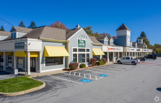
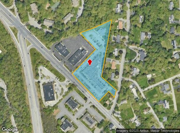
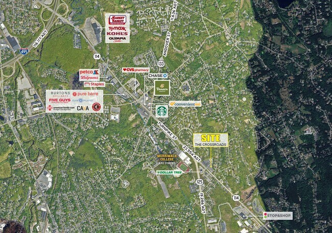
Property Record
550 Turnpike St, North Andover, MA 01845
Current Lease Availabilities
NEARBY LISTINGS FOR SALE OR LEASE
Property Detail
550 Turnpike St
Commercialnec
Essex
X
Massachusetts
25009C0236G
3.82 AC
2025
Lawrence/Andover
2025
Boston
253202
Boston-Cambridge-Newton, MA-NH
3,890 SF
NAND-000250-000001
DEMOGRAPHICS near 550 Turnpike St
1 Mile
3 Mile
5 Mile
2024 Total Population
8,566
60,544
165,175
2029 Population
8,557
60,157
162,745
Pop Growth 2024-2029
(0.11%)
(0.64%)
(1.47%)
Average Age
34
39
38
2024 Total Households
2,355
21,734
56,656
HH Growth 2024-2029
+ 0.13%
(0.64%)
(1.38%)
Median Household Inc
$130,546
$108,801
$80,314
Avg Household Size
2.70
2.60
2.80
2024 Avg HH Vehicles
2.00
2.00
2.00
Median Home Value
$724,228
$630,343
$553,090
Median Year Built
1974
1965
1963
Nearby Places
Map Layers
Map Styles
 Street
 Aerial
- Restaurants
- Banks
- Shops
- Fitness
- Groceries
PUBLIC TRANSPORTATION
COMMUTER RAIL
Andover (Haverhill Line - Massachusetts Bay Transportation Authority Commuter Rail (Purple Line))
DRIVE
WALK
Distance
Andover (Haverhill Line - Massachusetts Bay Transportation Authority Commuter Rail (Purple Line))
5 min
2.4 mi
Lawrence (Haverhill Line - Massachusetts Bay Transportation Authority Commuter Rail (Purple Line))
DRIVE
WALK
Distance
Lawrence (Haverhill Line - Massachusetts Bay Transportation Authority Commuter Rail (Purple Line))
8 min
3.5 mi
AIRPORT
General Edward Lawrence Logan International
DRIVE
WALK
Distance
General Edward Lawrence Logan International
39 min
27.1 mi
Manchester Boston Regional
DRIVE
WALK
Distance
Manchester Boston Regional
49 min
32.5 mi
Freight Ports
Port of Boston
DRIVE
WALK
Distance
Port of Boston
40 min
26.9 mi
Nearby Properties
Address
Land Use
TOTAL SIZE
Lot Size
Zoning
Address
Land Use
TOTAL SIZE
Lot Size
Zoning
102 AC
IA
Address
Land Use
TOTAL SIZE
Lot Size
Zoning
6,680 SF
84.07 AC
R2
Address
Land Use
TOTAL SIZE
Lot Size
Zoning
9,576 SF
56.95 AC
R3
Address
Land Use
TOTAL SIZE
Lot Size
Zoning
3,111 SF
42.18 AC
R5
Address
Land Use
TOTAL SIZE
Lot Size
Zoning
15,621 SF
34 AC
R5
Address
Land Use
TOTAL SIZE
Lot Size
Zoning
26.09 AC
R2
Address
Land Use
TOTAL SIZE
Lot Size
Zoning
16.56 AC
Address
Land Use
TOTAL SIZE
Lot Size
Zoning
314,278 SF
595.78 AC
SRB
Address
Land Use
TOTAL SIZE
Lot Size
Zoning
263.15 AC
SRB
Address
Land Use
TOTAL SIZE
Lot Size
Zoning
170,116 SF
11.14 AC
Address
Land Use
TOTAL SIZE
Lot Size
Zoning
8.59 AC
IS
Address
Land Use
TOTAL SIZE
Lot Size
Zoning
71,785 SF
29 AC
R4
Address
Land Use
TOTAL SIZE
Lot Size
Zoning
140,376 SF
2,026.22 AC
SRB
Address
Land Use
TOTAL SIZE
Lot Size
Zoning
7.13 AC
Address
Land Use
TOTAL SIZE
Lot Size
Zoning
8,738 SF
30.59 AC
R4
Address
Land Use
TOTAL SIZE
Lot Size
Zoning
0.13 AC
MU
Address
Land Use
TOTAL SIZE
Lot Size
Zoning
14 AC
SRB
Address
Land Use
TOTAL SIZE
Lot Size
Zoning
169,008 SF
33.35 AC
VC
Address
Land Use
TOTAL SIZE
Lot Size
Zoning
224.38 AC
SRB
Address
Land Use
TOTAL SIZE
Lot Size
Zoning
232,908 SF
12.74 AC
B3
Address
Land Use
TOTAL SIZE
Lot Size
Zoning
129,522 SF
20.22 AC
SRB
Address
Land Use
TOTAL SIZE
Lot Size
Zoning
215,739 SF
8.45 AC
IS
Address
Land Use
TOTAL SIZE
Lot Size
Zoning
26.60 AC
Address
Land Use
TOTAL SIZE
Lot Size
Zoning
3.44 AC
Address
Land Use
TOTAL SIZE
Lot Size
Zoning
7,344 SF
7.90 AC
Address
Land Use
TOTAL SIZE
Lot Size
Zoning
899 SF
11.92 AC
IS
Address
Land Use
TOTAL SIZE
Lot Size
Zoning
6,076 SF
13.56 AC
GB
Address
Land Use
TOTAL SIZE
Lot Size
Zoning
81,975 SF
9.37 AC
SRB
Address
Land Use
TOTAL SIZE
Lot Size
Zoning
146,728 SF
0.17 AC
MU
Address
Land Use
TOTAL SIZE
Lot Size
Zoning
72,528 SF
15 AC
R2
The World's #1 Commercial Real Estate Marketplace
Connect with us
© 2025 CoStar Group
The information above has been obtained from sources believed reliable. While we do not doubt its accuracy we have not verified it and make no guarantee, warranty or representation about it. It is your responsibility to independently confirm its accuracy and completeness. Any projections, opinions, assumptions, or estimates used are for example only and do not represent the current or future performance of the property. The value of this transaction to you depends on tax and other factors which should be evaluated by your tax, financial, and legal advisors. You and your advisors should conduct a careful, independent investigation of the property to determine to your satisfaction the suitability of the property for your needs.