Property Record
542 Capital Ave Sw, Battle Creek, MI 49015
NEARBY LISTINGS FOR SALE OR LEASE
Property Detail
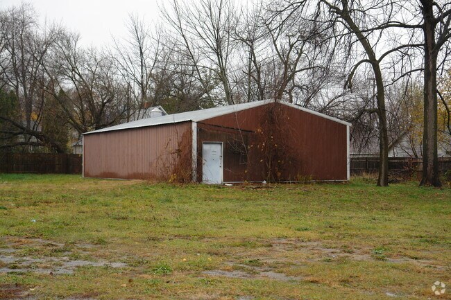
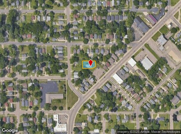
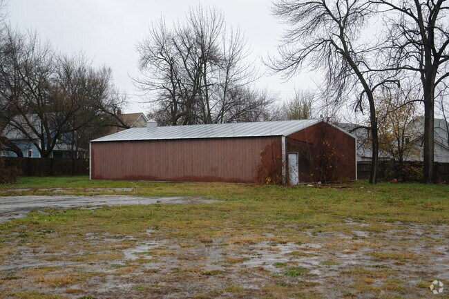
542 Capital Ave Sw
Battle Creek, MI
Assrs Rep Of Triora Add
8440-00-011-1
ASSRS RE-PLAT OF TRIORA ADD LOTS 10 & 11, EXC W 95 FT THEREOF, TOGETHER WITH 8-FT DRIVEWAY EASE, C/L OF WHICH IS A LI RNG PAR
Commercialnec
Calhoun
X
Michigan
26025C0187C
10-11
0
0.20 AC
2025
Battle Crk/W Calhoun Cnty
000500
West Michigan
1,818 SF
DEMOGRAPHICS near 542 Capital Ave Sw
1 Mile
3 Mile
5 Mile
2024 Total Population
9,780
49,572
77,746
2029 Population
9,756
49,148
77,015
Pop Growth 2024-2029
(0.25%)
(0.86%)
(0.94%)
Average Age
37
39
40
2024 Total Households
3,830
19,780
31,856
HH Growth 2024-2029
(0.34%)
(0.91%)
(0.96%)
Median Household Inc
$41,758
$47,408
$49,794
Avg Household Size
2.40
2.40
2.30
2024 Avg HH Vehicles
1.00
2.00
2.00
Median Home Value
$79,108
$99,699
$120,251
Median Year Built
1950
1953
1959
Nearby Places
Map Layers
Map Styles
 Street
 Aerial
- Restaurants
- Banks
- Shops
- Fitness
- Groceries
PUBLIC TRANSPORTATION
COMMUTER RAIL
DRIVE
WALK
Distance
3 min
1.3 mi
AIRPORT
Kalamazoo/Battle Creek International
DRIVE
WALK
Distance
Kalamazoo/Battle Creek International
34 min
22.4 mi
Nearby Properties
Address
Land Use
TOTAL SIZE
Lot Size
Zoning
Address
Land Use
TOTAL SIZE
Lot Size
Zoning
1,513,110 SF
108.07 AC
I2
Address
Land Use
TOTAL SIZE
Lot Size
Zoning
337,297 SF
18.85 AC
T4
Address
Land Use
TOTAL SIZE
Lot Size
Zoning
291,206 SF
18.98 AC
T4
Address
Land Use
TOTAL SIZE
Lot Size
Zoning
1,131,895 SF
26.46 AC
I1
Address
Land Use
TOTAL SIZE
Lot Size
Zoning
158,242 SF
28.01 AC
B1
Address
Land Use
TOTAL SIZE
Lot Size
Zoning
174,064 SF
T4
Address
Land Use
TOTAL SIZE
Lot Size
Zoning
52,764 SF
3.52 AC
AG
Address
Land Use
TOTAL SIZE
Lot Size
Zoning
131,048 SF
12.28 AC
R1A
Address
Land Use
TOTAL SIZE
Lot Size
Zoning
111,002 SF
AG
Address
Land Use
TOTAL SIZE
Lot Size
Zoning
134,482 SF
17.15 AC
MFR
Address
Land Use
TOTAL SIZE
Lot Size
Zoning
158,242 SF
25.25 AC
B1
Address
Land Use
TOTAL SIZE
Lot Size
Zoning
134,355 SF
5.35 AC
MFR
Address
Land Use
TOTAL SIZE
Lot Size
Zoning
150,018 SF
13.12 AC
MFR
Address
Land Use
TOTAL SIZE
Lot Size
Zoning
129,598 SF
0.62 AC
T5
Address
Land Use
TOTAL SIZE
Lot Size
Zoning
34,452 SF
1.12 AC
T4
Address
Land Use
TOTAL SIZE
Lot Size
Zoning
106,703 SF
9.69 AC
MFR
Address
Land Use
TOTAL SIZE
Lot Size
Zoning
49,412 SF
Address
Land Use
TOTAL SIZE
Lot Size
Zoning
188,388 SF
18.15 AC
T3
Address
Land Use
TOTAL SIZE
Lot Size
Zoning
111,744 SF
9.75 AC
RM-1
Address
Land Use
TOTAL SIZE
Lot Size
Zoning
52,109 SF
6.46 AC
MFR
Address
Land Use
TOTAL SIZE
Lot Size
Zoning
53,501 SF
7.34 AC
B1
Address
Land Use
TOTAL SIZE
Lot Size
Zoning
98,360 SF
0.31 AC
T5
Address
Land Use
TOTAL SIZE
Lot Size
Zoning
50,000 SF
8.48 AC
R-2
Address
Land Use
TOTAL SIZE
Lot Size
Zoning
82,210 SF
0.29 AC
T5
Address
Land Use
TOTAL SIZE
Lot Size
Zoning
149,939 SF
28.09 AC
I1
Address
Land Use
TOTAL SIZE
Lot Size
Zoning
350,559 SF
18.76 AC
I2
Address
Land Use
TOTAL SIZE
Lot Size
Zoning
45,864 SF
7.84 AC
B1
Address
Land Use
TOTAL SIZE
Lot Size
Zoning
21,200 SF
3.29 AC
B2
Address
Land Use
TOTAL SIZE
Lot Size
Zoning
Address
Land Use
TOTAL SIZE
Lot Size
Zoning
394,832 SF
48.36 AC
I1
The World's #1 Commercial Real Estate Marketplace
Connect with us
© 2025 CoStar Group
The information above has been obtained from sources believed reliable. While we do not doubt its accuracy we have not verified it and make no guarantee, warranty or representation about it. It is your responsibility to independently confirm its accuracy and completeness. Any projections, opinions, assumptions, or estimates used are for example only and do not represent the current or future performance of the property. The value of this transaction to you depends on tax and other factors which should be evaluated by your tax, financial, and legal advisors. You and your advisors should conduct a careful, independent investigation of the property to determine to your satisfaction the suitability of the property for your needs.