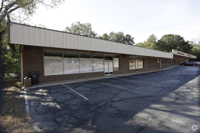
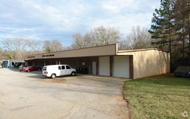
Property Record
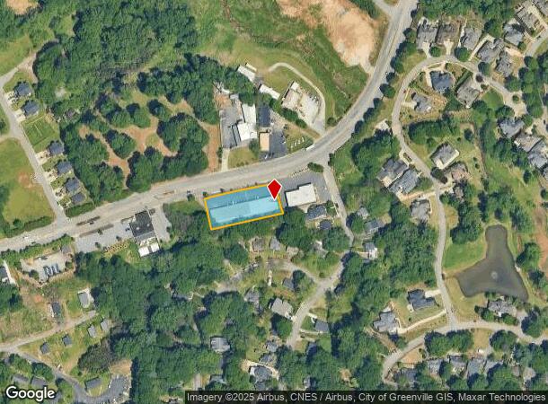
544 Rutherford Rd, Greenville, SC 29609
NEARBY LISTINGS FOR SALE OR LEASE
Property Detail
544 Rutherford Rd
Greenville-Anderson-Mauldin, SC
Druid Hills
0176.00-03-136.00
PTB
Publicstorage
Greenville
X
South Carolina
45045C0382E
136.00
2024
0.66 AC
2024
West Side Greenville
001102
Greenville/Spartanburg
DEMOGRAPHICS near 544 Rutherford Rd
1 Mile
3 Mile
5 Mile
2024 Total Population
10,314
84,582
175,941
2029 Population
11,516
94,274
195,087
Pop Growth 2024-2029
+ 11.65%
+ 11.46%
+ 10.88%
Average Age
38
38
39
2024 Total Households
4,286
36,258
75,072
HH Growth 2024-2029
+ 11.85%
+ 11.75%
+ 11.06%
Median Household Inc
$61,624
$52,137
$56,664
Avg Household Size
2.20
2.20
2.20
2024 Avg HH Vehicles
2.00
2.00
2.00
Median Home Value
$358,171
$260,413
$256,445
Median Year Built
1975
1978
1979
Nearby Places
- Restaurants
- Banks
- Shops
- Fitness
- Groceries
PUBLIC TRANSPORTATION
COMMUTER RAIL
Greenville Amtrak Station (Crescent - Amtrak)
DRIVE
WALK
Distance
Greenville Amtrak Station (Crescent - Amtrak)
4 min
1.7 mi
AIRPORT
Greenville Spartanburg International
DRIVE
WALK
Distance
Greenville Spartanburg International
26 min
15.7 mi
Freight Ports
North Charleston Terminal
DRIVE
WALK
Distance
North Charleston Terminal
233 min
206.4 mi
SALE & LEASE HISTORY
LISTING DATE
SALE/LEASE

Oct 27, 2016
For Sale
Nearby Properties
Address
Land Use
TOTAL SIZE
Lot Size
Zoning
Address
Land Use
TOTAL SIZE
Lot Size
Zoning
22.97 AC
R12
Address
Land Use
TOTAL SIZE
Lot Size
Zoning
14.41 AC
RM2
Address
Land Use
TOTAL SIZE
Lot Size
Zoning
11.99 AC
RM2
Address
Land Use
TOTAL SIZE
Lot Size
Zoning
11.82 AC
RM2
Address
Land Use
TOTAL SIZE
Lot Size
Zoning
8.94 AC
RM2
Address
Land Use
TOTAL SIZE
Lot Size
Zoning
1.01 AC
C4
Address
Land Use
TOTAL SIZE
Lot Size
Zoning
0.39 AC
C4
Address
Land Use
TOTAL SIZE
Lot Size
Zoning
9.13 AC
RM2
Address
Land Use
TOTAL SIZE
Lot Size
Zoning
10 AC
RM
Address
Land Use
TOTAL SIZE
Lot Size
Zoning
10.59 AC
RM2
Address
Land Use
TOTAL SIZE
Lot Size
Zoning
28.88 AC
RM
Address
Land Use
TOTAL SIZE
Lot Size
Zoning
28.72 AC
C3
Address
Land Use
TOTAL SIZE
Lot Size
Zoning
5.61 AC
RM2
Address
Land Use
TOTAL SIZE
Lot Size
Zoning
9.91 AC
C3
Address
Land Use
TOTAL SIZE
Lot Size
Zoning
6.21 AC
C3
Address
Land Use
TOTAL SIZE
Lot Size
Zoning
1.92 AC
C4
Address
Land Use
TOTAL SIZE
Lot Size
Zoning
0.53 AC
C4
Address
Land Use
TOTAL SIZE
Lot Size
Zoning
1.62 AC
C3
Address
Land Use
TOTAL SIZE
Lot Size
Zoning
11.13 AC
OD
Address
Land Use
TOTAL SIZE
Lot Size
Zoning
5.86 AC
RM2
Address
Land Use
TOTAL SIZE
Lot Size
Zoning
1.19 AC
C4
Address
Land Use
TOTAL SIZE
Lot Size
Zoning
47.64 AC
R6
Address
Land Use
TOTAL SIZE
Lot Size
Zoning
4.67 AC
C3
Address
Land Use
TOTAL SIZE
Lot Size
Zoning
0.02 AC
C4
Address
Land Use
TOTAL SIZE
Lot Size
Zoning
9.57 AC
C3
Address
Land Use
TOTAL SIZE
Lot Size
Zoning
97.93 AC
OD
Address
Land Use
TOTAL SIZE
Lot Size
Zoning
2.08 AC
C4
Address
Land Use
TOTAL SIZE
Lot Size
Zoning
4.18 AC
C2
Address
Land Use
TOTAL SIZE
Lot Size
Zoning
0.65 AC
Address
Land Use
TOTAL SIZE
Lot Size
Zoning
The World's #1 Commercial Real Estate Marketplace
Connect with us
© 2025 CoStar Group
The information above has been obtained from sources believed reliable. While we do not doubt its accuracy we have not verified it and make no guarantee, warranty or representation about it. It is your responsibility to independently confirm its accuracy and completeness. Any projections, opinions, assumptions, or estimates used are for example only and do not represent the current or future performance of the property. The value of this transaction to you depends on tax and other factors which should be evaluated by your tax, financial, and legal advisors. You and your advisors should conduct a careful, independent investigation of the property to determine to your satisfaction the suitability of the property for your needs.