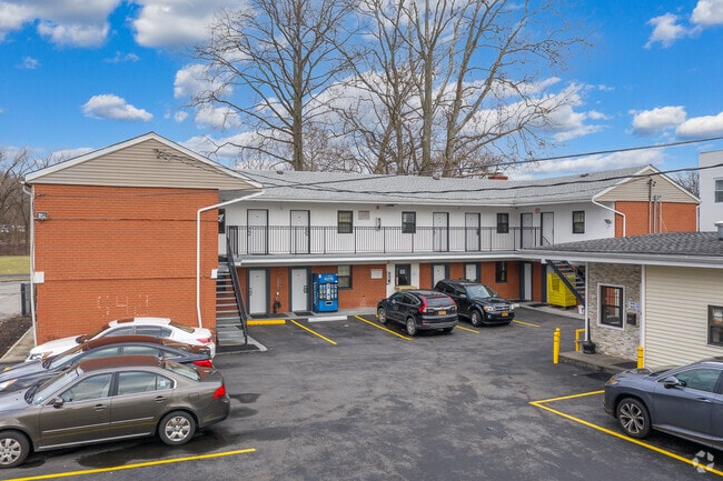
Property Record
542 Tarrytown Rd, White Plains, NY 10607
NEARBY LISTINGS FOR SALE OR LEASE
-
-
View all White Plains listings for sale on LoopNet.com
Property Detail
542 Tarrytown Rd
2689-007-410-00235-000-0001
Westchester
Motel
New York
X
2.000
36119C0266F
0.22 AC
2025
Rockland/Westchester
2024
Westchester/So Connecticut
010903
New York-Jersey City-White Plains, NY-NJ
953 SF
DEMOGRAPHICS near 542 Tarrytown Rd
1 Mile
3 Mile
5 Mile
2024 Total Population
11,931
114,963
217,858
2029 Population
11,669
113,262
214,510
Pop Growth 2024-2029
(2.20%)
(1.48%)
(1.54%)
Average Age
43
42
42
2024 Total Households
4,109
44,949
80,973
HH Growth 2024-2029
(2.19%)
(1.44%)
(1.60%)
Median Household Inc
$132,034
$121,116
$136,759
Avg Household Size
2.70
2.40
2.60
2024 Avg HH Vehicles
2.00
2.00
2.00
Median Home Value
$607,122
$597,745
$707,750
Median Year Built
1965
1961
1958
Nearby Places
- Restaurants
- Banks
- Shops
- Fitness
- Groceries
PUBLIC TRANSPORTATION
COMMUTER RAIL
White Plains Station (Harlem Line - Metro-North Commuter Railroad Company (Metro-North))
DRIVE
WALK
Distance
White Plains Station (Harlem Line - Metro-North Commuter Railroad Company (Metro-North))
5 min
2.5 mi
North White Plains Station (Harlem Line - Metro-North Commuter Railroad Company (Metro-North))
DRIVE
WALK
Distance
North White Plains Station (Harlem Line - Metro-North Commuter Railroad Company (Metro-North))
4 min
2.6 mi
AIRPORT
Westchester County
DRIVE
WALK
Distance
Westchester County
15 min
10.2 mi
LaGuardia
DRIVE
WALK
Distance
LaGuardia
39 min
26.2 mi
John F Kennedy International
DRIVE
WALK
Distance
John F Kennedy International
49 min
32.9 mi
Freight Ports
NY - Red Hook Container Terminal
DRIVE
WALK
Distance
NY - Red Hook Container Terminal
51 min
34.4 mi
Nearby Properties
Address
Land Use
TOTAL SIZE
Lot Size
Zoning
Address
Land Use
TOTAL SIZE
Lot Size
Zoning
358.83 AC
Address
Land Use
TOTAL SIZE
Lot Size
Zoning
85.40 AC
Address
Land Use
TOTAL SIZE
Lot Size
Zoning
4.45 AC
B
Address
Land Use
TOTAL SIZE
Lot Size
Zoning
2,760 SF
60.76 AC
Address
Land Use
TOTAL SIZE
Lot Size
Zoning
63.40 AC
R-40
Address
Land Use
TOTAL SIZE
Lot Size
Zoning
63.48 AC
R-30
Address
Land Use
TOTAL SIZE
Lot Size
Zoning
22.92 AC
Address
Land Use
TOTAL SIZE
Lot Size
Zoning
75.87 AC
R-20
Address
Land Use
TOTAL SIZE
Lot Size
Zoning
Address
Land Use
TOTAL SIZE
Lot Size
Zoning
24.28 AC
Address
Land Use
TOTAL SIZE
Lot Size
Zoning
36.59 AC
Address
Land Use
TOTAL SIZE
Lot Size
Zoning
17.17 AC
Address
Land Use
TOTAL SIZE
Lot Size
Zoning
14.86 AC
OB
Address
Land Use
TOTAL SIZE
Lot Size
Zoning
24.66 AC
Address
Land Use
TOTAL SIZE
Lot Size
Zoning
16.22 AC
UR
Address
Land Use
TOTAL SIZE
Lot Size
Zoning
19.25 AC
Address
Land Use
TOTAL SIZE
Lot Size
Zoning
28.51 AC
Address
Land Use
TOTAL SIZE
Lot Size
Zoning
253,167 SF
9.11 AC
OB
Address
Land Use
TOTAL SIZE
Lot Size
Zoning
60.01 AC
Address
Land Use
TOTAL SIZE
Lot Size
Zoning
8.42 AC
Address
Land Use
TOTAL SIZE
Lot Size
Zoning
Address
Land Use
TOTAL SIZE
Lot Size
Zoning
22.44 AC
R-20
Address
Land Use
TOTAL SIZE
Lot Size
Zoning
26.50 AC
Address
Land Use
TOTAL SIZE
Lot Size
Zoning
11.61 AC
Address
Land Use
TOTAL SIZE
Lot Size
Zoning
Address
Land Use
TOTAL SIZE
Lot Size
Zoning
57.73 AC
Address
Land Use
TOTAL SIZE
Lot Size
Zoning
7.98 AC
CA
Address
Land Use
TOTAL SIZE
Lot Size
Zoning
1,975 SF
13.80 AC
CA
Address
Land Use
TOTAL SIZE
Lot Size
Zoning
22.50 AC
Address
Land Use
TOTAL SIZE
Lot Size
Zoning
68,000 SF
1.53 AC
B
The World's #1 Commercial Real Estate Marketplace
Connect with us
© 2025 CoStar Group
The information above has been obtained from sources believed reliable. While we do not doubt its accuracy we have not verified it and make no guarantee, warranty or representation about it. It is your responsibility to independently confirm its accuracy and completeness. Any projections, opinions, assumptions, or estimates used are for example only and do not represent the current or future performance of the property. The value of this transaction to you depends on tax and other factors which should be evaluated by your tax, financial, and legal advisors. You and your advisors should conduct a careful, independent investigation of the property to determine to your satisfaction the suitability of the property for your needs.