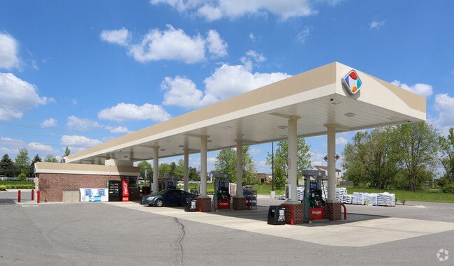
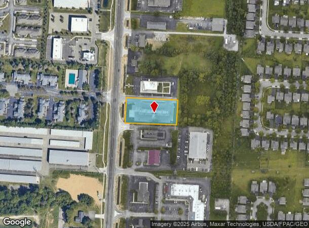
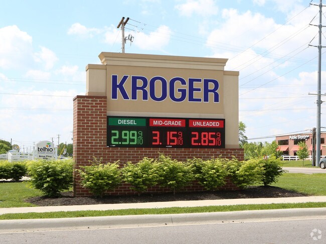
Property Record
5420 N Hamilton Rd, Columbus, OH 43230
NEARBY LISTINGS FOR SALE OR LEASE
Property Detail
5420 N Hamilton Rd
Columbus, OH
U S Military Lands
010-295573
WM BEECHAM RD R16 T2 1/4T3 1.016 ACRES
Servicestation
Franklin
2024
Ohio
2024
1.02 AC
007209
Westerville
270 SF
Columbus
DEMOGRAPHICS near 5420 N Hamilton Rd
1 Mile
3 Mile
5 Mile
2024 Total Population
14,337
79,397
180,174
2029 Population
14,305
79,456
180,281
Pop Growth 2024-2029
(0.22%)
+ 0.07%
+ 0.06%
Average Age
38
39
38
2024 Total Households
6,689
34,174
72,982
HH Growth 2024-2029
(0.42%)
0.00%
+ 0.01%
Median Household Inc
$83,090
$91,930
$82,953
Avg Household Size
2.10
2.30
2.40
2024 Avg HH Vehicles
2.00
2.00
2.00
Median Home Value
$266,401
$289,699
$275,164
Median Year Built
2003
1996
1990
Nearby Places
Map Layers
Map Styles
 Street
 Aerial
- Restaurants
- Banks
- Shops
- Fitness
- Groceries
PUBLIC TRANSPORTATION
AIRPORT
John Glenn Columbus International
DRIVE
WALK
Distance
John Glenn Columbus International
14 min
7.5 mi
Rickenbacker International
DRIVE
WALK
Distance
Rickenbacker International
30 min
20.4 mi
Freight Ports
Port of Toledo
DRIVE
WALK
Distance
Port of Toledo
183 min
144.6 mi
SALE & LEASE HISTORY
LISTING DATE
SALE/LEASE

May 30, 2018
For Sale
Apr 12, 2018
For Lease
Nearby Properties
Address
Land Use
TOTAL SIZE
Lot Size
Zoning
Address
Land Use
TOTAL SIZE
Lot Size
Zoning
696,736 SF
76.73 AC
Address
Land Use
TOTAL SIZE
Lot Size
Zoning
1,935,173 SF
202.04 AC
Address
Land Use
TOTAL SIZE
Lot Size
Zoning
529,035 SF
37.56 AC
Address
Land Use
TOTAL SIZE
Lot Size
Zoning
449,494 SF
9.75 AC
Address
Land Use
TOTAL SIZE
Lot Size
Zoning
570,003 SF
29.71 AC
Address
Land Use
TOTAL SIZE
Lot Size
Zoning
253,127 SF
31.59 AC
Address
Land Use
TOTAL SIZE
Lot Size
Zoning
186,557 SF
35.69 AC
Address
Land Use
TOTAL SIZE
Lot Size
Zoning
316,548 SF
145.20 AC
Address
Land Use
TOTAL SIZE
Lot Size
Zoning
25,298 SF
33.25 AC
Address
Land Use
TOTAL SIZE
Lot Size
Zoning
112,126 SF
19.09 AC
Address
Land Use
TOTAL SIZE
Lot Size
Zoning
67,754 SF
37.90 AC
Address
Land Use
TOTAL SIZE
Lot Size
Zoning
260,944 SF
17.30 AC
Address
Land Use
TOTAL SIZE
Lot Size
Zoning
602,448 SF
24.71 AC
Address
Land Use
TOTAL SIZE
Lot Size
Zoning
537,537 SF
77.62 AC
Address
Land Use
TOTAL SIZE
Lot Size
Zoning
45,135 SF
22.02 AC
Address
Land Use
TOTAL SIZE
Lot Size
Zoning
47,003 SF
24.68 AC
Address
Land Use
TOTAL SIZE
Lot Size
Zoning
299,890 SF
74.80 AC
Address
Land Use
TOTAL SIZE
Lot Size
Zoning
62,660 SF
41.24 AC
Address
Land Use
TOTAL SIZE
Lot Size
Zoning
80,007 SF
27.54 AC
Address
Land Use
TOTAL SIZE
Lot Size
Zoning
180,968 SF
12.77 AC
Address
Land Use
TOTAL SIZE
Lot Size
Zoning
331,458 SF
15.37 AC
Address
Land Use
TOTAL SIZE
Lot Size
Zoning
204,829 SF
37.69 AC
Address
Land Use
TOTAL SIZE
Lot Size
Zoning
94,416 SF
13.95 AC
Address
Land Use
TOTAL SIZE
Lot Size
Zoning
71,592 SF
32.42 AC
Address
Land Use
TOTAL SIZE
Lot Size
Zoning
74,620 SF
9.03 AC
Address
Land Use
TOTAL SIZE
Lot Size
Zoning
150,718 SF
4.35 AC
Address
Land Use
TOTAL SIZE
Lot Size
Zoning
144,900 SF
11.04 AC
Address
Land Use
TOTAL SIZE
Lot Size
Zoning
500,376 SF
3 AC
Address
Land Use
TOTAL SIZE
Lot Size
Zoning
151,892 SF
8.63 AC
Address
Land Use
TOTAL SIZE
Lot Size
Zoning
151,935 SF
9 AC
The World's #1 Commercial Real Estate Marketplace
Connect with us
© 2025 CoStar Group
The information above has been obtained from sources believed reliable. While we do not doubt its accuracy we have not verified it and make no guarantee, warranty or representation about it. It is your responsibility to independently confirm its accuracy and completeness. Any projections, opinions, assumptions, or estimates used are for example only and do not represent the current or future performance of the property. The value of this transaction to you depends on tax and other factors which should be evaluated by your tax, financial, and legal advisors. You and your advisors should conduct a careful, independent investigation of the property to determine to your satisfaction the suitability of the property for your needs.