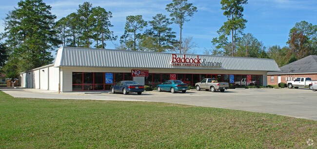
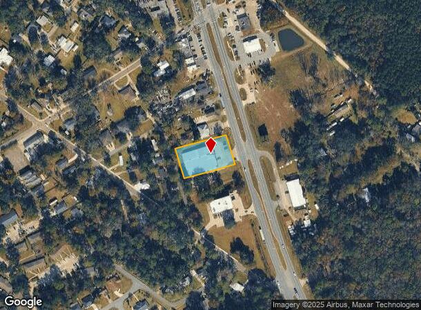
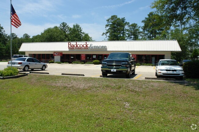
Property Record
542057 Us Highway 1, Callahan, FL 32011
NEARBY LISTINGS FOR SALE OR LEASE
Property Detail
542057 Us Highway 1
Jacksonville, FL
Piney Point Sub
49-2N-25-4120-0015-0000
LOTS 15 THRU 18 ESMT PT OR 489/580 & 581 ESMTS OR 492/420 & OR 608/664 PINEY POINT SUB PB 3/62
Storemultistory
Nassau
X
Florida
12031C0025H
15
2025
0.89 AC
2025
Nassau County
050509
Jacksonville (Florida)
14,732 SF
DEMOGRAPHICS near 542057 Us Highway 1
1 Mile
3 Mile
5 Mile
2024 Total Population
2,147
7,903
13,366
2029 Population
2,580
9,412
15,877
Pop Growth 2024-2029
+ 20.17%
+ 19.09%
+ 18.79%
Average Age
38
40
41
2024 Total Households
804
2,903
4,901
HH Growth 2024-2029
+ 21.39%
+ 20.22%
+ 19.93%
Median Household Inc
$66,992
$68,655
$67,453
Avg Household Size
2.70
2.70
2.70
2024 Avg HH Vehicles
2.00
2.00
2.00
Median Home Value
$217,786
$240,425
$240,733
Median Year Built
1998
2000
1998
Nearby Places
Map Layers
Map Styles
 Street
 Aerial
- Restaurants
- Banks
- Shops
- Fitness
- Groceries
PUBLIC TRANSPORTATION
AIRPORT
Jacksonville International
DRIVE
WALK
Distance
Jacksonville International
25 min
14.3 mi
Nearby Properties
Address
Land Use
TOTAL SIZE
Lot Size
Zoning
Address
Land Use
TOTAL SIZE
Lot Size
Zoning
126,202 SF
27.05 AC
PBLC
Address
Land Use
TOTAL SIZE
Lot Size
Zoning
80,904 SF
13.30 AC
PBLC
Address
Land Use
TOTAL SIZE
Lot Size
Zoning
91,506 SF
16.98 AC
RM
Address
Land Use
TOTAL SIZE
Lot Size
Zoning
85,379 SF
4.70 AC
CG - CALLA
Address
Land Use
TOTAL SIZE
Lot Size
Zoning
89,323 SF
9.04 AC
RM - CALLA
Address
Land Use
TOTAL SIZE
Lot Size
Zoning
56,808 SF
9.46 AC
CH
Address
Land Use
TOTAL SIZE
Lot Size
Zoning
79,777 SF
9.83 AC
CH
Address
Land Use
TOTAL SIZE
Lot Size
Zoning
94,897 SF
9.43 AC
CH
Address
Land Use
TOTAL SIZE
Lot Size
Zoning
21,971 SF
3.60 AC
INTNS
Address
Land Use
TOTAL SIZE
Lot Size
Zoning
8,480 SF
6.27 AC
PBLC
Address
Land Use
TOTAL SIZE
Lot Size
Zoning
26,771 SF
2.35 AC
CH
Address
Land Use
TOTAL SIZE
Lot Size
Zoning
20,242 SF
13 AC
OR
Address
Land Use
TOTAL SIZE
Lot Size
Zoning
32,624 SF
3.98 AC
CH
Address
Land Use
TOTAL SIZE
Lot Size
Zoning
42,649 SF
1.28 AC
CI
Address
Land Use
TOTAL SIZE
Lot Size
Zoning
17,316 SF
22.50 AC
OR
Address
Land Use
TOTAL SIZE
Lot Size
Zoning
17.45 AC
INTNS
Address
Land Use
TOTAL SIZE
Lot Size
Zoning
28,404 SF
31.17 AC
OR
Address
Land Use
TOTAL SIZE
Lot Size
Zoning
17,251 SF
0.45 AC
CH
Address
Land Use
TOTAL SIZE
Lot Size
Zoning
50,945 SF
151.46 AC
GPU
Address
Land Use
TOTAL SIZE
Lot Size
Zoning
12,091 SF
0.55 AC
CH
Address
Land Use
TOTAL SIZE
Lot Size
Zoning
12,364 SF
1.10 AC
PBLC
Address
Land Use
TOTAL SIZE
Lot Size
Zoning
6,792 SF
4.18 AC
INTNS
Address
Land Use
TOTAL SIZE
Lot Size
Zoning
17,748 SF
2.19 AC
CH
Address
Land Use
TOTAL SIZE
Lot Size
Zoning
3,375 SF
1.15 AC
CH
Address
Land Use
TOTAL SIZE
Lot Size
Zoning
4,617 SF
0.43 AC
CH
Address
Land Use
TOTAL SIZE
Lot Size
Zoning
13,930 SF
2.66 AC
CH
Address
Land Use
TOTAL SIZE
Lot Size
Zoning
3,819 SF
1.46 AC
CH
Address
Land Use
TOTAL SIZE
Lot Size
Zoning
11,796 SF
0.48 AC
RM
Address
Land Use
TOTAL SIZE
Lot Size
Zoning
15,098 SF
1.78 AC
CH
Address
Land Use
TOTAL SIZE
Lot Size
Zoning
7,047 SF
0.64 AC
CG - CALLA
The World's #1 Commercial Real Estate Marketplace
Connect with us
© 2026 CoStar Group
The information above has been obtained from sources believed reliable. While we do not doubt its accuracy we have not verified it and make no guarantee, warranty or representation about it. It is your responsibility to independently confirm its accuracy and completeness. Any projections, opinions, assumptions, or estimates used are for example only and do not represent the current or future performance of the property. The value of this transaction to you depends on tax and other factors which should be evaluated by your tax, financial, and legal advisors. You and your advisors should conduct a careful, independent investigation of the property to determine to your satisfaction the suitability of the property for your needs.