Property Record
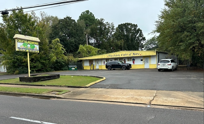
5421 Knight Arnold Rd, Memphis, TN 38115


This Property Is For Sale
NEARBY LISTINGS FOR SALE OR LEASE
Property Detail
5421 Knight Arnold Rd
Memphis, TN-MS-AR
Fox Meadows Sec H1
07-4073-E0-0004
MAP 179 I
Daycare
Shelby
X
Tennessee
47157C0445F
6
2024
0.48 AC
2025
Southeast
010820
Memphis
3,000 SF
DEMOGRAPHICS near 5421 Knight Arnold Rd
1 Mile
3 Mile
5 Mile
2024 Total Population
15,198
99,011
193,066
2029 Population
14,753
97,399
189,210
Pop Growth 2024-2029
(2.93%)
(1.63%)
(2.00%)
Average Age
35
35
37
2024 Total Households
5,394
38,109
76,043
HH Growth 2024-2029
(3.04%)
(1.64%)
(2.08%)
Median Household Inc
$48,292
$52,882
$63,229
Avg Household Size
2.70
2.50
2.50
2024 Avg HH Vehicles
2.00
2.00
2.00
Median Home Value
$170,099
$188,599
$240,610
Median Year Built
1970
1974
1975
Nearby Places
Map Layers
Map Styles
 Street
 Aerial
- Restaurants
- Banks
- Shops
- Fitness
- Groceries
PUBLIC TRANSPORTATION
AIRPORT
Memphis International
DRIVE
WALK
Distance
Memphis International
17 min
7.2 mi
Nearby Properties
Address
Land Use
TOTAL SIZE
Lot Size
Zoning
Address
Land Use
TOTAL SIZE
Lot Size
Zoning
1,082,619 SF
34.67 AC
CMP-1
Address
Land Use
TOTAL SIZE
Lot Size
Zoning
451,249 SF
24.28 AC
RU-2
Address
Land Use
TOTAL SIZE
Lot Size
Zoning
704,564 SF
28.30 AC
EMP
Address
Land Use
TOTAL SIZE
Lot Size
Zoning
1,403,383 SF
93.69 AC
IH
Address
Land Use
TOTAL SIZE
Lot Size
Zoning
189,536 SF
49.14 AC
CMU-2
Address
Land Use
TOTAL SIZE
Lot Size
Zoning
237,911 SF
21.38 AC
EMP
Address
Land Use
TOTAL SIZE
Lot Size
Zoning
498,764 SF
22.57 AC
CA
Address
Land Use
TOTAL SIZE
Lot Size
Zoning
1,292,907 SF
83.13 AC
IH
Address
Land Use
TOTAL SIZE
Lot Size
Zoning
419,065 SF
19.92 AC
EMP
Address
Land Use
TOTAL SIZE
Lot Size
Zoning
16,432 SF
445 AC
EMP
Address
Land Use
TOTAL SIZE
Lot Size
Zoning
2,505 SF
52.59 AC
R-10
Address
Land Use
TOTAL SIZE
Lot Size
Zoning
262,984 SF
8.09 AC
R-TH
Address
Land Use
TOTAL SIZE
Lot Size
Zoning
38,488 SF
5.68 AC
CMU-1
Address
Land Use
TOTAL SIZE
Lot Size
Zoning
269,022 SF
23.76 AC
RU-3
Address
Land Use
TOTAL SIZE
Lot Size
Zoning
51,600 SF
24.06 AC
RU-3
Address
Land Use
TOTAL SIZE
Lot Size
Zoning
188,458 SF
29.19 AC
RU-3
Address
Land Use
TOTAL SIZE
Lot Size
Zoning
66,067 SF
3.01 AC
CMU-3
Address
Land Use
TOTAL SIZE
Lot Size
Zoning
145,980 SF
16.50 AC
RU-3
Address
Land Use
TOTAL SIZE
Lot Size
Zoning
48,768 SF
7.51 AC
R-8
Address
Land Use
TOTAL SIZE
Lot Size
Zoning
113,826 SF
29.01 AC
RU-3
Address
Land Use
TOTAL SIZE
Lot Size
Zoning
96,768 SF
7.98 AC
OG
Address
Land Use
TOTAL SIZE
Lot Size
Zoning
618,133 SF
37.58 AC
EMP
Address
Land Use
TOTAL SIZE
Lot Size
Zoning
176,176 SF
26.62 AC
R-8
Address
Land Use
TOTAL SIZE
Lot Size
Zoning
259,286 SF
12.76 AC
RU-3
Address
Land Use
TOTAL SIZE
Lot Size
Zoning
592,766 SF
26.76 AC
EMP
Address
Land Use
TOTAL SIZE
Lot Size
Zoning
28.04 AC
R-10
Address
Land Use
TOTAL SIZE
Lot Size
Zoning
500,000 SF
22.75 AC
EMP
Address
Land Use
TOTAL SIZE
Lot Size
Zoning
224,407 SF
23.22 AC
R-8
Address
Land Use
TOTAL SIZE
Lot Size
Zoning
363,473 SF
16.53 AC
IH
Address
Land Use
TOTAL SIZE
Lot Size
Zoning
173,579 SF
9.33 AC
EMP
The World's #1 Commercial Real Estate Marketplace
Connect with us
© 2026 CoStar Group
The information above has been obtained from sources believed reliable. While we do not doubt its accuracy we have not verified it and make no guarantee, warranty or representation about it. It is your responsibility to independently confirm its accuracy and completeness. Any projections, opinions, assumptions, or estimates used are for example only and do not represent the current or future performance of the property. The value of this transaction to you depends on tax and other factors which should be evaluated by your tax, financial, and legal advisors. You and your advisors should conduct a careful, independent investigation of the property to determine to your satisfaction the suitability of the property for your needs.