Property Record
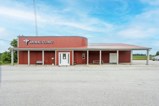
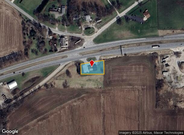
5424 E Us Highway 20, Rolling Prairie, IN 46371
This Property Is For Sale
NEARBY LISTINGS FOR SALE OR LEASE
-
-
View all Rolling Prairie listings for sale on LoopNet.com
Property Detail
5424 E Us Highway 20
46-07-12-300-004.000-068
Mid Pt N Sd
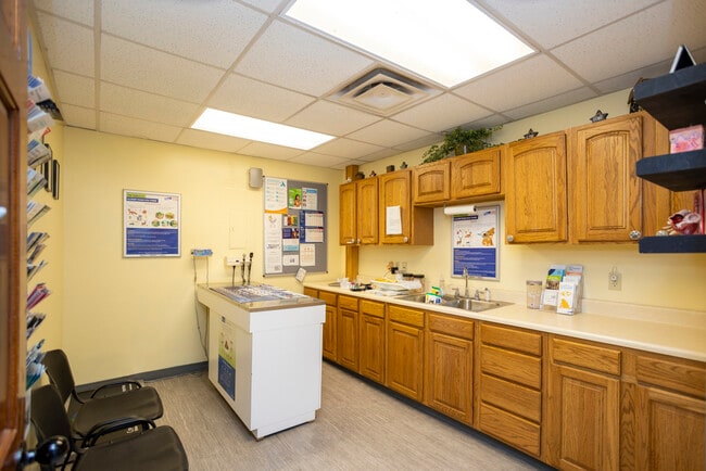
Medicalbuilding
78-07-12-300-004 MID PT N SD SW 1/4 S OF RR S12 T37 R2 .50 AC
X
La Porte
18091C0190D
Indiana
2023
0.50 AC
2024
South Bend/Elkhart
041800
Other Market Areas
2,244 SF
Michigan City-La Porte, IN
DEMOGRAPHICS near 5424 E Us Highway 20
1 Mile
3 Mile
5 Mile
2024 Total Population
709
2,855
9,466
2029 Population
690
2,795
9,341
Pop Growth 2024-2029
(2.68%)
(2.10%)
(1.32%)
Average Age
42
42
42
2024 Total Households
260
1,040
3,595
HH Growth 2024-2029
(3.08%)
(2.31%)
(1.39%)
Median Household Inc
$88,095
$86,556
$86,025
Avg Household Size
2.60
2.60
2.60
2024 Avg HH Vehicles
3.00
3.00
2.00
Median Home Value
$250,000
$256,388
$248,956
Median Year Built
1972
1974
1978
Nearby Places
- Restaurants
- Banks
- Shops
- Fitness
- Groceries
PUBLIC TRANSPORTATION
COMMUTER RAIL
Hudson Lake (Laporte County) Station (South Shore Line - Northern Indiana Commuter Transportation District (South Shore Line))
DRIVE
WALK
Distance
Hudson Lake (Laporte County) Station (South Shore Line - Northern Indiana Commuter Transportation District (South Shore Line))
8 min
4.3 mi
AIRPORT
South Bend International
DRIVE
WALK
Distance
South Bend International
32 min
17.8 mi
Freight Ports
Port Milwaukee
DRIVE
WALK
Distance
Port Milwaukee
196 min
158.5 mi
Nearby Properties
Address
Land Use
TOTAL SIZE
Lot Size
Zoning
Address
Land Use
TOTAL SIZE
Lot Size
Zoning
103,488 SF
51.58 AC
Address
Land Use
TOTAL SIZE
Lot Size
Zoning
20,289 SF
43.09 AC
Address
Land Use
TOTAL SIZE
Lot Size
Zoning
196,500 SF
13.58 AC
Address
Land Use
TOTAL SIZE
Lot Size
Zoning
9,425 SF
1.71 AC
Address
Land Use
TOTAL SIZE
Lot Size
Zoning
2,912 SF
33.17 AC
Address
Land Use
TOTAL SIZE
Lot Size
Zoning
13,770 SF
75.95 AC
Address
Land Use
TOTAL SIZE
Lot Size
Zoning
31,103 SF
9.60 AC
Address
Land Use
TOTAL SIZE
Lot Size
Zoning
15,552 SF
1 AC
Address
Land Use
TOTAL SIZE
Lot Size
Zoning
35,570 SF
10 AC
Address
Land Use
TOTAL SIZE
Lot Size
Zoning
18,267 SF
39.89 AC
Address
Land Use
TOTAL SIZE
Lot Size
Zoning
8,294 SF
106.88 AC
Address
Land Use
TOTAL SIZE
Lot Size
Zoning
75.37 AC
Address
Land Use
TOTAL SIZE
Lot Size
Zoning
3,813 SF
160 AC
Address
Land Use
TOTAL SIZE
Lot Size
Zoning
6,553 SF
79.59 AC
Address
Land Use
TOTAL SIZE
Lot Size
Zoning
9,255 SF
16.68 AC
Address
Land Use
TOTAL SIZE
Lot Size
Zoning
331.14 AC
Address
Land Use
TOTAL SIZE
Lot Size
Zoning
5,476 SF
120.64 AC
Address
Land Use
TOTAL SIZE
Lot Size
Zoning
5,834 SF
77.94 AC
Address
Land Use
TOTAL SIZE
Lot Size
Zoning
8,932 SF
30 AC
Address
Land Use
TOTAL SIZE
Lot Size
Zoning
2,963 SF
100 AC
Address
Land Use
TOTAL SIZE
Lot Size
Zoning
6,794 SF
8.79 AC
Address
Land Use
TOTAL SIZE
Lot Size
Zoning
3,788 SF
82.39 AC
Address
Land Use
TOTAL SIZE
Lot Size
Zoning
6,650 SF
6.71 AC
Address
Land Use
TOTAL SIZE
Lot Size
Zoning
6,879 SF
16.02 AC
Address
Land Use
TOTAL SIZE
Lot Size
Zoning
5,495 SF
9.09 AC
Address
Land Use
TOTAL SIZE
Lot Size
Zoning
30,500 SF
2.68 AC
Address
Land Use
TOTAL SIZE
Lot Size
Zoning
3,168 SF
116.61 AC
Address
Land Use
TOTAL SIZE
Lot Size
Zoning
6,182 SF
19.44 AC
Address
Land Use
TOTAL SIZE
Lot Size
Zoning
5,884 SF
15.59 AC
Address
Land Use
TOTAL SIZE
Lot Size
Zoning
4,902 SF
20.30 AC
The World's #1 Commercial Real Estate Marketplace
Connect with us
© 2025 CoStar Group
The information above has been obtained from sources believed reliable. While we do not doubt its accuracy we have not verified it and make no guarantee, warranty or representation about it. It is your responsibility to independently confirm its accuracy and completeness. Any projections, opinions, assumptions, or estimates used are for example only and do not represent the current or future performance of the property. The value of this transaction to you depends on tax and other factors which should be evaluated by your tax, financial, and legal advisors. You and your advisors should conduct a careful, independent investigation of the property to determine to your satisfaction the suitability of the property for your needs.