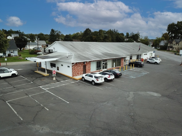
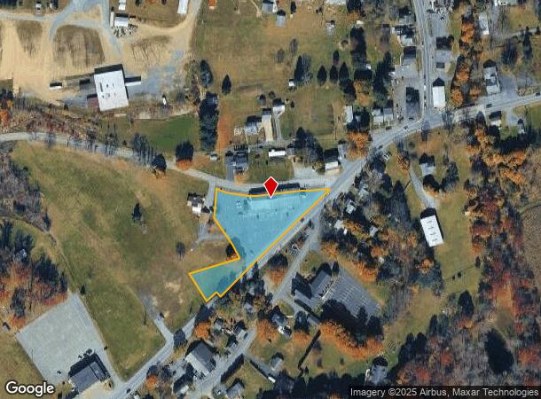
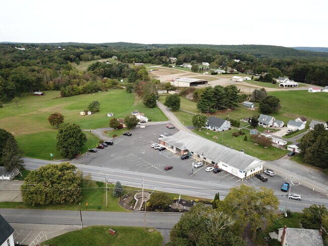
Property Record
543 Interchange Rd, Kresgeville, PA 18333
NEARBY LISTINGS FOR SALE OR LEASE
-
-
View all Kresgeville listings for sale on LoopNet.com
Property Detail
543 Interchange Rd
East Stroudsburg, PA
Richard Strausberger
13.6.1.60
LOT 1
Financialbuilding
Monroe
X
Pennsylvania
42089C0390E
1
2025
1.92 AC
2025
Monroe County
301303
Philadelphia
9,104 SF
DEMOGRAPHICS near 543 Interchange Rd
1 Mile
3 Mile
5 Mile
2024 Total Population
647
5,381
15,218
2029 Population
626
5,292
15,228
Pop Growth 2024-2029
(3.25%)
(1.65%)
+ 0.07%
Average Age
44
44
44
2024 Total Households
253
2,084
5,793
HH Growth 2024-2029
(3.16%)
(1.63%)
+ 0.09%
Median Household Inc
$98,683
$83,498
$84,340
Avg Household Size
2.60
2.50
2.60
2024 Avg HH Vehicles
3.00
3.00
2.00
Median Home Value
$284,027
$243,740
$227,619
Median Year Built
1973
1980
1982
Nearby Places
Map Layers
Map Styles
 Street
 Aerial
- Restaurants
- Banks
- Shops
- Fitness
- Groceries
PUBLIC TRANSPORTATION
AIRPORT
Lehigh Valley International
DRIVE
WALK
Distance
Lehigh Valley International
47 min
39.9 mi
Freight Ports
Port of Philadelphia
DRIVE
WALK
Distance
Port of Philadelphia
1 min
67.1 mi
SALE & LEASE HISTORY
LISTING DATE
SALE/LEASE

Dec 27, 2022
For Sale
Nearby Properties
Address
Land Use
TOTAL SIZE
Lot Size
Zoning
Address
Land Use
TOTAL SIZE
Lot Size
Zoning
157,852 SF
145.94 AC
R-2
Address
Land Use
TOTAL SIZE
Lot Size
Zoning
145,840 SF
91.67 AC
R-2
Address
Land Use
TOTAL SIZE
Lot Size
Zoning
20,324 SF
32.20 AC
C
Address
Land Use
TOTAL SIZE
Lot Size
Zoning
9,100 SF
2.82 AC
C
Address
Land Use
TOTAL SIZE
Lot Size
Zoning
4,118 SF
2.01 AC
R-3
Address
Land Use
TOTAL SIZE
Lot Size
Zoning
7,168 SF
1.16 AC
R-1
Address
Land Use
TOTAL SIZE
Lot Size
Zoning
9,974 SF
1.70 AC
R-3
Address
Land Use
TOTAL SIZE
Lot Size
Zoning
15,479 SF
10.39 AC
C
Address
Land Use
TOTAL SIZE
Lot Size
Zoning
2,264 SF
10.15 AC
R-3
Address
Land Use
TOTAL SIZE
Lot Size
Zoning
9,816 SF
1 AC
R1
Address
Land Use
TOTAL SIZE
Lot Size
Zoning
7,171 SF
1.65 AC
RR
Address
Land Use
TOTAL SIZE
Lot Size
Zoning
11,610 SF
2.23 AC
I
Address
Land Use
TOTAL SIZE
Lot Size
Zoning
5,358 SF
4.09 AC
R-3
Address
Land Use
TOTAL SIZE
Lot Size
Zoning
6,030 SF
2.40 AC
C
Address
Land Use
TOTAL SIZE
Lot Size
Zoning
3,260 SF
39.73 AC
C
Address
Land Use
TOTAL SIZE
Lot Size
Zoning
9.06 AC
Address
Land Use
TOTAL SIZE
Lot Size
Zoning
8,920 SF
7.78 AC
R-3
Address
Land Use
TOTAL SIZE
Lot Size
Zoning
95.07 AC
R-1
Address
Land Use
TOTAL SIZE
Lot Size
Zoning
7,000 SF
6.32 AC
R-3
Address
Land Use
TOTAL SIZE
Lot Size
Zoning
2,801 SF
115.80 AC
AR
Address
Land Use
TOTAL SIZE
Lot Size
Zoning
4,620 SF
3.78 AC
C
Address
Land Use
TOTAL SIZE
Lot Size
Zoning
6,664 SF
2.16 AC
I
Address
Land Use
TOTAL SIZE
Lot Size
Zoning
2,816 SF
1.68 AC
I
Address
Land Use
TOTAL SIZE
Lot Size
Zoning
3,008 SF
0.55 AC
C
Address
Land Use
TOTAL SIZE
Lot Size
Zoning
1,732 SF
2.69 AC
Address
Land Use
TOTAL SIZE
Lot Size
Zoning
4,368 SF
1.50 AC
R
Address
Land Use
TOTAL SIZE
Lot Size
Zoning
2,912 SF
1.50 AC
Address
Land Use
TOTAL SIZE
Lot Size
Zoning
237.03 AC
I
Address
Land Use
TOTAL SIZE
Lot Size
Zoning
5,304 SF
15.54 AC
R-3
The World's #1 Commercial Real Estate Marketplace
Connect with us
© 2025 CoStar Group
The information above has been obtained from sources believed reliable. While we do not doubt its accuracy we have not verified it and make no guarantee, warranty or representation about it. It is your responsibility to independently confirm its accuracy and completeness. Any projections, opinions, assumptions, or estimates used are for example only and do not represent the current or future performance of the property. The value of this transaction to you depends on tax and other factors which should be evaluated by your tax, financial, and legal advisors. You and your advisors should conduct a careful, independent investigation of the property to determine to your satisfaction the suitability of the property for your needs.