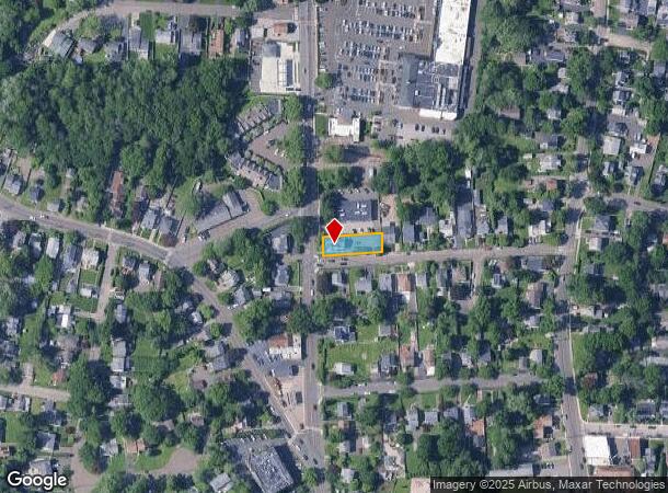
Property Record
543 Newfield Ave, Stamford, CT 06905
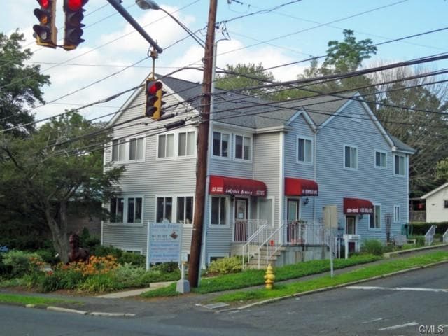
This Property Is For Sale
NEARBY LISTINGS FOR SALE OR LEASE
Property Detail
543 Newfield Ave
Commercialbuilding
Fairfield
X
Connecticut
09001C0508F
0.19 AC
2025
Stamford
2025
Westchester/So Connecticut
021000
Bridgeport-Stamford-Norwalk, CT
2,939 SF
STAM-000001-000000-000056
DEMOGRAPHICS near 543 Newfield Ave
1 Mile
3 Mile
5 Mile
2024 Total Population
17,376
141,010
199,972
2029 Population
17,408
142,019
201,245
Pop Growth 2024-2029
+ 0.18%
+ 0.72%
+ 0.64%
Average Age
40
39
39
2024 Total Households
6,636
55,358
75,456
HH Growth 2024-2029
+ 0.14%
+ 0.98%
+ 0.81%
Median Household Inc
$123,052
$102,835
$120,160
Avg Household Size
2.50
2.40
2.50
2024 Avg HH Vehicles
2.00
2.00
2.00
Median Home Value
$571,115
$630,996
$806,009
Median Year Built
1959
1972
1969
Nearby Places
- Restaurants
- Banks
- Shops
- Fitness
- Groceries
PUBLIC TRANSPORTATION
COMMUTER RAIL
Springdale Mw Facility (New Canaan - Metro-North Railroad)
DRIVE
WALK
Distance
Springdale Mw Facility (New Canaan - Metro-North Railroad)
4 min
1.2 mi
Glenbrook Station (New Haven Line - Metro-North Commuter Railroad Company (Metro-North))
DRIVE
WALK
Distance
Glenbrook Station (New Haven Line - Metro-North Commuter Railroad Company (Metro-North))
3 min
1.4 mi
AIRPORT
Westchester County
DRIVE
WALK
Distance
Westchester County
27 min
15.0 mi
LaGuardia
DRIVE
WALK
Distance
LaGuardia
53 min
34.3 mi
Freight Ports
Port of New Haven
DRIVE
WALK
Distance
Port of New Haven
61 min
41.8 mi
Nearby Properties
Address
Land Use
TOTAL SIZE
Lot Size
Zoning
Address
Land Use
TOTAL SIZE
Lot Size
Zoning
13.21 AC
CSCD
Address
Land Use
TOTAL SIZE
Lot Size
Zoning
8.91 AC
DC
Address
Land Use
TOTAL SIZE
Lot Size
Zoning
336,000 SF
40 AC
MU
Address
Land Use
TOTAL SIZE
Lot Size
Zoning
5.10 AC
MXD
Address
Land Use
TOTAL SIZE
Lot Size
Zoning
Address
Land Use
TOTAL SIZE
Lot Size
Zoning
397,378 SF
4.25 AC
CC
Address
Land Use
TOTAL SIZE
Lot Size
Zoning
344,483 SF
CC
Address
Land Use
TOTAL SIZE
Lot Size
Zoning
543,005 SF
2.23 AC
RHD
Address
Land Use
TOTAL SIZE
Lot Size
Zoning
411,596 SF
3.30 AC
MZN
Address
Land Use
TOTAL SIZE
Lot Size
Zoning
4.13 AC
CC
Address
Land Use
TOTAL SIZE
Lot Size
Zoning
358,662 SF
CC
Address
Land Use
TOTAL SIZE
Lot Size
Zoning
46,302 SF
23.50 AC
MG
Address
Land Use
TOTAL SIZE
Lot Size
Zoning
9.62 AC
MZN
Address
Land Use
TOTAL SIZE
Lot Size
Zoning
359,686 SF
1.67 AC
CCN
Address
Land Use
TOTAL SIZE
Lot Size
Zoning
377,754 SF
2.06 AC
PD
Address
Land Use
TOTAL SIZE
Lot Size
Zoning
79.29 AC
P
Address
Land Use
TOTAL SIZE
Lot Size
Zoning
32.68 AC
MD
Address
Land Use
TOTAL SIZE
Lot Size
Zoning
8.21 AC
CWD
Address
Land Use
TOTAL SIZE
Lot Size
Zoning
304,617 SF
CI
Address
Land Use
TOTAL SIZE
Lot Size
Zoning
377,918 SF
22.42 AC
MZN
Address
Land Use
TOTAL SIZE
Lot Size
Zoning
304,345 SF
1.15 AC
PD
Address
Land Use
TOTAL SIZE
Lot Size
Zoning
277,740 SF
2.82 AC
TCDD
Address
Land Use
TOTAL SIZE
Lot Size
Zoning
308,621 SF
CI
Address
Land Use
TOTAL SIZE
Lot Size
Zoning
32.06 AC
DMR
Address
Land Use
TOTAL SIZE
Lot Size
Zoning
235,186 SF
1.29 AC
CG
Address
Land Use
TOTAL SIZE
Lot Size
Zoning
3.14 AC
RH
Address
Land Use
TOTAL SIZE
Lot Size
Zoning
1.95 AC
SRDS
Address
Land Use
TOTAL SIZE
Lot Size
Zoning
243,000 SF
3.02 AC
CG
Address
Land Use
TOTAL SIZE
Lot Size
Zoning
334,905 SF
2.52 AC
MXD
Address
Land Use
TOTAL SIZE
Lot Size
Zoning
32.43 AC
RA1
The World's #1 Commercial Real Estate Marketplace
Connect with us
© 2025 CoStar Group
The information above has been obtained from sources believed reliable. While we do not doubt its accuracy we have not verified it and make no guarantee, warranty or representation about it. It is your responsibility to independently confirm its accuracy and completeness. Any projections, opinions, assumptions, or estimates used are for example only and do not represent the current or future performance of the property. The value of this transaction to you depends on tax and other factors which should be evaluated by your tax, financial, and legal advisors. You and your advisors should conduct a careful, independent investigation of the property to determine to your satisfaction the suitability of the property for your needs.