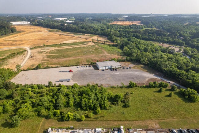
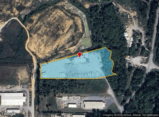
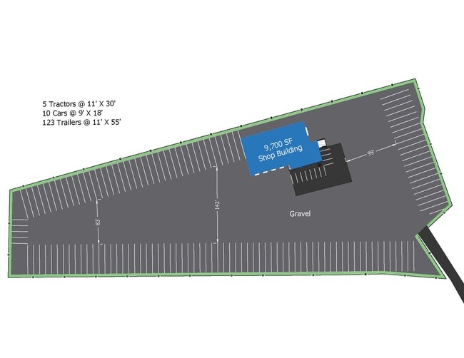
Property Record
543 Old Grassdale Rd Ne, Cartersville, GA 30121

NEARBY LISTINGS FOR SALE OR LEASE
Property Detail
543 Old Grassdale Rd Ne
Atlanta-Sandy Springs-Roswell, GA
Com - Cass White Corridor
0080-0204-006
LL 204 D 5 S3 PLAT BK 35 PG 4
Commercialnec
Bartow
AE
Georgia
13015C0170H
204
2024
6 AC
2024
Kennesaw/Acworth
960407
Atlanta
11,820 SF
DEMOGRAPHICS near 543 Old Grassdale Rd Ne
1 Mile
3 Mile
5 Mile
2024 Total Population
1,133
11,780
39,088
2029 Population
1,251
12,959
42,608
Pop Growth 2024-2029
+ 10.41%
+ 10.01%
+ 9.01%
Average Age
40
38
39
2024 Total Households
434
4,606
14,573
HH Growth 2024-2029
+ 10.14%
+ 9.81%
+ 8.76%
Median Household Inc
$96,918
$72,842
$72,494
Avg Household Size
2.60
2.50
2.60
2024 Avg HH Vehicles
2.00
2.00
2.00
Median Home Value
$251,136
$221,580
$223,904
Median Year Built
2004
1997
1994
Nearby Places
Map Layers
Map Styles
 Street
 Aerial
- Restaurants
- Banks
- Shops
- Fitness
- Groceries
SALE & LEASE HISTORY
LISTING DATE
SALE/LEASE

Jun 20, 2022
For Lease
Jan 04, 2023
For Lease
Nearby Properties
Address
Land Use
TOTAL SIZE
Lot Size
Zoning
Address
Land Use
TOTAL SIZE
Lot Size
Zoning
144,208 SF
585.38 AC
IN
Address
Land Use
TOTAL SIZE
Lot Size
Zoning
791,880 SF
77.99 AC
A1
Address
Land Use
TOTAL SIZE
Lot Size
Zoning
193.36 AC
Address
Land Use
TOTAL SIZE
Lot Size
Zoning
268,772 SF
168.31 AC
Address
Land Use
TOTAL SIZE
Lot Size
Zoning
114.40 AC
Address
Land Use
TOTAL SIZE
Lot Size
Zoning
972,763 SF
68.78 AC
Address
Land Use
TOTAL SIZE
Lot Size
Zoning
107,992 SF
46 AC
IN
Address
Land Use
TOTAL SIZE
Lot Size
Zoning
375.69 AC
IN
Address
Land Use
TOTAL SIZE
Lot Size
Zoning
999,291 SF
73.85 AC
A1
Address
Land Use
TOTAL SIZE
Lot Size
Zoning
823,607 SF
43.60 AC
A1
Address
Land Use
TOTAL SIZE
Lot Size
Zoning
311,878 SF
161.30 AC
Address
Land Use
TOTAL SIZE
Lot Size
Zoning
178,018 SF
48.93 AC
C1
Address
Land Use
TOTAL SIZE
Lot Size
Zoning
646,380 SF
59.66 AC
I1
Address
Land Use
TOTAL SIZE
Lot Size
Zoning
766,373 SF
267.91 AC
I2
Address
Land Use
TOTAL SIZE
Lot Size
Zoning
526,400 SF
64.52 AC
Address
Land Use
TOTAL SIZE
Lot Size
Zoning
523,059 SF
72.54 AC
Address
Land Use
TOTAL SIZE
Lot Size
Zoning
597,183 SF
64.23 AC
Address
Land Use
TOTAL SIZE
Lot Size
Zoning
375,540 SF
31.64 AC
M1
Address
Land Use
TOTAL SIZE
Lot Size
Zoning
396,000 SF
60.87 AC
Address
Land Use
TOTAL SIZE
Lot Size
Zoning
337,336 SF
30.59 AC
A1
Address
Land Use
TOTAL SIZE
Lot Size
Zoning
337,615 SF
34.95 AC
A1
Address
Land Use
TOTAL SIZE
Lot Size
Zoning
328,000 SF
43.09 AC
Address
Land Use
TOTAL SIZE
Lot Size
Zoning
144,416 SF
40.01 AC
A1
Address
Land Use
TOTAL SIZE
Lot Size
Zoning
288,480 SF
40.14 AC
A1
Address
Land Use
TOTAL SIZE
Lot Size
Zoning
311,476 SF
36.54 AC
Address
Land Use
TOTAL SIZE
Lot Size
Zoning
8,760 SF
151.31 AC
IN
Address
Land Use
TOTAL SIZE
Lot Size
Zoning
267,558 SF
28.14 AC
A1
Address
Land Use
TOTAL SIZE
Lot Size
Zoning
155,816 SF
39.86 AC
A1
Address
Land Use
TOTAL SIZE
Lot Size
Zoning
20,000 SF
9.63 AC
C1
Address
Land Use
TOTAL SIZE
Lot Size
Zoning
9,560 SF
12 AC
R3
The World's #1 Commercial Real Estate Marketplace
Connect with us
© 2025 CoStar Group
The information above has been obtained from sources believed reliable. While we do not doubt its accuracy we have not verified it and make no guarantee, warranty or representation about it. It is your responsibility to independently confirm its accuracy and completeness. Any projections, opinions, assumptions, or estimates used are for example only and do not represent the current or future performance of the property. The value of this transaction to you depends on tax and other factors which should be evaluated by your tax, financial, and legal advisors. You and your advisors should conduct a careful, independent investigation of the property to determine to your satisfaction the suitability of the property for your needs.