Property Record
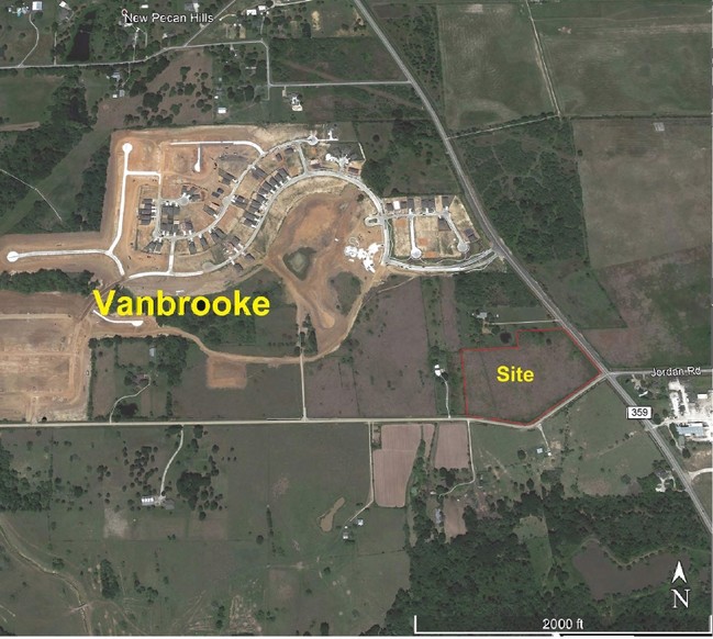
5430 Fm 359 Rd, Richmond, TX 77406

Save to a Folder
{{folder.Name}}
{{folder.ListingIds.length}} Properties
{{folder.ListingIds.length}} Property
Create a New Folder
Property Detail
5430 Fm 359 Rd
Houston-Pasadena-The Woodlands, TX
0014 N BROOKSHIRE, TRACT 32, ACRES 8.86
0014-00-000-0321-901
FORT BEND
Commercialnec
Texas
B and X Area of moderate flood hazard, usually the area between the limits of the 100-year and 500-year floods.
32
2024
9.26 AC
2025
Southwest Outlier
673404
Houston
NEARBY LISTINGS FOR SALE OR LEASE
-
-
-
-
-
-
-
-
-
-
-
-
-
-
-
-
NEC N. Twinwood Parkway @Twinwood Center dr
Brookshire, TX 77423
Rent Upon Request
0.78 - 1.73 AC Lot
Land
-
-
View all Richmond listings for sale on LoopNet.com
DEMOGRAPHICS near 5430 Fm 359 Rd
1 mile
3 mile
5 mile
2025 Total Population
2,840
16,703
76,992
2030 Population
3,455
20,205
89,864
Pop Growth 2025-2030
+ 21.65%
+ 20.97%
+ 16.72%
Average Age
36
37
36
2025 Total Households
929
5,489
23,980
HH Growth 2025-2030
+ 21.96%
+ 21.26%
+ 17.21%
Median Household Inc
$147,634
$148,573
$153,838
Avg Household Size
3.10
3.00
3.20
2025 Avg HH Vehicles
2.00
2.00
2.00
Median Home Value
$559,524
$576,937
$554,182
Median Year Built
2011
2011
2011
Nearby Places
Map Layers
Map Styles
 Street
 Aerial
Layers
 Traffic
 Biking
Places
Listings with unknown addresses are not visible on the map
- Restaurants
- Banks
- Shops
- Fitness
- Groceries
SALE & LEASE HISTORY
LISTING DATE
SALE/LEASE

Aug 12, 2019
For Sale
Nearby Properties
Address
Land Use
TOTAL SIZE
Lot Size
Zoning
Address
Land Use
TOTAL SIZE
Lot Size
Zoning
1,919,248 SF
189.91 AC
Address
Land Use
TOTAL SIZE
Lot Size
Zoning
83.43 AC
Address
Land Use
TOTAL SIZE
Lot Size
Zoning
737,632 SF
34.12 AC
Address
Land Use
TOTAL SIZE
Lot Size
Zoning
734,030 SF
37.13 AC
Address
Land Use
TOTAL SIZE
Lot Size
Zoning
546,000 SF
29.67 AC
Address
Land Use
TOTAL SIZE
Lot Size
Zoning
4.73 AC
Z
Address
Land Use
TOTAL SIZE
Lot Size
Zoning
14.88 AC
Address
Land Use
TOTAL SIZE
Lot Size
Zoning
Address
Land Use
TOTAL SIZE
Lot Size
Zoning
Address
Land Use
TOTAL SIZE
Lot Size
Zoning
12.58 AC
Address
Land Use
TOTAL SIZE
Lot Size
Zoning
58,037 SF
18.96 AC
QXS
Address
Land Use
TOTAL SIZE
Lot Size
Zoning
227,480 SF
14.27 AC
Address
Land Use
TOTAL SIZE
Lot Size
Zoning
137,633 SF
16.40 AC
Address
Land Use
TOTAL SIZE
Lot Size
Zoning
187,888 SF
14.48 AC
Address
Land Use
TOTAL SIZE
Lot Size
Zoning
14.98 AC
Address
Land Use
TOTAL SIZE
Lot Size
Zoning
30.29 AC
Address
Land Use
TOTAL SIZE
Lot Size
Zoning
296.94 AC
YQO
Address
Land Use
TOTAL SIZE
Lot Size
Zoning
254.79 AC
Address
Land Use
TOTAL SIZE
Lot Size
Zoning
70,350 SF
9.34 AC
Address
Land Use
TOTAL SIZE
Lot Size
Zoning
86.07 AC
S
Address
Land Use
TOTAL SIZE
Lot Size
Zoning
74,220 SF
5.55 AC
Address
Land Use
TOTAL SIZE
Lot Size
Zoning
75,336 SF
3.34 AC
Address
Land Use
TOTAL SIZE
Lot Size
Zoning
9.92 AC
QSY
Address
Land Use
TOTAL SIZE
Lot Size
Zoning
14.01 AC
TS
Address
Land Use
TOTAL SIZE
Lot Size
Zoning
Address
Land Use
TOTAL SIZE
Lot Size
Zoning
6.40 AC
Address
Land Use
TOTAL SIZE
Lot Size
Zoning
1,105 SF
196.73 AC
QTYS
Address
Land Use
TOTAL SIZE
Lot Size
Zoning
183.33 AC
SOQT
Address
Land Use
TOTAL SIZE
Lot Size
Zoning
2.49 AC
The World's #1 Commercial Real Estate Marketplace
Connect with us
© 2026 CoStar Group
The information above has been obtained from sources believed reliable. While we do not doubt its accuracy we have not verified it and make no guarantee, warranty or representation about it. It is your responsibility to independently confirm its accuracy and completeness. Any projections, opinions, assumptions, or estimates used are for example only and do not represent the current or future performance of the property. The value of this transaction to you depends on tax and other factors which should be evaluated by your tax, financial, and legal advisors. You and your advisors should conduct a careful, independent investigation of the property to determine to your satisfaction the suitability of the property for your needs.