Property Record
5430 Peach St, Erie, PA 16509


NEARBY LISTINGS FOR SALE OR LEASE
Property Detail
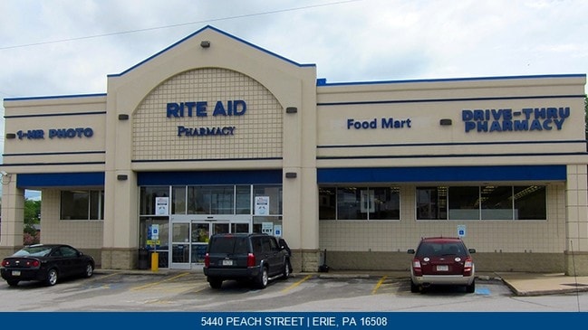
5430 Peach St
33-121-604.0-005.00
Survey For Walnut Capotal Partnership Pe
Storebuilding
5430 PEACH ST 1.602 AC
X
Erie
42049C0203D
Pennsylvania
2025
1.60 AC
2025
Outlying Erie County
011002
Erie
11,540 SF
Erie, PA
DEMOGRAPHICS near 5430 Peach St
1 Mile
3 Mile
5 Mile
2024 Total Population
9,787
66,410
145,463
2029 Population
9,715
65,653
143,852
Pop Growth 2024-2029
(0.74%)
(1.14%)
(1.11%)
Average Age
42
41
41
2024 Total Households
4,505
28,439
61,040
HH Growth 2024-2029
(0.75%)
(1.23%)
(1.19%)
Median Household Inc
$57,580
$57,819
$51,809
Avg Household Size
2.00
2.20
2.20
2024 Avg HH Vehicles
2.00
2.00
1.00
Median Home Value
$165,255
$141,624
$140,704
Median Year Built
1972
1959
1958
Nearby Places
Map Layers
Map Styles
 Street
 Aerial
- Restaurants
- Banks
- Shops
- Fitness
- Groceries
PUBLIC TRANSPORTATION
COMMUTER RAIL
DRIVE
WALK
Distance
9 min
3.5 mi
AIRPORT
Erie International/Tom Ridge Field
DRIVE
WALK
Distance
Erie International/Tom Ridge Field
14 min
7.4 mi
SALE & LEASE HISTORY
LISTING DATE
SALE/LEASE

Jun 08, 2022
For Sale
Aug 17, 2022
For Sale
Nearby Properties
Address
Land Use
TOTAL SIZE
Lot Size
Zoning
Address
Land Use
TOTAL SIZE
Lot Size
Zoning
35,529 SF
84.04 AC
BB
Address
Land Use
TOTAL SIZE
Lot Size
Zoning
31,764 SF
46.83 AC
R3
Address
Land Use
TOTAL SIZE
Lot Size
Zoning
1,121,950 SF
80.70 AC
I1
Address
Land Use
TOTAL SIZE
Lot Size
Zoning
630,344 SF
7.57 AC
RLB
Address
Land Use
TOTAL SIZE
Lot Size
Zoning
24.71 AC
AR
Address
Land Use
TOTAL SIZE
Lot Size
Zoning
8,337 SF
13.31 AC
B1
Address
Land Use
TOTAL SIZE
Lot Size
Zoning
800 SF
10.05 AC
R2
Address
Land Use
TOTAL SIZE
Lot Size
Zoning
14,688 SF
39.53 AC
AR
Address
Land Use
TOTAL SIZE
Lot Size
Zoning
108,080 SF
4.83 AC
AR
Address
Land Use
TOTAL SIZE
Lot Size
Zoning
10,960 SF
29.82 AC
DR
Address
Land Use
TOTAL SIZE
Lot Size
Zoning
22.02 AC
AR
Address
Land Use
TOTAL SIZE
Lot Size
Zoning
227,718 SF
47.43 AC
DB
Address
Land Use
TOTAL SIZE
Lot Size
Zoning
170,870 SF
4.51 AC
RLB
Address
Land Use
TOTAL SIZE
Lot Size
Zoning
117,879 SF
13.47 AC
M1
Address
Land Use
TOTAL SIZE
Lot Size
Zoning
171,306 SF
6.30 AC
AR
Address
Land Use
TOTAL SIZE
Lot Size
Zoning
127,756 SF
7.21 AC
RLB
Address
Land Use
TOTAL SIZE
Lot Size
Zoning
2,754 SF
26.83 AC
DB
Address
Land Use
TOTAL SIZE
Lot Size
Zoning
198,102 SF
27.63 AC
B1
Address
Land Use
TOTAL SIZE
Lot Size
Zoning
80,390 SF
69.53 AC
B1
Address
Land Use
TOTAL SIZE
Lot Size
Zoning
171,966 SF
13.99 AC
RB
Address
Land Use
TOTAL SIZE
Lot Size
Zoning
3,340 SF
37.04 AC
AR
Address
Land Use
TOTAL SIZE
Lot Size
Zoning
38 AC
AR
Address
Land Use
TOTAL SIZE
Lot Size
Zoning
178,236 SF
26.15 AC
RLB
Address
Land Use
TOTAL SIZE
Lot Size
Zoning
88,232 SF
1 AC
RLB
Address
Land Use
TOTAL SIZE
Lot Size
Zoning
100,586 SF
4.89 AC
AB
Address
Land Use
TOTAL SIZE
Lot Size
Zoning
73,078 SF
13.80 AC
B1
Address
Land Use
TOTAL SIZE
Lot Size
Zoning
4,600 SF
50.38 AC
R3
Address
Land Use
TOTAL SIZE
Lot Size
Zoning
100,443 SF
6 AC
B1
Address
Land Use
TOTAL SIZE
Lot Size
Zoning
48,645 SF
3.30 AC
Address
Land Use
TOTAL SIZE
Lot Size
Zoning
125,399 SF
10.93 AC
BB
The World's #1 Commercial Real Estate Marketplace
Connect with us
© 2026 CoStar Group
The information above has been obtained from sources believed reliable. While we do not doubt its accuracy we have not verified it and make no guarantee, warranty or representation about it. It is your responsibility to independently confirm its accuracy and completeness. Any projections, opinions, assumptions, or estimates used are for example only and do not represent the current or future performance of the property. The value of this transaction to you depends on tax and other factors which should be evaluated by your tax, financial, and legal advisors. You and your advisors should conduct a careful, independent investigation of the property to determine to your satisfaction the suitability of the property for your needs.