Property Record
5431 Northfork Rd, Elliston, VA 24087

Property Detail
5431 Northfork Rd
010352
N F R LAFAYETTE GRANGE
Agriculturalland
MONTGOMERY
A1
Virginia
AE The base floodplain where base flood elevations are provided. AE Zones are now used on new format FIRMs instead of A1-A30 Zones.
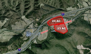
83.02 AC
2025
Blacksburg & Wytheville
2025
Other Market Areas
021400
Blacksburg-Christiansburg-Radford, VA
NEARBY LISTINGS FOR SALE OR LEASE
DEMOGRAPHICS near 5431 Northfork Rd
1 mile
3 mile
5 mile
2025 Total Population
303
2,792
6,397
2030 Population
311
2,833
6,471
Pop Growth 2025-2030
+ 2.64%
+ 1.47%
+ 1.16%
Average Age
40
43
44
2025 Total Households
124
1,103
2,464
HH Growth 2025-2030
+ 2.42%
+ 1.63%
+ 1.26%
Median Household Inc
$34,193
$44,052
$61,302
Avg Household Size
2.50
2.40
2.40
2025 Avg HH Vehicles
2.00
2.00
2.00
Median Home Value
$165,517
$190,056
$220,362
Median Year Built
1971
1980
1980
Nearby Places
Map Layers
Map Styles
 Street
 Aerial
Layers
 Traffic
 Biking
Places
Listings with unknown addresses are not visible on the map
- Restaurants
- Banks
- Shops
- Fitness
- Groceries
PUBLIC TRANSPORTATION
AIRPORT
Roanoke/Blacksburg Regional (Woodrum Field)
Drive
Walk
Distance
Roanoke/Blacksburg Regional (Woodrum Field)
30 min
20.7 mi
Freight Ports
Virginia Port Authority - Richmond
Drive
Walk
Distance
Virginia Port Authority - Richmond
232 min
204.5 mi
Nearby Properties
Address
Land Use
TOTAL SIZE
Lot Size
Zoning
Address
Land Use
TOTAL SIZE
Lot Size
Zoning
375,302 SF
37.71 AC
PIN
Address
Land Use
TOTAL SIZE
Lot Size
Zoning
107,055 SF
34.45 AC
A1
Address
Land Use
TOTAL SIZE
Lot Size
Zoning
98,713 SF
0.02 AC
A1
Address
Land Use
TOTAL SIZE
Lot Size
Zoning
36,873 SF
29.63 AC
I2
Address
Land Use
TOTAL SIZE
Lot Size
Zoning
6,300 SF
617.74 AC
AG3
Address
Land Use
TOTAL SIZE
Lot Size
Zoning
20,163 SF
3.78 AC
GB
Address
Land Use
TOTAL SIZE
Lot Size
Zoning
16,480 SF
10.32 AC
M1
Address
Land Use
TOTAL SIZE
Lot Size
Zoning
32,620 SF
2.61 AC
M1
Address
Land Use
TOTAL SIZE
Lot Size
Zoning
12,297 SF
1.75 AC
M1
Address
Land Use
TOTAL SIZE
Lot Size
Zoning
5.95 AC
M1
Address
Land Use
TOTAL SIZE
Lot Size
Zoning
95.79 AC
A1
Address
Land Use
TOTAL SIZE
Lot Size
Zoning
1.28 AC
GB
Address
Land Use
TOTAL SIZE
Lot Size
Zoning
3,768 SF
36.15 AC
A1
Address
Land Use
TOTAL SIZE
Lot Size
Zoning
9.15 AC
A1
Address
Land Use
TOTAL SIZE
Lot Size
Zoning
4,273 SF
2.98 AC
Address
Land Use
TOTAL SIZE
Lot Size
Zoning
16.70 AC
Address
Land Use
TOTAL SIZE
Lot Size
Zoning
Address
Land Use
TOTAL SIZE
Lot Size
Zoning
1,500 SF
9.84 AC
M1
Address
Land Use
TOTAL SIZE
Lot Size
Zoning
25,000 SF
3.24 AC
M1
Address
Land Use
TOTAL SIZE
Lot Size
Zoning
10,545 SF
2.41 AC
A1
Address
Land Use
TOTAL SIZE
Lot Size
Zoning
4.80 AC
A1
Address
Land Use
TOTAL SIZE
Lot Size
Zoning
2,240 SF
70.50 AC
AG3S
Address
Land Use
TOTAL SIZE
Lot Size
Zoning
110.04 AC
AG1
Address
Land Use
TOTAL SIZE
Lot Size
Zoning
2,005 SF
96 AC
A1
Address
Land Use
TOTAL SIZE
Lot Size
Zoning
Address
Land Use
TOTAL SIZE
Lot Size
Zoning
288.02 AC
A1
Address
Land Use
TOTAL SIZE
Lot Size
Zoning
2.89 AC
GB
Address
Land Use
TOTAL SIZE
Lot Size
Zoning
5,272 SF
23.67 AC
A1
Address
Land Use
TOTAL SIZE
Lot Size
Zoning
1,000 SF
7.89 AC
A1
The World's #1 Commercial Real Estate Marketplace
Connect with us
© 2026 CoStar Group
The information above has been obtained from sources believed reliable. While we do not doubt its accuracy we have not verified it and make no guarantee, warranty or representation about it. It is your responsibility to independently confirm its accuracy and completeness. Any projections, opinions, assumptions, or estimates used are for example only and do not represent the current or future performance of the property. The value of this transaction to you depends on tax and other factors which should be evaluated by your tax, financial, and legal advisors. You and your advisors should conduct a careful, independent investigation of the property to determine to your satisfaction the suitability of the property for your needs.