Property Record
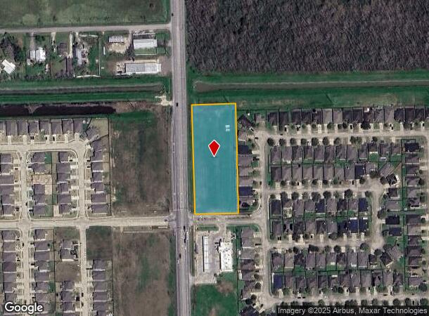
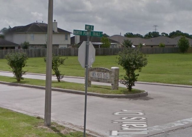
Highway 35, Alvin, TX


NEARBY LISTINGS FOR SALE OR LEASE
Property Detail
Highway 35
Houston-Pasadena-The Woodlands, TX
North Pointe Trails Sec 1 (A0693 I & G N
6767-1000-000
NORTH POINTE TRAILS SEC 1 (A0693 I & G N)(ALVIN) BLK RESERVE B (COMMERCIAL) ACRES 2.62
Vacantlandnec
Brazoria
AO
Texas
48039C0155K
reser
2024
2.62 AC
2025
NASA/Clear Lake
661400
Houston
DEMOGRAPHICS near Highway 35
1 Mile
3 Mile
5 Mile
2024 Total Population
3,631
20,017
73,407
2029 Population
4,066
22,023
79,817
Pop Growth 2024-2029
+ 11.98%
+ 10.02%
+ 8.73%
Average Age
35
37
38
2024 Total Households
1,245
6,643
25,018
HH Growth 2024-2029
+ 11.97%
+ 10.27%
+ 8.98%
Median Household Inc
$81,462
$86,218
$86,618
Avg Household Size
2.90
2.90
2.80
2024 Avg HH Vehicles
2.00
2.00
2.00
Median Home Value
$239,877
$250,299
$277,132
Median Year Built
2010
1994
1992
Nearby Places
Map Layers
Map Styles
 Street
 Aerial
- Restaurants
- Banks
- Shops
- Fitness
- Groceries
PUBLIC TRANSPORTATION
AIRPORT
William P Hobby
DRIVE
WALK
Distance
William P Hobby
26 min
13.3 mi
Freight Ports
Port of Houston
DRIVE
WALK
Distance
Port of Houston
37 min
21.5 mi
SALE & LEASE HISTORY
LISTING DATE
SALE/LEASE

Sep 24, 2016
For Sale
May 13, 2023
For Lease
Nearby Properties
Address
Land Use
TOTAL SIZE
Lot Size
Zoning
Address
Land Use
TOTAL SIZE
Lot Size
Zoning
40.52 AC
0017
Address
Land Use
TOTAL SIZE
Lot Size
Zoning
65,935 SF
81.27 AC
Address
Land Use
TOTAL SIZE
Lot Size
Zoning
84,272 SF
16.93 AC
Address
Land Use
TOTAL SIZE
Lot Size
Zoning
197,506 SF
20.52 AC
Address
Land Use
TOTAL SIZE
Lot Size
Zoning
68,435 SF
5.62 AC
0041
Address
Land Use
TOTAL SIZE
Lot Size
Zoning
111,370 SF
11.10 AC
Address
Land Use
TOTAL SIZE
Lot Size
Zoning
90,044 SF
9.62 AC
Address
Land Use
TOTAL SIZE
Lot Size
Zoning
Address
Land Use
TOTAL SIZE
Lot Size
Zoning
136,700 SF
9.91 AC
0095
Address
Land Use
TOTAL SIZE
Lot Size
Zoning
147,939 SF
38.36 AC
0026
Address
Land Use
TOTAL SIZE
Lot Size
Zoning
89,466 SF
8.61 AC
0109
Address
Land Use
TOTAL SIZE
Lot Size
Zoning
36,596 SF
14.75 AC
Address
Land Use
TOTAL SIZE
Lot Size
Zoning
22,144 SF
9.27 AC
Address
Land Use
TOTAL SIZE
Lot Size
Zoning
1,920 SF
14.94 AC
Address
Land Use
TOTAL SIZE
Lot Size
Zoning
74,002 SF
9.58 AC
Address
Land Use
TOTAL SIZE
Lot Size
Zoning
63,530 SF
8.89 AC
0022
Address
Land Use
TOTAL SIZE
Lot Size
Zoning
94,809 SF
49.01 AC
0103
Address
Land Use
TOTAL SIZE
Lot Size
Zoning
145 SF
20.24 AC
0037
Address
Land Use
TOTAL SIZE
Lot Size
Zoning
18,800 SF
1.08 AC
Address
Land Use
TOTAL SIZE
Lot Size
Zoning
29,200 SF
3.19 AC
Address
Land Use
TOTAL SIZE
Lot Size
Zoning
140 SF
25.06 AC
0008
Address
Land Use
TOTAL SIZE
Lot Size
Zoning
63,250 SF
6.51 AC
0101
Address
Land Use
TOTAL SIZE
Lot Size
Zoning
29.04 AC
0001
Address
Land Use
TOTAL SIZE
Lot Size
Zoning
1,739 SF
5.20 AC
Address
Land Use
TOTAL SIZE
Lot Size
Zoning
22,625 SF
7 AC
Address
Land Use
TOTAL SIZE
Lot Size
Zoning
14.09 AC
Address
Land Use
TOTAL SIZE
Lot Size
Zoning
12,868 SF
1.65 AC
Address
Land Use
TOTAL SIZE
Lot Size
Zoning
49,392 SF
5.44 AC
Address
Land Use
TOTAL SIZE
Lot Size
Zoning
2,169 SF
9.57 AC
SFR
Address
Land Use
TOTAL SIZE
Lot Size
Zoning
32,452 SF
5.46 AC
0086
The World's #1 Commercial Real Estate Marketplace
Connect with us
© 2026 CoStar Group
The information above has been obtained from sources believed reliable. While we do not doubt its accuracy we have not verified it and make no guarantee, warranty or representation about it. It is your responsibility to independently confirm its accuracy and completeness. Any projections, opinions, assumptions, or estimates used are for example only and do not represent the current or future performance of the property. The value of this transaction to you depends on tax and other factors which should be evaluated by your tax, financial, and legal advisors. You and your advisors should conduct a careful, independent investigation of the property to determine to your satisfaction the suitability of the property for your needs.