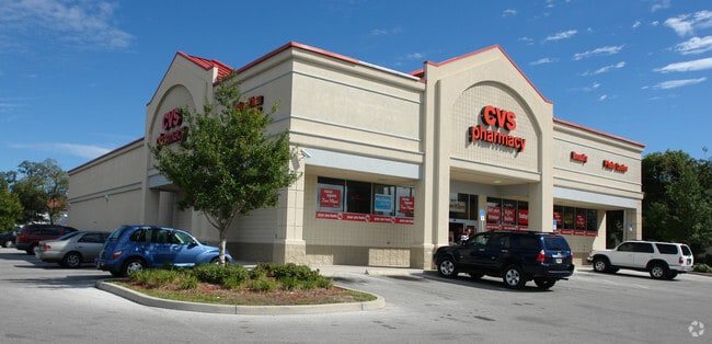
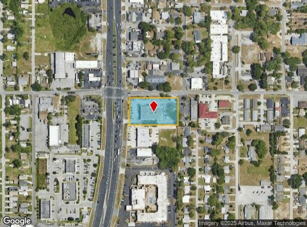
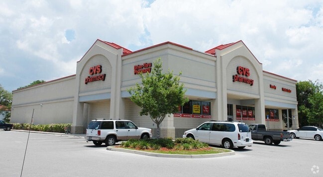
Property Record
5432 Us Highway 19, New Port Richey, FL 34652

NEARBY LISTINGS FOR SALE OR LEASE
Property Detail
5432 Us Highway 19
Tampa-St. Petersburg-Clearwater, FL
Tampa & Tarpon Springs Land Co Sub
08-26-16-0010-05100-0020
TAMPA TARPON SPRINGS LAND COMPANY SUB PB 1 PG 69A N 215 FT OF TR 51 EXC THAT POR THEREOF LYING WITHIN SR NO 55 R/W & EXC N 30 FT THEREOF FOR GULF DR R/W SUBJECT TO A NON EXCLUSIVE EASEMENT PER OR 3949 PG 950 MORE PARTICULARLY DESC AS COM AT NW COR LO
Storebuilding
Pasco
X
Florida
12101C0351G
2
2024
1.56 AC
2025
Pasco County
030800
Tampa/St Petersburg
12,511 SF
DEMOGRAPHICS near 5432 Us Highway 19
1 Mile
3 Mile
5 Mile
2024 Total Population
14,472
78,899
170,886
2029 Population
17,552
95,076
205,581
Pop Growth 2024-2029
+ 21.28%
+ 20.50%
+ 20.30%
Average Age
48
45
44
2024 Total Households
6,936
35,345
74,138
HH Growth 2024-2029
+ 21.38%
+ 20.50%
+ 20.36%
Median Household Inc
$43,706
$44,617
$46,477
Avg Household Size
2.00
2.20
2.20
2024 Avg HH Vehicles
1.00
1.00
2.00
Median Home Value
$222,574
$162,514
$170,071
Median Year Built
1976
1977
1979
Nearby Places
Map Layers
Map Styles
 Street
 Aerial
- Restaurants
- Banks
- Shops
- Fitness
- Groceries
PUBLIC TRANSPORTATION
AIRPORT
Tampa International
DRIVE
WALK
Distance
Tampa International
50 min
29.0 mi
St Pete-Clearwater International
DRIVE
WALK
Distance
St Pete-Clearwater International
50 min
29.2 mi
Freight Ports
Port of Tampa Bay
DRIVE
WALK
Distance
Port of Tampa Bay
63 min
39.1 mi
Nearby Properties
Address
Land Use
TOTAL SIZE
Lot Size
Zoning
Address
Land Use
TOTAL SIZE
Lot Size
Zoning
799,241 SF
88.92 AC
PUD
Address
Land Use
TOTAL SIZE
Lot Size
Zoning
248,561 SF
14.17 AC
C
Address
Land Use
TOTAL SIZE
Lot Size
Zoning
241,429 SF
37.59 AC
C
Address
Land Use
TOTAL SIZE
Lot Size
Zoning
162,716 SF
16.56 AC
MF1
Address
Land Use
TOTAL SIZE
Lot Size
Zoning
171,378 SF
17.35 AC
MF1
Address
Land Use
TOTAL SIZE
Lot Size
Zoning
149,162 SF
3.10 AC
C
Address
Land Use
TOTAL SIZE
Lot Size
Zoning
193,971 SF
4.50 AC
C1
Address
Land Use
TOTAL SIZE
Lot Size
Zoning
163,106 SF
13.97 AC
C
Address
Land Use
TOTAL SIZE
Lot Size
Zoning
145,216 SF
7.58 AC
MF3
Address
Land Use
TOTAL SIZE
Lot Size
Zoning
91,660 SF
16.29 AC
C
Address
Land Use
TOTAL SIZE
Lot Size
Zoning
135,600 SF
13.34 AC
MF1
Address
Land Use
TOTAL SIZE
Lot Size
Zoning
43,469 SF
11.48 AC
MPUD
Address
Land Use
TOTAL SIZE
Lot Size
Zoning
112,703 SF
8.43 AC
C2
Address
Land Use
TOTAL SIZE
Lot Size
Zoning
16,510 SF
41.69 AC
R1
Address
Land Use
TOTAL SIZE
Lot Size
Zoning
77,900 SF
10.52 AC
C2
Address
Land Use
TOTAL SIZE
Lot Size
Zoning
142,856 SF
20 AC
C
Address
Land Use
TOTAL SIZE
Lot Size
Zoning
82,047 SF
21.48 AC
MF2
Address
Land Use
TOTAL SIZE
Lot Size
Zoning
133,304 SF
13.48 AC
C2
Address
Land Use
TOTAL SIZE
Lot Size
Zoning
76,160 SF
6.74 AC
MPUD
Address
Land Use
TOTAL SIZE
Lot Size
Zoning
81,272 SF
47.25 AC
MF2
Address
Land Use
TOTAL SIZE
Lot Size
Zoning
22,216 SF
7.20 AC
C2
Address
Land Use
TOTAL SIZE
Lot Size
Zoning
72,796 SF
2.62 AC
MF3
Address
Land Use
TOTAL SIZE
Lot Size
Zoning
212,308 SF
10.91 AC
MF2
Address
Land Use
TOTAL SIZE
Lot Size
Zoning
65,939 SF
7.23 AC
C2
Address
Land Use
TOTAL SIZE
Lot Size
Zoning
41,156 SF
2.26 AC
C
Address
Land Use
TOTAL SIZE
Lot Size
Zoning
42,059 SF
9.16 AC
C3
Address
Land Use
TOTAL SIZE
Lot Size
Zoning
181,980 SF
11.12 AC
MF2
Address
Land Use
TOTAL SIZE
Lot Size
Zoning
125,834 SF
11.21 AC
C2
Address
Land Use
TOTAL SIZE
Lot Size
Zoning
72,576 SF
8.98 AC
MF2
Address
Land Use
TOTAL SIZE
Lot Size
Zoning
135,857 SF
20.37 AC
C2
The World's #1 Commercial Real Estate Marketplace
Connect with us
© 2025 CoStar Group
The information above has been obtained from sources believed reliable. While we do not doubt its accuracy we have not verified it and make no guarantee, warranty or representation about it. It is your responsibility to independently confirm its accuracy and completeness. Any projections, opinions, assumptions, or estimates used are for example only and do not represent the current or future performance of the property. The value of this transaction to you depends on tax and other factors which should be evaluated by your tax, financial, and legal advisors. You and your advisors should conduct a careful, independent investigation of the property to determine to your satisfaction the suitability of the property for your needs.