Property Record
5433 Fry Rd, Katy, TX 77449


Save to a Folder
{{folder.Name}}
{{folder.ListingIds.length}} Properties
{{folder.ListingIds.length}} Property
Create a New Folder
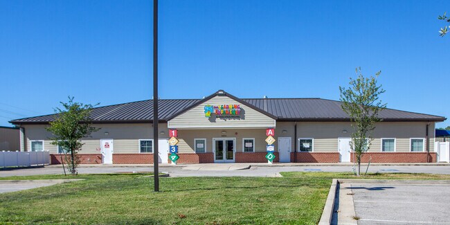
Property Detail
5433 Fry Rd
1354450010001
RES A BLK 1 FRY ROAD STORAGE
Daycare
HARRIS
B and X Area of moderate flood hazard, usually the area between the limits of the 100-year and 500-year floods.
Texas
2025
1.35 AC
2025
Far Katy North
542203
Houston
10,080 SF
Houston-Pasadena-The Woodlands, TX
NEARBY LISTINGS FOR SALE OR LEASE
DEMOGRAPHICS near 5433 Fry Rd
1 mile
3 mile
5 mile
2025 Total Population
24,548
153,284
333,866
2030 Population
26,385
163,116
357,307
Pop Growth 2025-2030
+ 7.48%
+ 6.41%
+ 7.02%
Average Age
33
35
35
2025 Total Households
6,974
44,700
104,522
HH Growth 2025-2030
+ 7.67%
+ 6.59%
+ 7.19%
Median Household Inc
$88,138
$90,882
$89,192
Avg Household Size
3.40
3.40
3.10
2025 Avg HH Vehicles
2.00
2.00
2.00
Median Home Value
$271,138
$263,679
$280,887
Median Year Built
2009
2004
2004
Nearby Places
Map Layers
Map Styles
 Street
 Aerial
Layers
 Traffic
 Biking
Places
Listings with unknown addresses are not visible on the map
- Restaurants
- Banks
- Shops
- Fitness
- Groceries
PUBLIC TRANSPORTATION
AIRPORT
George Bush Intcntl/Houston
Drive
Walk
Distance
George Bush Intcntl/Houston
46 min
30.4 mi
William P Hobby
Drive
Walk
Distance
William P Hobby
60 min
39.6 mi
SALE & LEASE HISTORY
LISTING DATE
SALE/LEASE

Jul 18, 2019
For Sale
Jan 20, 2020
For Sale
Aug 26, 2021
For Lease
Apr 13, 2021
For Lease
Apr 13, 2021
For Sale
Nearby Properties
Address
Land Use
TOTAL SIZE
Lot Size
Zoning
Address
Land Use
TOTAL SIZE
Lot Size
Zoning
838,700 SF
36.68 AC
Address
Land Use
TOTAL SIZE
Lot Size
Zoning
323,609 SF
12.71 AC
Address
Land Use
TOTAL SIZE
Lot Size
Zoning
347,834 SF
15.25 AC
Address
Land Use
TOTAL SIZE
Lot Size
Zoning
335,899 SF
12.62 AC
Address
Land Use
TOTAL SIZE
Lot Size
Zoning
331,263 SF
11.36 AC
Address
Land Use
TOTAL SIZE
Lot Size
Zoning
236,406 SF
11.40 AC
Address
Land Use
TOTAL SIZE
Lot Size
Zoning
262,174 SF
11.64 AC
Address
Land Use
TOTAL SIZE
Lot Size
Zoning
267,766 SF
12.96 AC
Address
Land Use
TOTAL SIZE
Lot Size
Zoning
147,923 SF
11.60 AC
Address
Land Use
TOTAL SIZE
Lot Size
Zoning
171,000 SF
7.08 AC
Address
Land Use
TOTAL SIZE
Lot Size
Zoning
117,860 SF
12.44 AC
Address
Land Use
TOTAL SIZE
Lot Size
Zoning
228,152 SF
22.61 AC
Address
Land Use
TOTAL SIZE
Lot Size
Zoning
150,734 SF
29.67 AC
Address
Land Use
TOTAL SIZE
Lot Size
Zoning
122,880 SF
15 AC
Address
Land Use
TOTAL SIZE
Lot Size
Zoning
99,096 SF
27.51 AC
Address
Land Use
TOTAL SIZE
Lot Size
Zoning
143,950 SF
10.30 AC
Address
Land Use
TOTAL SIZE
Lot Size
Zoning
267,766 SF
12.95 AC
Address
Land Use
TOTAL SIZE
Lot Size
Zoning
163,770 SF
5.08 AC
Address
Land Use
TOTAL SIZE
Lot Size
Zoning
144,736 SF
2.55 AC
Address
Land Use
TOTAL SIZE
Lot Size
Zoning
58,014 SF
22.85 AC
Address
Land Use
TOTAL SIZE
Lot Size
Zoning
52,035 SF
9.23 AC
Address
Land Use
TOTAL SIZE
Lot Size
Zoning
83,750 SF
4.88 AC
Address
Land Use
TOTAL SIZE
Lot Size
Zoning
57,300 SF
7.89 AC
Address
Land Use
TOTAL SIZE
Lot Size
Zoning
1,178 SF
22.91 AC
Address
Land Use
TOTAL SIZE
Lot Size
Zoning
57,453 SF
6.74 AC
Address
Land Use
TOTAL SIZE
Lot Size
Zoning
105,500 SF
5.49 AC
Address
Land Use
TOTAL SIZE
Lot Size
Zoning
57,012 SF
7.10 AC
Address
Land Use
TOTAL SIZE
Lot Size
Zoning
121,560 SF
12.22 AC
Address
Land Use
TOTAL SIZE
Lot Size
Zoning
67,312 SF
6.95 AC
Address
Land Use
TOTAL SIZE
Lot Size
Zoning
46,400 SF
2.78 AC
The World's #1 Commercial Real Estate Marketplace
Connect with us
© 2026 CoStar Group
The information above has been obtained from sources believed reliable. While we do not doubt its accuracy we have not verified it and make no guarantee, warranty or representation about it. It is your responsibility to independently confirm its accuracy and completeness. Any projections, opinions, assumptions, or estimates used are for example only and do not represent the current or future performance of the property. The value of this transaction to you depends on tax and other factors which should be evaluated by your tax, financial, and legal advisors. You and your advisors should conduct a careful, independent investigation of the property to determine to your satisfaction the suitability of the property for your needs.