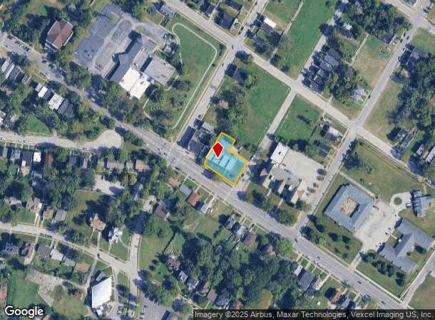
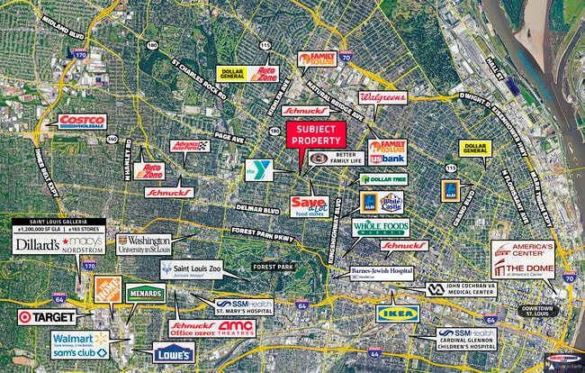
Property Record
5437 Page Blvd, Saint Louis, MO 63112
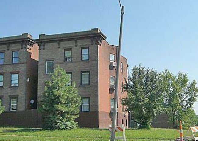

This Property Is For Sale
NEARBY LISTINGS FOR SALE OR LEASE
Property Detail
5437 Page Blvd
St. Louis, MO-IL
Mccormicks Addn
3801-04-0190-0
C. B. 3801 W PAGE 0.468 ACS MCCORMICKS ADDN LOTS 28 THRU 30 W-26 SW-27 & E-1 THRU 5
Multifamilydwelling
St. Louis City
X
Missouri
29189C0217K
28-30
2024
0.47 AC
2025
Hamilton Heights
106600
St. Louis
15,444 SF
DEMOGRAPHICS near 5437 Page Blvd
1 Mile
3 Mile
5 Mile
2024 Total Population
20,709
143,267
332,249
2029 Population
20,442
140,722
323,368
Pop Growth 2024-2029
(1.29%)
(1.78%)
(2.67%)
Average Age
40
39
39
2024 Total Households
9,076
63,723
153,622
HH Growth 2024-2029
(1.38%)
(2.14%)
(2.92%)
Median Household Inc
$40,450
$44,157
$50,799
Avg Household Size
2.10
2.00
2.00
2024 Avg HH Vehicles
1.00
1.00
1.00
Median Home Value
$148,522
$140,225
$183,591
Median Year Built
1947
1948
1948
Nearby Places
- Restaurants
- Banks
- Shops
- Fitness
- Groceries
PUBLIC TRANSPORTATION
COMMUTER RAIL
Wellston (Lambert Airport Shiloh-Scott - St. Louis MetroLink (MetroLink))
DRIVE
WALK
Distance
Wellston (Lambert Airport Shiloh-Scott - St. Louis MetroLink (MetroLink))
4 min
1.5 mi
Delmar Loop (Lambert Airport Shiloh-Scott - St. Louis MetroLink (MetroLink))
DRIVE
WALK
Distance
Delmar Loop (Lambert Airport Shiloh-Scott - St. Louis MetroLink (MetroLink))
4 min
1.9 mi
AIRPORT
St Louis Lambert International
DRIVE
WALK
Distance
St Louis Lambert International
16 min
9.0 mi
Scott AFB/Midamerica St Louis
DRIVE
WALK
Distance
Scott AFB/Midamerica St Louis
50 min
31.8 mi
Nearby Properties
Address
Land Use
TOTAL SIZE
Lot Size
Zoning
Address
Land Use
TOTAL SIZE
Lot Size
Zoning
684,846 SF
90.65 AC
R6
Address
Land Use
TOTAL SIZE
Lot Size
Zoning
Address
Land Use
TOTAL SIZE
Lot Size
Zoning
136.92 AC
AI
Address
Land Use
TOTAL SIZE
Lot Size
Zoning
124.96 AC
J
Address
Land Use
TOTAL SIZE
Lot Size
Zoning
558,158 SF
45.66 AC
14R-2
Address
Land Use
TOTAL SIZE
Lot Size
Zoning
833,982 SF
18.70 AC
GB
Address
Land Use
TOTAL SIZE
Lot Size
Zoning
152.07 AC
L
Address
Land Use
TOTAL SIZE
Lot Size
Zoning
52,556 SF
68.80 AC
14R-2
Address
Land Use
TOTAL SIZE
Lot Size
Zoning
1,361,485 SF
5.45 AC
E
Address
Land Use
TOTAL SIZE
Lot Size
Zoning
390,010 SF
13.25 AC
R6
Address
Land Use
TOTAL SIZE
Lot Size
Zoning
7,780 SF
15.61 AC
14R-2
Address
Land Use
TOTAL SIZE
Lot Size
Zoning
624,049 SF
20.78 AC
K
Address
Land Use
TOTAL SIZE
Lot Size
Zoning
7.94 AC
D
Address
Land Use
TOTAL SIZE
Lot Size
Zoning
Address
Land Use
TOTAL SIZE
Lot Size
Zoning
6.05 AC
J
Address
Land Use
TOTAL SIZE
Lot Size
Zoning
423,303 SF
9.97 AC
H
Address
Land Use
TOTAL SIZE
Lot Size
Zoning
306,459 SF
4.79 AC
H
Address
Land Use
TOTAL SIZE
Lot Size
Zoning
225,920 SF
2.02 AC
H
Address
Land Use
TOTAL SIZE
Lot Size
Zoning
15.27 AC
A
Address
Land Use
TOTAL SIZE
Lot Size
Zoning
358,243 SF
3.02 AC
H
Address
Land Use
TOTAL SIZE
Lot Size
Zoning
248,809 SF
3.23 AC
H
Address
Land Use
TOTAL SIZE
Lot Size
Zoning
189,841 SF
4.18 AC
K
Address
Land Use
TOTAL SIZE
Lot Size
Zoning
309,734 SF
3.41 AC
E
Address
Land Use
TOTAL SIZE
Lot Size
Zoning
191,584 SF
1.76 AC
K
Address
Land Use
TOTAL SIZE
Lot Size
Zoning
19.40 AC
57PA
Address
Land Use
TOTAL SIZE
Lot Size
Zoning
191,352 SF
4.41 AC
K
Address
Land Use
TOTAL SIZE
Lot Size
Zoning
177,974 SF
2.29 AC
J
Address
Land Use
TOTAL SIZE
Lot Size
Zoning
117,270 SF
0.21 AC
49C2
Address
Land Use
TOTAL SIZE
Lot Size
Zoning
184,183 SF
1.96 AC
J
Address
Land Use
TOTAL SIZE
Lot Size
Zoning
101,200 SF
1.10 AC
E
The World's #1 Commercial Real Estate Marketplace
Connect with us
© 2025 CoStar Group
The information above has been obtained from sources believed reliable. While we do not doubt its accuracy we have not verified it and make no guarantee, warranty or representation about it. It is your responsibility to independently confirm its accuracy and completeness. Any projections, opinions, assumptions, or estimates used are for example only and do not represent the current or future performance of the property. The value of this transaction to you depends on tax and other factors which should be evaluated by your tax, financial, and legal advisors. You and your advisors should conduct a careful, independent investigation of the property to determine to your satisfaction the suitability of the property for your needs.