Property Record
544 E Main St, Ashland, OH 44805
NEARBY LISTINGS FOR SALE OR LEASE
-
-
View all Ashland listings for sale on LoopNet.com
Property Detail
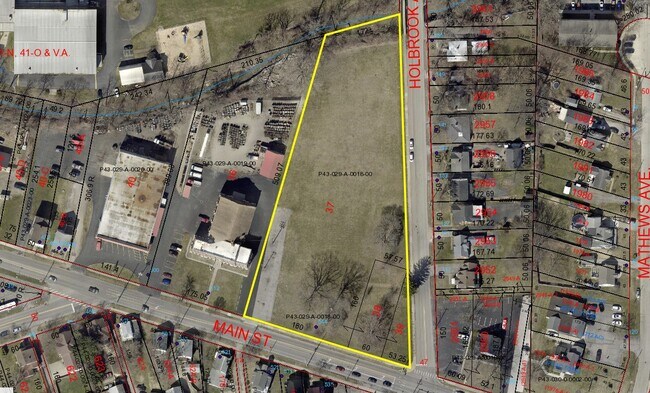
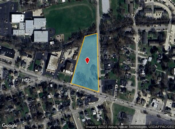
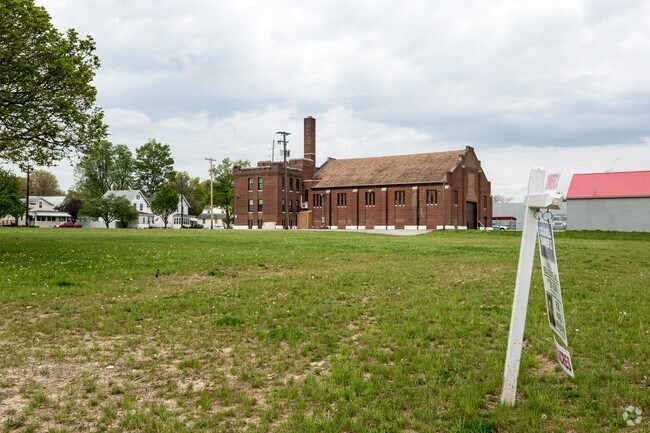
544 E Main St
P43-029-A-0018-00
North Ashland
Publicschool
544 E MAIN ST R=29A LOTS 37 38 & 39 (OSBORN ELEMENTARY SCHOOL)
AE
Ashland
39005C0231E
Ohio
2024
3.14 AC
2024
Ohio North Area
970800
Other Market Areas
35,778 SF
Ashland, OH
DEMOGRAPHICS near 544 E Main St
1 Mile
3 Mile
5 Mile
2024 Total Population
9,361
22,608
26,999
2029 Population
9,434
22,791
27,144
Pop Growth 2024-2029
+ 0.78%
+ 0.81%
+ 0.54%
Average Age
39
42
42
2024 Total Households
3,952
9,416
11,088
HH Growth 2024-2029
+ 0.76%
+ 0.79%
+ 0.54%
Median Household Inc
$47,047
$55,077
$56,340
Avg Household Size
2.20
2.20
2.30
2024 Avg HH Vehicles
2.00
2.00
2.00
Median Home Value
$107,565
$137,491
$144,505
Median Year Built
1949
1959
1963
Nearby Places
Map Layers
Map Styles
 Street
 Aerial
- Restaurants
- Banks
- Shops
- Fitness
- Groceries
SALE & LEASE HISTORY
LISTING DATE
SALE/LEASE

May 04, 2017
For Sale
Feb 15, 2023
For Sale
Nearby Properties
Address
Land Use
TOTAL SIZE
Lot Size
Zoning
Address
Land Use
TOTAL SIZE
Lot Size
Zoning
7,737 SF
16.67 AC
Address
Land Use
TOTAL SIZE
Lot Size
Zoning
125,000 SF
2.57 AC
Address
Land Use
TOTAL SIZE
Lot Size
Zoning
3,786 SF
11.90 AC
Address
Land Use
TOTAL SIZE
Lot Size
Zoning
3,988 SF
15.28 AC
Address
Land Use
TOTAL SIZE
Lot Size
Zoning
602,490 SF
30.07 AC
Address
Land Use
TOTAL SIZE
Lot Size
Zoning
792 SF
47.90 AC
Address
Land Use
TOTAL SIZE
Lot Size
Zoning
15,279 SF
69.95 AC
Address
Land Use
TOTAL SIZE
Lot Size
Zoning
104,076 SF
5 AC
Address
Land Use
TOTAL SIZE
Lot Size
Zoning
37,974 SF
7.35 AC
Address
Land Use
TOTAL SIZE
Lot Size
Zoning
39,229 SF
13.47 AC
Address
Land Use
TOTAL SIZE
Lot Size
Zoning
62,667 SF
2.80 AC
Address
Land Use
TOTAL SIZE
Lot Size
Zoning
215,905 SF
38.12 AC
Address
Land Use
TOTAL SIZE
Lot Size
Zoning
210,000 SF
23 AC
Address
Land Use
TOTAL SIZE
Lot Size
Zoning
0.22 AC
Address
Land Use
TOTAL SIZE
Lot Size
Zoning
74,191 SF
6.81 AC
Address
Land Use
TOTAL SIZE
Lot Size
Zoning
242,225 SF
20 AC
Address
Land Use
TOTAL SIZE
Lot Size
Zoning
95,413 SF
0.20 AC
Address
Land Use
TOTAL SIZE
Lot Size
Zoning
71,621 SF
6.19 AC
Address
Land Use
TOTAL SIZE
Lot Size
Zoning
57,097 SF
25.50 AC
Address
Land Use
TOTAL SIZE
Lot Size
Zoning
93,760 SF
132.09 AC
Address
Land Use
TOTAL SIZE
Lot Size
Zoning
234,000 SF
13.02 AC
Address
Land Use
TOTAL SIZE
Lot Size
Zoning
1,411 SF
10.44 AC
Address
Land Use
TOTAL SIZE
Lot Size
Zoning
14,296 SF
5.45 AC
Address
Land Use
TOTAL SIZE
Lot Size
Zoning
220,099 SF
14.68 AC
Address
Land Use
TOTAL SIZE
Lot Size
Zoning
50,000 SF
14.43 AC
Address
Land Use
TOTAL SIZE
Lot Size
Zoning
46,137 SF
0.20 AC
Address
Land Use
TOTAL SIZE
Lot Size
Zoning
576 SF
19.97 AC
Address
Land Use
TOTAL SIZE
Lot Size
Zoning
40,091 SF
0.17 AC
Address
Land Use
TOTAL SIZE
Lot Size
Zoning
8,283 SF
9 AC
Address
Land Use
TOTAL SIZE
Lot Size
Zoning
19,069 SF
8.09 AC
The World's #1 Commercial Real Estate Marketplace
Connect with us
© 2026 CoStar Group
The information above has been obtained from sources believed reliable. While we do not doubt its accuracy we have not verified it and make no guarantee, warranty or representation about it. It is your responsibility to independently confirm its accuracy and completeness. Any projections, opinions, assumptions, or estimates used are for example only and do not represent the current or future performance of the property. The value of this transaction to you depends on tax and other factors which should be evaluated by your tax, financial, and legal advisors. You and your advisors should conduct a careful, independent investigation of the property to determine to your satisfaction the suitability of the property for your needs.