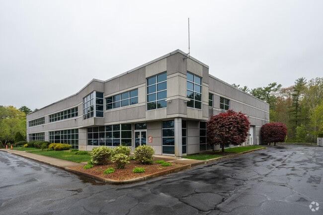
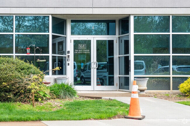
Property Record
544 Paramount Dr, Raynham, MA 02767

Property Detail
544 Paramount Dr
RAYN-000015-000176-000003D
Bristol
Officebuilding
Massachusetts
B and X Area of moderate flood hazard, usually the area between the limits of the 100-year and 500-year floods.
3d
2025
3.01 AC
2025
Attleboro/New Bedford
612202
Boston
22,388 SF
Providence-Warwick, RI-MA
NEARBY LISTINGS FOR SALE OR LEASE
DEMOGRAPHICS near 544 Paramount Dr
1 mile
3 mile
5 mile
2025 Total Population
3,098
23,339
79,060
2030 Population
3,218
23,891
80,509
Pop Growth 2025-2030
+ 3.87%
+ 2.37%
+ 1.83%
Average Age
46
42
41
2025 Total Households
1,208
8,714
30,535
HH Growth 2025-2030
+ 4.06%
+ 2.42%
+ 1.85%
Median Household Inc
$105,978
$106,279
$83,090
Avg Household Size
2.50
2.60
2.50
2025 Avg HH Vehicles
2.00
2.00
2.00
Median Home Value
$526,575
$478,594
$473,134
Median Year Built
1991
1983
1973
Nearby Places
Map Layers
Map Styles
 Street
 Aerial
Transit
 Traffic
 Biking
Places
Listings with unknown addresses are not visible on the map
- Restaurants
- Banks
- Shops
- Fitness
- Groceries
PUBLIC TRANSPORTATION
COMMUTER RAIL
Middleborough/Lakeville (Middleborough/Lakeville Line - Massachusetts Bay Transportation Authority Commuter Rail (Purple Line))
Drive
Walk
Distance
Middleborough/Lakeville (Middleborough/Lakeville Line - Massachusetts Bay Transportation Authority Commuter Rail (Purple Line))
13 min
6.9 mi
AIRPORT
Rhode Island Tf Green International
Drive
Walk
Distance
Rhode Island Tf Green International
53 min
29.7 mi
Freight Ports
Port of New Bedford Harbor
Drive
Walk
Distance
Port of New Bedford Harbor
35 min
24.6 mi
Nearby Properties
Address
Land Use
TOTAL SIZE
Lot Size
Zoning
Address
Land Use
TOTAL SIZE
Lot Size
Zoning
850,008 SF
172.89 AC
INDUST
Address
Land Use
TOTAL SIZE
Lot Size
Zoning
133,652 SF
2 AC
Address
Land Use
TOTAL SIZE
Lot Size
Zoning
815,324 SF
88.80 AC
Address
Land Use
TOTAL SIZE
Lot Size
Zoning
Address
Land Use
TOTAL SIZE
Lot Size
Zoning
117,752 SF
22.37 AC
Address
Land Use
TOTAL SIZE
Lot Size
Zoning
217,011 SF
73.55 AC
OPSPAC
Address
Land Use
TOTAL SIZE
Lot Size
Zoning
27 AC
INDUST
Address
Land Use
TOTAL SIZE
Lot Size
Zoning
136,122 SF
49.49 AC
Address
Land Use
TOTAL SIZE
Lot Size
Zoning
67,588 SF
18.81 AC
SUBRES
Address
Land Use
TOTAL SIZE
Lot Size
Zoning
178.18 AC
OPSPAC
Address
Land Use
TOTAL SIZE
Lot Size
Zoning
14.43 AC
Address
Land Use
TOTAL SIZE
Lot Size
Zoning
351,320 SF
42 AC
INDUST
Address
Land Use
TOTAL SIZE
Lot Size
Zoning
137,710 SF
26.66 AC
Address
Land Use
TOTAL SIZE
Lot Size
Zoning
127,092 SF
9.37 AC
INDUST
Address
Land Use
TOTAL SIZE
Lot Size
Zoning
6.53 AC
URBRES
Address
Land Use
TOTAL SIZE
Lot Size
Zoning
45,786 SF
16 AC
URBRES
Address
Land Use
TOTAL SIZE
Lot Size
Zoning
10,680 SF
79.73 AC
Address
Land Use
TOTAL SIZE
Lot Size
Zoning
206,139 SF
21.55 AC
Address
Land Use
TOTAL SIZE
Lot Size
Zoning
16 AC
URBRES
Address
Land Use
TOTAL SIZE
Lot Size
Zoning
124,465 SF
15.08 AC
INDUST
Address
Land Use
TOTAL SIZE
Lot Size
Zoning
1,783 SF
9.29 AC
Address
Land Use
TOTAL SIZE
Lot Size
Zoning
107,794 SF
12.51 AC
Address
Land Use
TOTAL SIZE
Lot Size
Zoning
13 AC
HIWABZ
Address
Land Use
TOTAL SIZE
Lot Size
Zoning
137,952 SF
20.99 AC
INDUST
Address
Land Use
TOTAL SIZE
Lot Size
Zoning
103,233 SF
41.66 AC
BIZDIS
Address
Land Use
TOTAL SIZE
Lot Size
Zoning
133,773 SF
24.50 AC
Address
Land Use
TOTAL SIZE
Lot Size
Zoning
5 AC
OFFDIS
Address
Land Use
TOTAL SIZE
Lot Size
Zoning
86,176 SF
7.14 AC
INDUST
Address
Land Use
TOTAL SIZE
Lot Size
Zoning
12.38 AC
INDUST
Address
Land Use
TOTAL SIZE
Lot Size
Zoning
16.06 AC
The World's #1 Commercial Real Estate Marketplace
Connect with us
© 2026 CoStar Group
The information above has been obtained from sources believed reliable. While we do not doubt its accuracy we have not verified it and make no guarantee, warranty or representation about it. It is your responsibility to independently confirm its accuracy and completeness. Any projections, opinions, assumptions, or estimates used are for example only and do not represent the current or future performance of the property. The value of this transaction to you depends on tax and other factors which should be evaluated by your tax, financial, and legal advisors. You and your advisors should conduct a careful, independent investigation of the property to determine to your satisfaction the suitability of the property for your needs.