Property Record
544 Park St, Thermopolis, WY 82443

Save to a Folder
{{folder.Name}}
{{folder.ListingIds.length}} Properties
{{folder.ListingIds.length}} Property
Create a New Folder
Property Detail
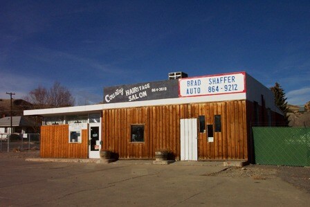
544 Park St
Other Market Areas
RYANS ADDN BLK 56 LOTS 13-17 & W/2 LOT 18 COMMERCIAL
2212
Hot Springs
Restaurantbuilding
Wyoming
2025
13-18
2026
0.54 AC
967800
Wyoming Area
1,870 SF
NEARBY LISTINGS FOR SALE OR LEASE
-
-
View all Thermopolis listings for sale on LoopNet.com
DEMOGRAPHICS near 544 Park St
1 mile
3 mile
5 mile
2025 Total Population
2,622
3,640
3,999
2030 Population
2,672
3,692
4,045
Pop Growth 2025-2030
+ 1.91%
+ 1.43%
+ 1.15%
Average Age
45
45
45
2025 Total Households
1,196
1,620
1,771
HH Growth 2025-2030
+ 1.92%
+ 1.48%
+ 1.24%
Median Household Inc
$65,625
$67,941
$67,264
Avg Household Size
2.10
2.20
2.20
2025 Avg HH Vehicles
2.00
2.00
2.00
Median Home Value
$212,015
$224,203
$227,822
Median Year Built
1964
1967
1968
Nearby Places
Map Layers
Map Styles
 Street
 Aerial
Layers
 Traffic
 Biking
Places
Listings with unknown addresses are not visible on the map
- Restaurants
- Banks
- Shops
- Fitness
- Groceries
Nearby Properties
Address
Land Use
TOTAL SIZE
Lot Size
Zoning
Address
Land Use
TOTAL SIZE
Lot Size
Zoning
54,066 SF
87 SF
Address
Land Use
TOTAL SIZE
Lot Size
Zoning
27,387 SF
4.65 AC
Address
Land Use
TOTAL SIZE
Lot Size
Zoning
20,914 SF
87 SF
Address
Land Use
TOTAL SIZE
Lot Size
Zoning
20,447 SF
3.28 AC
Address
Land Use
TOTAL SIZE
Lot Size
Zoning
7,701 SF
1.16 AC
Address
Land Use
TOTAL SIZE
Lot Size
Zoning
18,576 SF
1.16 AC
Address
Land Use
TOTAL SIZE
Lot Size
Zoning
6,754 SF
0.29 AC
Address
Land Use
TOTAL SIZE
Lot Size
Zoning
17,964 SF
7.48 AC
Address
Land Use
TOTAL SIZE
Lot Size
Zoning
18,240 SF
5.99 AC
Address
Land Use
TOTAL SIZE
Lot Size
Zoning
12,697 SF
1.15 AC
Address
Land Use
TOTAL SIZE
Lot Size
Zoning
4,455 SF
0.29 AC
Address
Land Use
TOTAL SIZE
Lot Size
Zoning
11,948 SF
1.70 AC
Address
Land Use
TOTAL SIZE
Lot Size
Zoning
16,480 SF
87 SF
Address
Land Use
TOTAL SIZE
Lot Size
Zoning
3,702 SF
0.58 AC
Address
Land Use
TOTAL SIZE
Lot Size
Zoning
46,207 SF
4.12 AC
Address
Land Use
TOTAL SIZE
Lot Size
Zoning
47.34 AC
Address
Land Use
TOTAL SIZE
Lot Size
Zoning
10,500 SF
3.44 AC
Address
Land Use
TOTAL SIZE
Lot Size
Zoning
16,250 SF
2.32 AC
Address
Land Use
TOTAL SIZE
Lot Size
Zoning
7,370 SF
1.12 AC
Address
Land Use
TOTAL SIZE
Lot Size
Zoning
13,367 SF
1.03 AC
Address
Land Use
TOTAL SIZE
Lot Size
Zoning
Address
Land Use
TOTAL SIZE
Lot Size
Zoning
3,100 SF
174 SF
Address
Land Use
TOTAL SIZE
Lot Size
Zoning
13,056 SF
2.13 AC
Address
Land Use
TOTAL SIZE
Lot Size
Zoning
8,537 SF
0.36 AC
Address
Land Use
TOTAL SIZE
Lot Size
Zoning
7,900 SF
0.29 AC
Address
Land Use
TOTAL SIZE
Lot Size
Zoning
9,483 SF
0.19 AC
Address
Land Use
TOTAL SIZE
Lot Size
Zoning
3,212 SF
0.56 AC
Address
Land Use
TOTAL SIZE
Lot Size
Zoning
4,800 SF
0.45 AC
Address
Land Use
TOTAL SIZE
Lot Size
Zoning
2,847 SF
0.45 AC
Address
Land Use
TOTAL SIZE
Lot Size
Zoning
7,391 SF
0.14 AC
The World's #1 Commercial Real Estate Marketplace
Connect with us
© 2026 CoStar Group
The information above has been obtained from sources believed reliable. While we do not doubt its accuracy we have not verified it and make no guarantee, warranty or representation about it. It is your responsibility to independently confirm its accuracy and completeness. Any projections, opinions, assumptions, or estimates used are for example only and do not represent the current or future performance of the property. The value of this transaction to you depends on tax and other factors which should be evaluated by your tax, financial, and legal advisors. You and your advisors should conduct a careful, independent investigation of the property to determine to your satisfaction the suitability of the property for your needs.