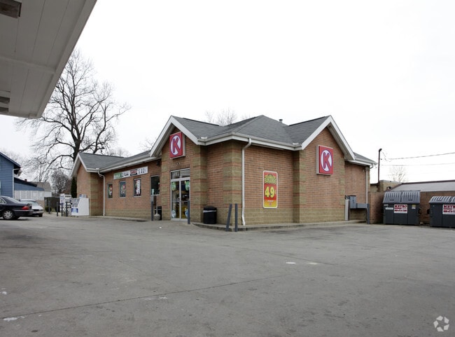
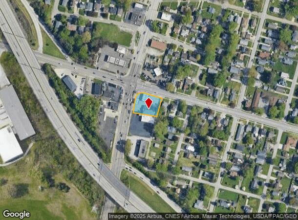
Property Record
544 W Waterloo Rd, Akron, OH 44314

NEARBY LISTINGS FOR SALE OR LEASE
Property Detail
544 W Waterloo Rd
Akron, OH
Nesmith Lake Heights Allot No 2
67-62998
NESMITH LAKE HEIGHTS ALLOT NO 2 LOTS 680-685 ALL INCL LESS P T FOR RD LOTS 686-688 ALL INCL PB 26 PG 54-60 .4146 AC
Servicestation
Summit
X
Ohio
39153C0195F
2
2023
0.42 AC
2025
Akron
505900
Cleveland
3,124 SF
DEMOGRAPHICS near 544 W Waterloo Rd
1 Mile
3 Mile
5 Mile
2024 Total Population
6,303
75,060
166,515
2029 Population
6,272
74,637
165,857
Pop Growth 2024-2029
(0.49%)
(0.56%)
(0.40%)
Average Age
41
40
40
2024 Total Households
2,793
32,805
71,573
HH Growth 2024-2029
(0.54%)
(0.63%)
(0.43%)
Median Household Inc
$44,079
$42,609
$41,985
Avg Household Size
2.20
2.20
2.20
2024 Avg HH Vehicles
2.00
2.00
2.00
Median Home Value
$69,226
$87,478
$104,421
Median Year Built
1952
1953
1953
Nearby Places
Map Layers
Map Styles
 Street
 Aerial
- Restaurants
- Banks
- Shops
- Fitness
- Groceries
PUBLIC TRANSPORTATION
COMMUTER RAIL
Akron Northside (National Park Scenic Railway - Cuyahoga Valley Scenic Railroad)
DRIVE
WALK
Distance
Akron Northside (National Park Scenic Railway - Cuyahoga Valley Scenic Railroad)
12 min
5.1 mi
Big Bend (National Park Scenic Railway - Cuyahoga Valley Scenic Railroad)
DRIVE
WALK
Distance
Big Bend (National Park Scenic Railway - Cuyahoga Valley Scenic Railroad)
18 min
7.7 mi
AIRPORT
Akron-Canton Regional
DRIVE
WALK
Distance
Akron-Canton Regional
16 min
11.9 mi
Freight Ports
Port of Toledo
DRIVE
WALK
Distance
Port of Toledo
161 min
136.7 mi
Nearby Properties
Address
Land Use
TOTAL SIZE
Lot Size
Zoning
Address
Land Use
TOTAL SIZE
Lot Size
Zoning
1,397,532 SF
92.95 AC
Address
Land Use
TOTAL SIZE
Lot Size
Zoning
Address
Land Use
TOTAL SIZE
Lot Size
Zoning
203,458 SF
10.41 AC
Address
Land Use
TOTAL SIZE
Lot Size
Zoning
9.19 AC
Address
Land Use
TOTAL SIZE
Lot Size
Zoning
132,611 SF
3.56 AC
Address
Land Use
TOTAL SIZE
Lot Size
Zoning
91,678 SF
5.24 AC
Address
Land Use
TOTAL SIZE
Lot Size
Zoning
423,125 SF
5.57 AC
Address
Land Use
TOTAL SIZE
Lot Size
Zoning
Address
Land Use
TOTAL SIZE
Lot Size
Zoning
227,634 SF
21.46 AC
Address
Land Use
TOTAL SIZE
Lot Size
Zoning
Address
Land Use
TOTAL SIZE
Lot Size
Zoning
Address
Land Use
TOTAL SIZE
Lot Size
Zoning
184,791 SF
3.25 AC
Address
Land Use
TOTAL SIZE
Lot Size
Zoning
154,926 SF
12.38 AC
Address
Land Use
TOTAL SIZE
Lot Size
Zoning
127,297 SF
6.03 AC
Address
Land Use
TOTAL SIZE
Lot Size
Zoning
121,006 SF
6.09 AC
Address
Land Use
TOTAL SIZE
Lot Size
Zoning
22,977 SF
263.47 AC
Address
Land Use
TOTAL SIZE
Lot Size
Zoning
57,180 SF
6.67 AC
Address
Land Use
TOTAL SIZE
Lot Size
Zoning
Address
Land Use
TOTAL SIZE
Lot Size
Zoning
148.10 AC
Address
Land Use
TOTAL SIZE
Lot Size
Zoning
51,520 SF
2.70 AC
Address
Land Use
TOTAL SIZE
Lot Size
Zoning
Address
Land Use
TOTAL SIZE
Lot Size
Zoning
258,686 SF
19.52 AC
Address
Land Use
TOTAL SIZE
Lot Size
Zoning
81,108 SF
3.86 AC
Address
Land Use
TOTAL SIZE
Lot Size
Zoning
130,893 SF
11.70 AC
Address
Land Use
TOTAL SIZE
Lot Size
Zoning
59,492 SF
5.51 AC
Address
Land Use
TOTAL SIZE
Lot Size
Zoning
112,894 SF
12.26 AC
Address
Land Use
TOTAL SIZE
Lot Size
Zoning
61,897 SF
2.75 AC
Address
Land Use
TOTAL SIZE
Lot Size
Zoning
77,444 SF
13.02 AC
Address
Land Use
TOTAL SIZE
Lot Size
Zoning
Address
Land Use
TOTAL SIZE
Lot Size
Zoning
16,604 SF
248.86 AC
The World's #1 Commercial Real Estate Marketplace
Connect with us
© 2025 CoStar Group
The information above has been obtained from sources believed reliable. While we do not doubt its accuracy we have not verified it and make no guarantee, warranty or representation about it. It is your responsibility to independently confirm its accuracy and completeness. Any projections, opinions, assumptions, or estimates used are for example only and do not represent the current or future performance of the property. The value of this transaction to you depends on tax and other factors which should be evaluated by your tax, financial, and legal advisors. You and your advisors should conduct a careful, independent investigation of the property to determine to your satisfaction the suitability of the property for your needs.