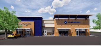
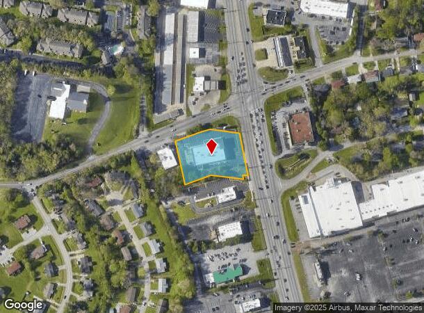
Property Record
5441 Highway 153, Hixson, TN 37343

NEARBY LISTINGS FOR SALE OR LEASE
Property Detail
5441 Highway 153
Chattanooga, TN-GA
Houston Hixson Home
099M-H-032
LT 1 ECKERD'S TRACT ON HWY 153 PB 62 PG 272
Medicalclinic
Hamilton
X
Tennessee
47065C0238G
1
2025
1.45 AC
2025
Outlying Hamilton County
010433
Chattanooga
12,890 SF
DEMOGRAPHICS near 5441 Highway 153
1 Mile
3 Mile
5 Mile
2024 Total Population
6,138
33,890
79,170
2029 Population
6,513
36,127
84,410
Pop Growth 2024-2029
+ 6.11%
+ 6.60%
+ 6.62%
Average Age
40
42
42
2024 Total Households
2,591
14,563
33,655
HH Growth 2024-2029
+ 6.29%
+ 6.80%
+ 6.84%
Median Household Inc
$65,641
$67,311
$72,164
Avg Household Size
2.30
2.20
2.30
2024 Avg HH Vehicles
2.00
2.00
2.00
Median Home Value
$202,128
$223,663
$256,285
Median Year Built
1977
1974
1977
Nearby Places
Map Layers
Map Styles
 Street
 Aerial
- Restaurants
- Banks
- Shops
- Fitness
- Groceries
PUBLIC TRANSPORTATION
AIRPORT
Lovell Field
DRIVE
WALK
Distance
Lovell Field
19 min
11.8 mi
SALE & LEASE HISTORY
LISTING DATE
SALE/LEASE

Nov 12, 2018
For Lease
Jan 10, 2020
For Lease
Feb 08, 2024
For Lease
Nearby Properties
Address
Land Use
TOTAL SIZE
Lot Size
Zoning
Address
Land Use
TOTAL SIZE
Lot Size
Zoning
103.37 AC
Address
Land Use
TOTAL SIZE
Lot Size
Zoning
197,214 SF
19.39 AC
R4
Address
Land Use
TOTAL SIZE
Lot Size
Zoning
286,637 SF
20.40 AC
Address
Land Use
TOTAL SIZE
Lot Size
Zoning
309,974 SF
20.57 AC
R3
Address
Land Use
TOTAL SIZE
Lot Size
Zoning
292,937 SF
21.50 AC
R1
Address
Land Use
TOTAL SIZE
Lot Size
Zoning
48,465 SF
21.50 AC
Address
Land Use
TOTAL SIZE
Lot Size
Zoning
7,693 SF
115.99 AC
R1
Address
Land Use
TOTAL SIZE
Lot Size
Zoning
68,635 SF
44.47 AC
Address
Land Use
TOTAL SIZE
Lot Size
Zoning
139,820 SF
12.67 AC
R3
Address
Land Use
TOTAL SIZE
Lot Size
Zoning
149,270 SF
9.25 AC
R4
Address
Land Use
TOTAL SIZE
Lot Size
Zoning
21,330 SF
15 AC
M1
Address
Land Use
TOTAL SIZE
Lot Size
Zoning
189,000 SF
10.39 AC
Address
Land Use
TOTAL SIZE
Lot Size
Zoning
182,466 SF
20.95 AC
R5
Address
Land Use
TOTAL SIZE
Lot Size
Zoning
341,649 SF
38.44 AC
C2
Address
Land Use
TOTAL SIZE
Lot Size
Zoning
186,480 SF
11.83 AC
Address
Land Use
TOTAL SIZE
Lot Size
Zoning
88,449 SF
4 AC
Address
Land Use
TOTAL SIZE
Lot Size
Zoning
20,880 SF
14.13 AC
R3
Address
Land Use
TOTAL SIZE
Lot Size
Zoning
91,520 SF
10.99 AC
C2
Address
Land Use
TOTAL SIZE
Lot Size
Zoning
125,681 SF
5.55 AC
M3
Address
Land Use
TOTAL SIZE
Lot Size
Zoning
215,672 SF
21.28 AC
Address
Land Use
TOTAL SIZE
Lot Size
Zoning
7,440 SF
12.74 AC
Address
Land Use
TOTAL SIZE
Lot Size
Zoning
76,589 SF
9.71 AC
R4
Address
Land Use
TOTAL SIZE
Lot Size
Zoning
147,631 SF
21.20 AC
M1
Address
Land Use
TOTAL SIZE
Lot Size
Zoning
Address
Land Use
TOTAL SIZE
Lot Size
Zoning
31,511 SF
5.48 AC
Address
Land Use
TOTAL SIZE
Lot Size
Zoning
160,149 SF
12.89 AC
C2
Address
Land Use
TOTAL SIZE
Lot Size
Zoning
56 AC
9999
Address
Land Use
TOTAL SIZE
Lot Size
Zoning
47,343 SF
4.06 AC
Address
Land Use
TOTAL SIZE
Lot Size
Zoning
79,260 SF
10.92 AC
C2
Address
Land Use
TOTAL SIZE
Lot Size
Zoning
87,930 SF
4 AC
The World's #1 Commercial Real Estate Marketplace
Connect with us
© 2026 CoStar Group
The information above has been obtained from sources believed reliable. While we do not doubt its accuracy we have not verified it and make no guarantee, warranty or representation about it. It is your responsibility to independently confirm its accuracy and completeness. Any projections, opinions, assumptions, or estimates used are for example only and do not represent the current or future performance of the property. The value of this transaction to you depends on tax and other factors which should be evaluated by your tax, financial, and legal advisors. You and your advisors should conduct a careful, independent investigation of the property to determine to your satisfaction the suitability of the property for your needs.