Property Record
5443 W 70Th Pl, Chicago, IL 60638
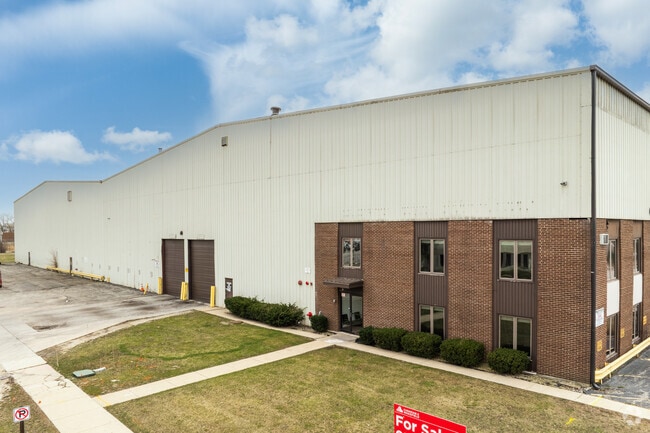
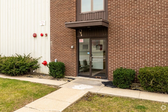
Property Detail
5443 W 70Th Pl
Chicago-Naperville-Elgin, IL-IN
S2 S21 T38N R13E 3P
19-21-302-013-0000
COOK
Industrialgeneral
Illinois
B and X Area of moderate flood hazard, usually the area between the limits of the 100-year and 500-year floods.
6-8
2023
0.42 AC
2025
Near SW Suburbs
820901
Chicago
NEARBY LISTINGS FOR SALE OR LEASE
DEMOGRAPHICS near 5443 W 70Th Pl
1 mile
3 mile
5 mile
2025 Total Population
7,724
203,482
525,269
2030 Population
7,678
200,906
517,014
Pop Growth 2025-2030
(0.60%)
(1.27%)
(1.57%)
Average Age
39
39
39
2025 Total Households
2,638
63,918
171,510
HH Growth 2025-2030
(0.83%)
(1.44%)
(1.62%)
Median Household Inc
$79,410
$77,305
$70,171
Avg Household Size
2.90
3.10
2.90
2025 Avg HH Vehicles
2.00
2.00
2.00
Median Home Value
$251,787
$261,622
$255,514
Median Year Built
1960
1957
1957
Nearby Places
Map Layers
Map Styles
 Street
 Aerial
Layers
 Traffic
 Biking
Places
Listings with unknown addresses are not visible on the map
- Restaurants
- Banks
- Shops
- Fitness
- Groceries
PUBLIC TRANSPORTATION
COMMUTER RAIL
Ashburn Station (SouthWest Service - Northeast Illinois Regional Commuter Railroad (Metra))
Drive
Walk
Distance
Ashburn Station (SouthWest Service - Northeast Illinois Regional Commuter Railroad (Metra))
9 min
3.9 mi
Wrightwood Station (SouthWest Service - Northeast Illinois Regional Commuter Railroad (Metra))
Drive
Walk
Distance
Wrightwood Station (SouthWest Service - Northeast Illinois Regional Commuter Railroad (Metra))
9 min
3.9 mi
AIRPORT
Chicago Midway International
Drive
Walk
Distance
Chicago Midway International
9 min
4.0 mi
Chicago O'Hare International
Drive
Walk
Distance
Chicago O'Hare International
44 min
28.7 mi
Freight Ports
Port Milwaukee
Drive
Walk
Distance
Port Milwaukee
123 min
94.0 mi
SALE & LEASE HISTORY
LISTING DATE
SALE/LEASE

Feb 20, 2025
For Sale
Feb 20, 2025
For Lease
Aug 08, 2023
For Lease
Aug 08, 2023
For Sale
Nearby Properties
Address
Land Use
TOTAL SIZE
Lot Size
Zoning
Address
Land Use
TOTAL SIZE
Lot Size
Zoning
1,269,112 SF
39.99 AC
M2-1
Address
Land Use
TOTAL SIZE
Lot Size
Zoning
2,155,128 SF
63.23 AC
PMD13
Address
Land Use
TOTAL SIZE
Lot Size
Zoning
124,324 SF
11.26 AC
Address
Land Use
TOTAL SIZE
Lot Size
Zoning
798,998 SF
B3-2
Address
Land Use
TOTAL SIZE
Lot Size
Zoning
72,090 SF
10.19 AC
Address
Land Use
TOTAL SIZE
Lot Size
Zoning
101,034 SF
1.92 AC
Address
Land Use
TOTAL SIZE
Lot Size
Zoning
111,830 SF
2.16 AC
Address
Land Use
TOTAL SIZE
Lot Size
Zoning
266,580 SF
29.50 AC
Address
Land Use
TOTAL SIZE
Lot Size
Zoning
292,978 SF
22.31 AC
Address
Land Use
TOTAL SIZE
Lot Size
Zoning
796,454 SF
25.68 AC
PMD13
Address
Land Use
TOTAL SIZE
Lot Size
Zoning
1,615,006 SF
41.91 AC
PMD13
Address
Land Use
TOTAL SIZE
Lot Size
Zoning
19.48 AC
Address
Land Use
TOTAL SIZE
Lot Size
Zoning
198,190 SF
15 AC
Address
Land Use
TOTAL SIZE
Lot Size
Zoning
102,534 SF
3.87 AC
Address
Land Use
TOTAL SIZE
Lot Size
Zoning
139,493 SF
9.06 AC
PD 965
Address
Land Use
TOTAL SIZE
Lot Size
Zoning
1.16 AC
Address
Land Use
TOTAL SIZE
Lot Size
Zoning
45,196 SF
1.28 AC
Address
Land Use
TOTAL SIZE
Lot Size
Zoning
134,078 SF
17.31 AC
Address
Land Use
TOTAL SIZE
Lot Size
Zoning
PD 610
Address
Land Use
TOTAL SIZE
Lot Size
Zoning
397,288 SF
10.18 AC
Address
Land Use
TOTAL SIZE
Lot Size
Zoning
148,474 SF
17.68 AC
Address
Land Use
TOTAL SIZE
Lot Size
Zoning
93,438 SF
3.13 AC
Address
Land Use
TOTAL SIZE
Lot Size
Zoning
86,703 SF
3.37 AC
Address
Land Use
TOTAL SIZE
Lot Size
Zoning
256,416 SF
9.07 AC
Address
Land Use
TOTAL SIZE
Lot Size
Zoning
90,808 SF
3.27 AC
Address
Land Use
TOTAL SIZE
Lot Size
Zoning
8,400 SF
0.53 AC
M1-1
Address
Land Use
TOTAL SIZE
Lot Size
Zoning
470,160 SF
23.66 AC
Address
Land Use
TOTAL SIZE
Lot Size
Zoning
127,197 SF
10.43 AC
Address
Land Use
TOTAL SIZE
Lot Size
Zoning
202,309 SF
13.02 AC
Address
Land Use
TOTAL SIZE
Lot Size
Zoning
367,185 SF
25 AC
The World's #1 Commercial Real Estate Marketplace
Connect with us
© 2026 CoStar Group
The information above has been obtained from sources believed reliable. While we do not doubt its accuracy we have not verified it and make no guarantee, warranty or representation about it. It is your responsibility to independently confirm its accuracy and completeness. Any projections, opinions, assumptions, or estimates used are for example only and do not represent the current or future performance of the property. The value of this transaction to you depends on tax and other factors which should be evaluated by your tax, financial, and legal advisors. You and your advisors should conduct a careful, independent investigation of the property to determine to your satisfaction the suitability of the property for your needs.