Property Record
5443 W Us Highway 34, Loveland, CO 80537
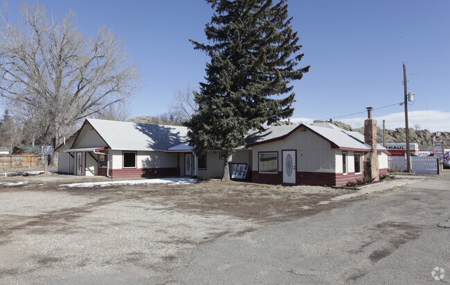

Property Detail
5443 W Us Highway 34
95074-00-015
BEG AT PT WH BEARS N 44 53 46 W 736.94 FT FROM SE COR 7-5-69; TH N 01 12 57 E 138.69 FT, TH N 84 39 W 292.82 FT, S 91.41 FT TO NRLY R/W LN STATE HWY, TH S 75 30 59 E 298.07 FT TPOB (C14N003637E)
Officebuilding
LARIMER
T
Colorado
AE The base floodplain where base flood elevations are provided. AE Zones are now used on new format FIRMs instead of A1-A30 Zones.
0.77 AC
2024
Outer Larimer County
2025
Denver
001808
Fort Collins-Loveland, CO
3,276 SF
NEARBY LISTINGS FOR SALE OR LEASE
-
-
View all Loveland listings for lease on LoopNet.com
DEMOGRAPHICS near 5443 W Us Highway 34
1 mile
3 mile
5 mile
2025 Total Population
1,381
23,485
64,106
2030 Population
1,423
23,999
65,435
Pop Growth 2025-2030
+ 3.04%
+ 2.19%
+ 2.07%
Average Age
50
46
44
2025 Total Households
583
9,578
26,797
HH Growth 2025-2030
+ 3.09%
+ 2.24%
+ 2.15%
Median Household Inc
$107,276
$92,666
$85,200
Avg Household Size
2.30
2.40
2.30
2025 Avg HH Vehicles
3.00
2.00
2.00
Median Home Value
$709,940
$607,020
$491,427
Median Year Built
1992
1990
1985
Nearby Places
Map Layers
Map Styles
 Street
 Aerial
Layers
 Traffic
 Biking
Places
Listings with unknown addresses are not visible on the map
- Restaurants
- Banks
- Shops
- Fitness
- Groceries
SALE & LEASE HISTORY
LISTING DATE
SALE/LEASE

Sep 25, 2016
For Lease
Nearby Properties
Address
Land Use
TOTAL SIZE
Lot Size
Zoning
Address
Land Use
TOTAL SIZE
Lot Size
Zoning
59.21 AC
FA
Address
Land Use
TOTAL SIZE
Lot Size
Zoning
93,908 SF
28.86 AC
R1
Address
Land Use
TOTAL SIZE
Lot Size
Zoning
50,715 SF
10.23 AC
R1
Address
Land Use
TOTAL SIZE
Lot Size
Zoning
48,000 SF
10 AC
P58
Address
Land Use
TOTAL SIZE
Lot Size
Zoning
50,098 SF
4.49 AC
B
Address
Land Use
TOTAL SIZE
Lot Size
Zoning
31,800 SF
2.99 AC
B
Address
Land Use
TOTAL SIZE
Lot Size
Zoning
60,896 SF
8.72 AC
I
Address
Land Use
TOTAL SIZE
Lot Size
Zoning
147,858 SF
37.02 AC
I
Address
Land Use
TOTAL SIZE
Lot Size
Zoning
79,051 SF
39.44 AC
I
Address
Land Use
TOTAL SIZE
Lot Size
Zoning
107,050 SF
6.70 AC
B
Address
Land Use
TOTAL SIZE
Lot Size
Zoning
31,847 SF
4.67 AC
Address
Land Use
TOTAL SIZE
Lot Size
Zoning
89,748 SF
8.02 AC
B
Address
Land Use
TOTAL SIZE
Lot Size
Zoning
40,936 SF
3.06 AC
I
Address
Land Use
TOTAL SIZE
Lot Size
Zoning
43,964 SF
9.40 AC
Address
Land Use
TOTAL SIZE
Lot Size
Zoning
37,500 SF
4.56 AC
R1
Address
Land Use
TOTAL SIZE
Lot Size
Zoning
76,161 SF
5.76 AC
B
Address
Land Use
TOTAL SIZE
Lot Size
Zoning
41,963 SF
1.39 AC
B
Address
Land Use
TOTAL SIZE
Lot Size
Zoning
14,634 SF
1.54 AC
B
Address
Land Use
TOTAL SIZE
Lot Size
Zoning
31,884 SF
2.22 AC
B
Address
Land Use
TOTAL SIZE
Lot Size
Zoning
33,330 SF
7.58 AC
R1E
Address
Land Use
TOTAL SIZE
Lot Size
Zoning
6,589 SF
25 AC
Address
Land Use
TOTAL SIZE
Lot Size
Zoning
17,108 SF
1.53 AC
B
Address
Land Use
TOTAL SIZE
Lot Size
Zoning
33,156 SF
5.95 AC
B
Address
Land Use
TOTAL SIZE
Lot Size
Zoning
25,558 SF
2.57 AC
B
Address
Land Use
TOTAL SIZE
Lot Size
Zoning
10,985 SF
3 AC
Address
Land Use
TOTAL SIZE
Lot Size
Zoning
36.98 AC
FA
Address
Land Use
TOTAL SIZE
Lot Size
Zoning
9,471 SF
1.38 AC
FA1
Address
Land Use
TOTAL SIZE
Lot Size
Zoning
28,177 SF
0.75 AC
Address
Land Use
TOTAL SIZE
Lot Size
Zoning
22,475 SF
2.10 AC
C
Address
Land Use
TOTAL SIZE
Lot Size
Zoning
13,530 SF
5.21 AC
R1
The World's #1 Commercial Real Estate Marketplace
Connect with us
© 2026 CoStar Group
The information above has been obtained from sources believed reliable. While we do not doubt its accuracy we have not verified it and make no guarantee, warranty or representation about it. It is your responsibility to independently confirm its accuracy and completeness. Any projections, opinions, assumptions, or estimates used are for example only and do not represent the current or future performance of the property. The value of this transaction to you depends on tax and other factors which should be evaluated by your tax, financial, and legal advisors. You and your advisors should conduct a careful, independent investigation of the property to determine to your satisfaction the suitability of the property for your needs.