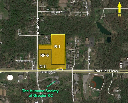
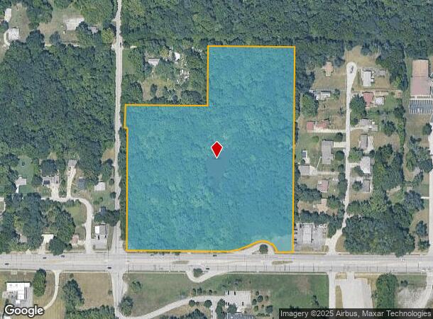
Property Record
5444 Parallel Pkwy, Kansas City, KS 66104
NEARBY LISTINGS FOR SALE OR LEASE
Property Detail
5444 Parallel Pkwy
Kansas City, MO-KS
Wyandotte
917813
Kansas
Sfr
12.29 AC
X
Kansas City KS
29095C0125G
Kansas City
DEMOGRAPHICS near 5444 Parallel Pkwy
1 Mile
3 Mile
5 Mile
2024 Total Population
7,414
51,196
116,756
2029 Population
7,245
50,127
114,784
Pop Growth 2024-2029
(2.28%)
(2.09%)
(1.69%)
Average Age
36
36
36
2024 Total Households
2,571
18,129
41,260
HH Growth 2024-2029
(2.33%)
(2.10%)
(1.71%)
Median Household Inc
$50,820
$51,707
$50,975
Avg Household Size
2.70
2.70
2.70
2024 Avg HH Vehicles
2.00
2.00
2.00
Median Home Value
$126,903
$120,610
$130,740
Median Year Built
1960
1959
1958
Nearby Places
Map Layers
Map Styles
 Street
 Aerial
- Restaurants
- Banks
- Shops
- Fitness
- Groceries
PUBLIC TRANSPORTATION
AIRPORT
Kansas City International
DRIVE
WALK
Distance
Kansas City International
25 min
19.6 mi
Freight Ports
Tulsa Port Of Catoosa
DRIVE
WALK
Distance
Tulsa Port Of Catoosa
267 min
239.0 mi
SALE & LEASE HISTORY
LISTING DATE
SALE/LEASE

Feb 15, 2021
For Sale
Nearby Properties
Address
Land Use
TOTAL SIZE
Lot Size
Zoning
Address
Land Use
TOTAL SIZE
Lot Size
Zoning
872,064 SF
119.39 AC
Address
Land Use
TOTAL SIZE
Lot Size
Zoning
347,991 SF
51.92 AC
1KMC
Address
Land Use
TOTAL SIZE
Lot Size
Zoning
542,696 SF
28.12 AC
Address
Land Use
TOTAL SIZE
Lot Size
Zoning
264,254 SF
56.62 AC
KR1
Address
Land Use
TOTAL SIZE
Lot Size
Zoning
309,440 SF
120.73 AC
KR1
Address
Land Use
TOTAL SIZE
Lot Size
Zoning
346,224 SF
28.44 AC
Address
Land Use
TOTAL SIZE
Lot Size
Zoning
407,936 SF
37.46 AC
1
Address
Land Use
TOTAL SIZE
Lot Size
Zoning
396,532 SF
31.98 AC
Address
Land Use
TOTAL SIZE
Lot Size
Zoning
241,816 SF
20.03 AC
Address
Land Use
TOTAL SIZE
Lot Size
Zoning
224,020 SF
24.72 AC
KR1
Address
Land Use
TOTAL SIZE
Lot Size
Zoning
88,396 SF
23.79 AC
Address
Land Use
TOTAL SIZE
Lot Size
Zoning
139,499 SF
20.51 AC
KR1B
Address
Land Use
TOTAL SIZE
Lot Size
Zoning
122,217 SF
23.87 AC
KR2
Address
Land Use
TOTAL SIZE
Lot Size
Zoning
71,326 SF
6.31 AC
KR1
Address
Land Use
TOTAL SIZE
Lot Size
Zoning
75,309 SF
19.40 AC
KR1
Address
Land Use
TOTAL SIZE
Lot Size
Zoning
383,232 SF
15.93 AC
LU1
Address
Land Use
TOTAL SIZE
Lot Size
Zoning
54,578 SF
12.01 AC
KR1
Address
Land Use
TOTAL SIZE
Lot Size
Zoning
139,495 SF
35.01 AC
KR1
Address
Land Use
TOTAL SIZE
Lot Size
Zoning
158,011 SF
26.66 AC
Address
Land Use
TOTAL SIZE
Lot Size
Zoning
39,641 SF
70.67 AC
Address
Land Use
TOTAL SIZE
Lot Size
Zoning
132,724 SF
20.84 AC
KC1
Address
Land Use
TOTAL SIZE
Lot Size
Zoning
45,968 SF
2.58 AC
KR2
Address
Land Use
TOTAL SIZE
Lot Size
Zoning
207,491 SF
616.94 AC
KR1
Address
Land Use
TOTAL SIZE
Lot Size
Zoning
62,068 SF
17.75 AC
KR1
Address
Land Use
TOTAL SIZE
Lot Size
Zoning
19,392 SF
2.77 AC
KCP1
Address
Land Use
TOTAL SIZE
Lot Size
Zoning
1,032,141 SF
45.80 AC
LU1
Address
Land Use
TOTAL SIZE
Lot Size
Zoning
53,029 SF
6.50 AC
KR1B
Address
Land Use
TOTAL SIZE
Lot Size
Zoning
31,185 SF
4.72 AC
KC1
Address
Land Use
TOTAL SIZE
Lot Size
Zoning
39,588 SF
16.33 AC
KR1
Address
Land Use
TOTAL SIZE
Lot Size
Zoning
164,462 SF
23.15 AC
The World's #1 Commercial Real Estate Marketplace
Connect with us
© 2026 CoStar Group
The information above has been obtained from sources believed reliable. While we do not doubt its accuracy we have not verified it and make no guarantee, warranty or representation about it. It is your responsibility to independently confirm its accuracy and completeness. Any projections, opinions, assumptions, or estimates used are for example only and do not represent the current or future performance of the property. The value of this transaction to you depends on tax and other factors which should be evaluated by your tax, financial, and legal advisors. You and your advisors should conduct a careful, independent investigation of the property to determine to your satisfaction the suitability of the property for your needs.