Property Record
5445 Spring St, Mount Pleasant, WI 53406
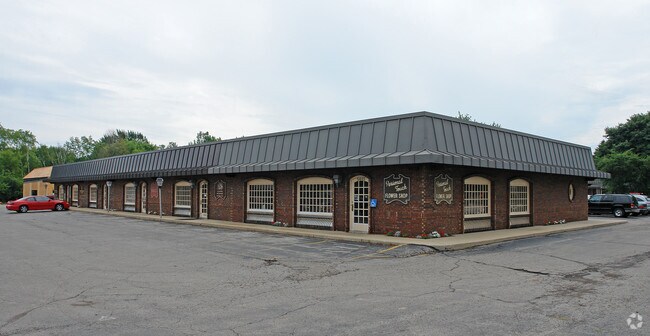

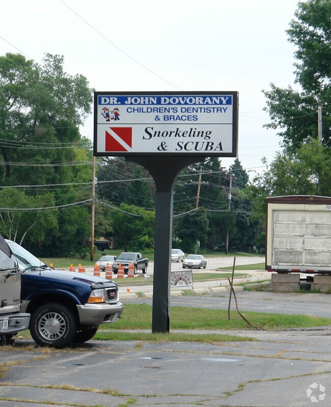
Property Detail
5445 Spring St
Racine-Mount Pleasant, WI
PT NE1/4 COM 991 N OF SEC CEN N271 E16 NE34 E127 E9 S296 W161 W16 TO POB **TOTAL ACRES** 1.20
151-032212053000
Racine
Commercialnec
Wisconsin
B and X Area of moderate flood hazard, usually the area between the limits of the 100-year and 500-year floods.
1.20 AC
2025
Racine East
2025
Milwaukee/Madison
001102
NEARBY LISTINGS FOR SALE OR LEASE
DEMOGRAPHICS near 5445 Spring St
1 mile
3 mile
5 mile
2025 Total Population
8,089
75,494
132,001
2030 Population
8,080
76,085
133,023
Pop Growth 2025-2030
(0.11%)
+ 0.78%
+ 0.77%
Average Age
44
39
40
2025 Total Households
3,586
30,684
53,186
HH Growth 2025-2030
(0.06%)
+ 0.80%
+ 0.78%
Median Household Inc
$90,256
$67,023
$68,157
Avg Household Size
2.20
2.40
2.40
2025 Avg HH Vehicles
2.00
2.00
2.00
Median Home Value
$257,536
$187,957
$213,544
Median Year Built
1978
1961
1963
Nearby Places
Map Layers
Map Styles
 Street
 Aerial
Layers
 Traffic
 Biking
Places
Listings with unknown addresses are not visible on the map
- Restaurants
- Banks
- Shops
- Fitness
- Groceries
PUBLIC TRANSPORTATION
COMMUTER RAIL
Drive
Walk
Distance
11 min
5.0 mi
AIRPORT
General Mitchell International
Drive
Walk
Distance
General Mitchell International
32 min
18.8 mi
Freight Ports
Port Milwaukee
Drive
Walk
Distance
Port Milwaukee
37 min
24.7 mi
Nearby Properties
Address
Land Use
TOTAL SIZE
Lot Size
Zoning
Address
Land Use
TOTAL SIZE
Lot Size
Zoning
47.01 AC
M-1
Address
Land Use
TOTAL SIZE
Lot Size
Zoning
9.40 AC
B-3
Address
Land Use
TOTAL SIZE
Lot Size
Zoning
61,744 SF
42.23 AC
OI
Address
Land Use
TOTAL SIZE
Lot Size
Zoning
57.80 AC
M1
Address
Land Use
TOTAL SIZE
Lot Size
Zoning
Address
Land Use
TOTAL SIZE
Lot Size
Zoning
Address
Land Use
TOTAL SIZE
Lot Size
Zoning
5.74 AC
Address
Land Use
TOTAL SIZE
Lot Size
Zoning
Address
Land Use
TOTAL SIZE
Lot Size
Zoning
Address
Land Use
TOTAL SIZE
Lot Size
Zoning
6.77 AC
PUL
Address
Land Use
TOTAL SIZE
Lot Size
Zoning
94.35 AC
Address
Land Use
TOTAL SIZE
Lot Size
Zoning
24.04 AC
BP
Address
Land Use
TOTAL SIZE
Lot Size
Zoning
10.02 AC
Address
Land Use
TOTAL SIZE
Lot Size
Zoning
164,201 SF
17 AC
B2
Address
Land Use
TOTAL SIZE
Lot Size
Zoning
Address
Land Use
TOTAL SIZE
Lot Size
Zoning
Address
Land Use
TOTAL SIZE
Lot Size
Zoning
Address
Land Use
TOTAL SIZE
Lot Size
Zoning
Address
Land Use
TOTAL SIZE
Lot Size
Zoning
Address
Land Use
TOTAL SIZE
Lot Size
Zoning
Address
Land Use
TOTAL SIZE
Lot Size
Zoning
Address
Land Use
TOTAL SIZE
Lot Size
Zoning
Address
Land Use
TOTAL SIZE
Lot Size
Zoning
22.72 AC
Address
Land Use
TOTAL SIZE
Lot Size
Zoning
76.18 AC
Address
Land Use
TOTAL SIZE
Lot Size
Zoning
Address
Land Use
TOTAL SIZE
Lot Size
Zoning
19,200 SF
4.97 AC
003
Address
Land Use
TOTAL SIZE
Lot Size
Zoning
Address
Land Use
TOTAL SIZE
Lot Size
Zoning
2.10 AC
Address
Land Use
TOTAL SIZE
Lot Size
Zoning
Address
Land Use
TOTAL SIZE
Lot Size
Zoning
20.57 AC
The World's #1 Commercial Real Estate Marketplace
Connect with us
© 2026 CoStar Group
The information above has been obtained from sources believed reliable. While we do not doubt its accuracy we have not verified it and make no guarantee, warranty or representation about it. It is your responsibility to independently confirm its accuracy and completeness. Any projections, opinions, assumptions, or estimates used are for example only and do not represent the current or future performance of the property. The value of this transaction to you depends on tax and other factors which should be evaluated by your tax, financial, and legal advisors. You and your advisors should conduct a careful, independent investigation of the property to determine to your satisfaction the suitability of the property for your needs.