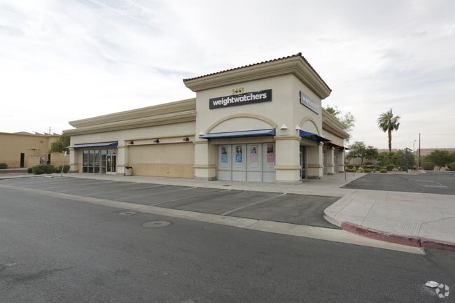
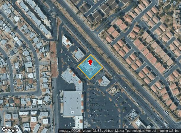
Property Record
5446 Boulder Hwy, Las Vegas, NV 89122
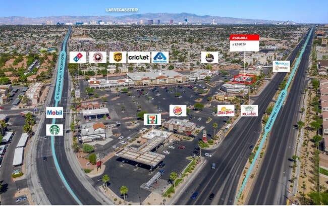
Current Lease Availabilities
NEARBY LISTINGS FOR SALE OR LEASE
Property Detail
5446 Boulder Hwy
Las Vegas-Henderson-North Las Vegas, NV
Boulder Crossings
161-21-814-014
BOULDER CROSSINGS PLAT BOOK 88 PAGE 82 PT LOT 1
Storebuilding
Clark
X
Nevada
32003C2585F
1
2025
0.83 AC
2025
East Las Vegas
001718
Las Vegas
6,230 SF
DEMOGRAPHICS near 5446 Boulder Hwy
1 Mile
3 Mile
5 Mile
2024 Total Population
24,262
158,930
380,726
2029 Population
25,727
169,505
406,730
Pop Growth 2024-2029
+ 6.04%
+ 6.65%
+ 6.83%
Average Age
38
39
39
2024 Total Households
8,744
59,797
143,362
HH Growth 2024-2029
+ 5.90%
+ 6.61%
+ 6.84%
Median Household Inc
$44,131
$50,615
$52,543
Avg Household Size
2.70
2.60
2.60
2024 Avg HH Vehicles
2.00
2.00
2.00
Median Home Value
$230,917
$275,858
$299,453
Median Year Built
1985
1991
1989
Nearby Places
Map Layers
Map Styles
 Street
 Aerial
- Restaurants
- Banks
- Shops
- Fitness
- Groceries
PUBLIC TRANSPORTATION
AIRPORT
Harry Reid International
DRIVE
WALK
Distance
Harry Reid International
14 min
7.2 mi
Boulder City Municipal
DRIVE
WALK
Distance
Boulder City Municipal
27 min
18.4 mi
Nearby Properties
Address
Land Use
TOTAL SIZE
Lot Size
Zoning
Address
Land Use
TOTAL SIZE
Lot Size
Zoning
251,075 SF
24.28 AC
Address
Land Use
TOTAL SIZE
Lot Size
Zoning
265,609 SF
47.36 AC
H1
Address
Land Use
TOTAL SIZE
Lot Size
Zoning
3,356 SF
336.99 AC
RE
Address
Land Use
TOTAL SIZE
Lot Size
Zoning
345,133 SF
27.01 AC
H1
Address
Land Use
TOTAL SIZE
Lot Size
Zoning
14,840 SF
38.54 AC
CC
Address
Land Use
TOTAL SIZE
Lot Size
Zoning
20,727 SF
319.86 AC
PF
Address
Land Use
TOTAL SIZE
Lot Size
Zoning
280 AC
PF
Address
Land Use
TOTAL SIZE
Lot Size
Zoning
8,047 SF
17.42 AC
Address
Land Use
TOTAL SIZE
Lot Size
Zoning
410,084 SF
16.74 AC
RH24
Address
Land Use
TOTAL SIZE
Lot Size
Zoning
404,030 SF
20.17 AC
RE
Address
Land Use
TOTAL SIZE
Lot Size
Zoning
8,168 SF
15.22 AC
Address
Land Use
TOTAL SIZE
Lot Size
Zoning
513,085 SF
53.27 AC
C2
Address
Land Use
TOTAL SIZE
Lot Size
Zoning
100.25 AC
RS1
Address
Land Use
TOTAL SIZE
Lot Size
Zoning
8,891 SF
11.59 AC
Address
Land Use
TOTAL SIZE
Lot Size
Zoning
3,289 SF
22.36 AC
R3
Address
Land Use
TOTAL SIZE
Lot Size
Zoning
198.15 AC
PF
Address
Land Use
TOTAL SIZE
Lot Size
Zoning
38,764 SF
12.66 AC
H1
Address
Land Use
TOTAL SIZE
Lot Size
Zoning
137.65 AC
Address
Land Use
TOTAL SIZE
Lot Size
Zoning
38.36 AC
Address
Land Use
TOTAL SIZE
Lot Size
Zoning
4,460 SF
27.52 AC
Address
Land Use
TOTAL SIZE
Lot Size
Zoning
6,670 SF
14.18 AC
C2
Address
Land Use
TOTAL SIZE
Lot Size
Zoning
35.42 AC
PS
Address
Land Use
TOTAL SIZE
Lot Size
Zoning
314,454 SF
22.94 AC
CC
Address
Land Use
TOTAL SIZE
Lot Size
Zoning
4.93 AC
Address
Land Use
TOTAL SIZE
Lot Size
Zoning
43.37 AC
RS1
Address
Land Use
TOTAL SIZE
Lot Size
Zoning
6,659 SF
6.05 AC
H1
Address
Land Use
TOTAL SIZE
Lot Size
Zoning
7,908 SF
24.13 AC
R4
Address
Land Use
TOTAL SIZE
Lot Size
Zoning
4.18 AC
PF
Address
Land Use
TOTAL SIZE
Lot Size
Zoning
82,405 SF
5.49 AC
PS
Address
Land Use
TOTAL SIZE
Lot Size
Zoning
3,074 SF
18.46 AC
RH24
The World's #1 Commercial Real Estate Marketplace
Connect with us
© 2026 CoStar Group
The information above has been obtained from sources believed reliable. While we do not doubt its accuracy we have not verified it and make no guarantee, warranty or representation about it. It is your responsibility to independently confirm its accuracy and completeness. Any projections, opinions, assumptions, or estimates used are for example only and do not represent the current or future performance of the property. The value of this transaction to you depends on tax and other factors which should be evaluated by your tax, financial, and legal advisors. You and your advisors should conduct a careful, independent investigation of the property to determine to your satisfaction the suitability of the property for your needs.