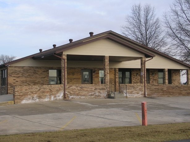
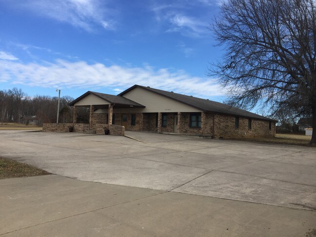
Property Record
5448 N 2Nd Ave, Ozark, MO 65721

NEARBY LISTINGS FOR SALE OR LEASE
Property Detail
5448 N 2Nd Ave
Springfield, MO
Shelton Place
11-0.1-02-000-000-014.000
LOT 10 SHELTON PLACE A PT BEG. 363.51 W SEC SE1/4 NW1/4: N 488.93, W 295 S 488.93 E
Commercialnec
Christian
X
Missouri
29043C0079D
10
2023
3 AC
2024
East Christian County
020310
Springfield
5,529 SF
DEMOGRAPHICS near 5448 N 2Nd Ave
1 Mile
3 Mile
5 Mile
2024 Total Population
4,294
18,105
49,589
2029 Population
4,839
20,341
55,322
Pop Growth 2024-2029
+ 12.69%
+ 12.35%
+ 11.56%
Average Age
38
39
40
2024 Total Households
1,621
6,805
18,667
HH Growth 2024-2029
+ 12.77%
+ 12.36%
+ 11.58%
Median Household Inc
$81,102
$80,118
$79,804
Avg Household Size
2.60
2.60
2.60
2024 Avg HH Vehicles
2.00
2.00
2.00
Median Home Value
$212,614
$263,703
$249,816
Median Year Built
2003
2001
1998
Nearby Places
Map Layers
Map Styles
 Street
 Aerial
- Restaurants
- Banks
- Shops
- Fitness
- Groceries
PUBLIC TRANSPORTATION
AIRPORT
Springfield-Branson Ntl
DRIVE
WALK
Distance
Springfield-Branson Ntl
39 min
27.1 mi
Freight Ports
Tulsa Port of Inola
DRIVE
WALK
Distance
Tulsa Port of Inola
203 min
181.5 mi
SALE & LEASE HISTORY
LISTING DATE
SALE/LEASE

Jan 26, 2017
For Sale
Nearby Properties
Address
Land Use
TOTAL SIZE
Lot Size
Zoning
Address
Land Use
TOTAL SIZE
Lot Size
Zoning
4,800 SF
41.33 AC
Address
Land Use
TOTAL SIZE
Lot Size
Zoning
8.08 AC
INC
Address
Land Use
TOTAL SIZE
Lot Size
Zoning
50.60 AC
Address
Land Use
TOTAL SIZE
Lot Size
Zoning
Address
Land Use
TOTAL SIZE
Lot Size
Zoning
13.11 AC
INC
Address
Land Use
TOTAL SIZE
Lot Size
Zoning
Address
Land Use
TOTAL SIZE
Lot Size
Zoning
141,200 SF
35.65 AC
Address
Land Use
TOTAL SIZE
Lot Size
Zoning
54,830 SF
40 AC
Address
Land Use
TOTAL SIZE
Lot Size
Zoning
18,948 SF
8.90 AC
Address
Land Use
TOTAL SIZE
Lot Size
Zoning
54.39 AC
INC
Address
Land Use
TOTAL SIZE
Lot Size
Zoning
5,588 SF
163.10 AC
Address
Land Use
TOTAL SIZE
Lot Size
Zoning
29,340 SF
4.51 AC
Address
Land Use
TOTAL SIZE
Lot Size
Zoning
5,184 SF
5.30 AC
Address
Land Use
TOTAL SIZE
Lot Size
Zoning
16.23 AC
INC
Address
Land Use
TOTAL SIZE
Lot Size
Zoning
17,866 SF
8.64 AC
Address
Land Use
TOTAL SIZE
Lot Size
Zoning
21,120 SF
6.68 AC
Address
Land Use
TOTAL SIZE
Lot Size
Zoning
24,000 SF
6.46 AC
Address
Land Use
TOTAL SIZE
Lot Size
Zoning
84,992 SF
5.49 AC
Address
Land Use
TOTAL SIZE
Lot Size
Zoning
20,708 SF
31.97 AC
INC
Address
Land Use
TOTAL SIZE
Lot Size
Zoning
Address
Land Use
TOTAL SIZE
Lot Size
Zoning
3,720 SF
6.23 AC
Address
Land Use
TOTAL SIZE
Lot Size
Zoning
9,090 SF
4.16 AC
Address
Land Use
TOTAL SIZE
Lot Size
Zoning
Address
Land Use
TOTAL SIZE
Lot Size
Zoning
20.22 AC
A-1
Address
Land Use
TOTAL SIZE
Lot Size
Zoning
55,616 SF
4.83 AC
Address
Land Use
TOTAL SIZE
Lot Size
Zoning
7,920 SF
16.50 AC
Address
Land Use
TOTAL SIZE
Lot Size
Zoning
101,660 SF
4.29 AC
Address
Land Use
TOTAL SIZE
Lot Size
Zoning
35,337 SF
4.09 AC
Address
Land Use
TOTAL SIZE
Lot Size
Zoning
29,994 SF
9.50 AC
Address
Land Use
TOTAL SIZE
Lot Size
Zoning
30,000 SF
5.87 AC
The World's #1 Commercial Real Estate Marketplace
Connect with us
© 2025 CoStar Group
The information above has been obtained from sources believed reliable. While we do not doubt its accuracy we have not verified it and make no guarantee, warranty or representation about it. It is your responsibility to independently confirm its accuracy and completeness. Any projections, opinions, assumptions, or estimates used are for example only and do not represent the current or future performance of the property. The value of this transaction to you depends on tax and other factors which should be evaluated by your tax, financial, and legal advisors. You and your advisors should conduct a careful, independent investigation of the property to determine to your satisfaction the suitability of the property for your needs.