Property Record
555 Hooksett Rd, Manchester, NH 03104

Property Detail
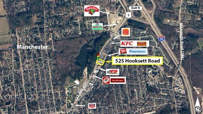
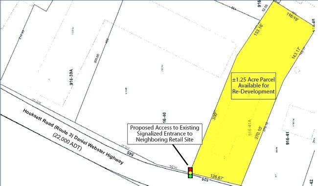
555 Hooksett Rd
MNCH-000916-000000-000039A
HILLSBOROUGH
Regionalshoppingcenterormallwithanchorstore
New Hampshire
B and X Area of moderate flood hazard, usually the area between the limits of the 100-year and 500-year floods.
39a
2024
1.59 AC
2024
Hillsborough
000700
Boston
50,771 SF
Manchester-Nashua, NH
NEARBY LISTINGS FOR SALE OR LEASE
-
-
-
-
-
-
-
No Photo
-
View all Manchester listings for sale on LoopNet.com
DEMOGRAPHICS near 555 Hooksett Rd
1 mile
3 mile
5 mile
2025 Total Population
10,887
91,298
137,086
2030 Population
10,972
91,753
138,293
Pop Growth 2025-2030
+ 0.78%
+ 0.50%
+ 0.88%
Average Age
42
40
40
2025 Total Households
4,507
38,865
56,549
HH Growth 2025-2030
+ 0.82%
+ 0.59%
+ 0.94%
Median Household Inc
$115,183
$81,568
$87,097
Avg Household Size
2.20
2.20
2.30
2025 Avg HH Vehicles
2.00
2.00
2.00
Median Home Value
$418,896
$377,093
$377,033
Median Year Built
1967
1962
1970
Nearby Places
Map Layers
Map Styles
 Street
 Aerial
Layers
 Traffic
 Biking
Places
Listings with unknown addresses are not visible on the map
- Restaurants
- Banks
- Shops
- Fitness
- Groceries
PUBLIC TRANSPORTATION
AIRPORT
Manchester Boston Regional
Drive
Walk
Distance
Manchester Boston Regional
20 min
10.3 mi
Freight Ports
Port of Boston
Drive
Walk
Distance
Port of Boston
85 min
58.2 mi
SALE & LEASE HISTORY
LISTING DATE
SALE/LEASE

Mar 13, 2017
For Sale
Nearby Properties
Address
Land Use
TOTAL SIZE
Lot Size
Zoning
Address
Land Use
TOTAL SIZE
Lot Size
Zoning
12.60 AC
PZ
Address
Land Use
TOTAL SIZE
Lot Size
Zoning
6,830 SF
17.24 AC
Address
Land Use
TOTAL SIZE
Lot Size
Zoning
256,041 SF
6.69 AC
Address
Land Use
TOTAL SIZE
Lot Size
Zoning
135,686 SF
30.23 AC
Address
Land Use
TOTAL SIZE
Lot Size
Zoning
36,070 SF
141.66 AC
MUD4
Address
Land Use
TOTAL SIZE
Lot Size
Zoning
250,905 SF
1.16 AC
Address
Land Use
TOTAL SIZE
Lot Size
Zoning
229,089 SF
3.58 AC
Address
Land Use
TOTAL SIZE
Lot Size
Zoning
135,879 SF
2.36 AC
Address
Land Use
TOTAL SIZE
Lot Size
Zoning
26,125 SF
150.66 AC
Address
Land Use
TOTAL SIZE
Lot Size
Zoning
143,630 SF
57.86 AC
Address
Land Use
TOTAL SIZE
Lot Size
Zoning
16,464 SF
15.19 AC
Address
Land Use
TOTAL SIZE
Lot Size
Zoning
398,130 SF
1.68 AC
Address
Land Use
TOTAL SIZE
Lot Size
Zoning
221,144 SF
3.77 AC
Address
Land Use
TOTAL SIZE
Lot Size
Zoning
237,634 SF
5.39 AC
Address
Land Use
TOTAL SIZE
Lot Size
Zoning
24,064 SF
19.44 AC
Address
Land Use
TOTAL SIZE
Lot Size
Zoning
16,000 SF
58.17 AC
Address
Land Use
TOTAL SIZE
Lot Size
Zoning
51.32 AC
MUD4
Address
Land Use
TOTAL SIZE
Lot Size
Zoning
211,525 SF
93.01 AC
Address
Land Use
TOTAL SIZE
Lot Size
Zoning
181,610 SF
0.58 AC
Address
Land Use
TOTAL SIZE
Lot Size
Zoning
165,000 SF
3.38 AC
Address
Land Use
TOTAL SIZE
Lot Size
Zoning
230,582 SF
0.31 AC
Address
Land Use
TOTAL SIZE
Lot Size
Zoning
154,363 SF
17.25 AC
MUD3
Address
Land Use
TOTAL SIZE
Lot Size
Zoning
148,880 SF
2.38 AC
Address
Land Use
TOTAL SIZE
Lot Size
Zoning
264,671 SF
4.04 AC
Address
Land Use
TOTAL SIZE
Lot Size
Zoning
42,795 SF
17.92 AC
Address
Land Use
TOTAL SIZE
Lot Size
Zoning
8,318 SF
8.71 AC
Address
Land Use
TOTAL SIZE
Lot Size
Zoning
38,506 SF
9.88 AC
Address
Land Use
TOTAL SIZE
Lot Size
Zoning
515,760 SF
0.04 AC
Address
Land Use
TOTAL SIZE
Lot Size
Zoning
130,851 SF
2.07 AC
Address
Land Use
TOTAL SIZE
Lot Size
Zoning
206,478 SF
3.91 AC
The World's #1 Commercial Real Estate Marketplace
Connect with us
© 2026 CoStar Group
The information above has been obtained from sources believed reliable. While we do not doubt its accuracy we have not verified it and make no guarantee, warranty or representation about it. It is your responsibility to independently confirm its accuracy and completeness. Any projections, opinions, assumptions, or estimates used are for example only and do not represent the current or future performance of the property. The value of this transaction to you depends on tax and other factors which should be evaluated by your tax, financial, and legal advisors. You and your advisors should conduct a careful, independent investigation of the property to determine to your satisfaction the suitability of the property for your needs.